Algeria
Wilaya de Skikda, Algeria — Towns & Travel Guide


A coastal province of north-eastern Algeria, where the port of Skikda gathers Mediterranean beaches, pine hills, and the ruins of Roman Rusicade.
About Wilaya de Skikda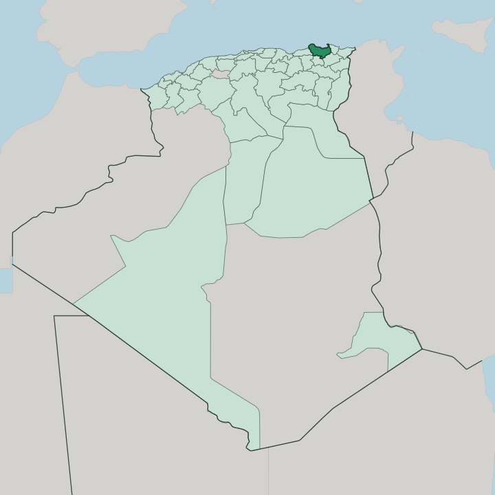


Towns & cities in Wilaya de Skikda
Pick a town or city — each links to where to stay.
Skikda itself is the natural base. The capital sits on the Gulf of Stora, its corniche and old Philippeville streets close to the ferries and the fishing quay at neighbouring Stora. West along the coast, Collo offers a quieter stay beneath its massif, with rocky coves reached by winding cliff roads.
Inland, El Harrouch anchors the Oued Saf-Saf valley among strawberry and citrus farms. Pick the coast for beaches; pick the valley for farm country.
About Wilaya de Skikda
Oil, gas, and strawberries.
What is Wilaya de Skikda known for?
The port of Skikda handles Algeria's third-largest commercial traffic after Algiers and Oran, and the refineries and liquefied-gas plants built along its shore in the 1970s made the province one of North Africa's petrochemical anchors. Its coast is the other face. Beaches run west from Stora's old fishing harbour toward the cliffs and coves of Collo, while inland the strawberry fields around the town supply markets across the country.
The Roman theatre of Rusicade still marks the hill above the modern streets.
Where is Wilaya de Skikda?
Wilaya de Skikda takes in the Mediterranean shore of north-eastern Algeria, east of the capital at Algiers. Its coastline runs about 130 km. That shore stretches from El Marsa in the east to the Oued Z'hour in the deep Collo country to the west, a run of headlands, sandy bays, and cliffed capes.
Small coastal plains break the hills only near the river mouths. Inland the province climbs quickly, and it shares borders with Annaba and Guelma to the east, with Constantine and Mila to the south, and with Jijel to the west. Mountains fill most of the interior.
The Collo massif rises in the west, its wooded ridges reaching well over a thousand metres and forming part of the coastal Tell Atlas that walls off the coast from the high plains around Constantine. Between the ranges the Oued Saf-Saf drains north through a fertile valley to the sea, reaching the coast beside Skikda itself on the Gulf of Stora. Terraced strawberry fields and citrus groves cover the lower Saf-Saf, the produce that has long made the district's name.
The port city stands at that valley's mouth. Rivers, ridges, and a single deep gulf set the shape of the province.
What is Wilaya de Skikda like?
Life in the province turns on the sea and the harvest. Arabic is the everyday language, with French still heard in the older streets and Berber in the mountain villages of the Collo massif. Skikda's centre keeps the grid the French laid out for Philippeville, its squares and arcaded avenues climbing back from the port, and above them the depleted stones of the Roman theatre of Rusicade still hold the hillside.
Fishing crews land their catch at Stora, and the grilled sardines and seafood of its quayside restaurants are a point of local pride. Café tables spill onto the corniche in the warm evenings, a habit inherited from the Mediterranean towns all along this coast. Away from the water the land is farm country.
The strawberry is the province's signature crop, celebrated each season with a festival at Skikda that draws growers from across the surrounding communes. Citrus, tobacco, and cork come off the same hills. The result is a culture split between two rhythms: the industrial port with its refineries and tankers, and the older world of fishing quays, terraced orchards, and Sunday markets.
Both belong to Skikda.
What is the history of Wilaya de Skikda?
The coast here is old. Phoenician and Carthaginian traders worked a post they called rškd on the cape, and under Rome it grew into Rusicade, the Mediterranean port of inland Cirta, holding the largest Roman theatre in Algeria, raised in Hadrian's day. The site then lay largely abandoned for centuries.
French forces founded a new town on the ruins in 1838 and named it Philippeville for King Louis-Philippe, laying out the grid that still climbs from the harbour. It took back the name Skikda at independence in 1962, and the modern province was carved from the Constantine department in 1974.
What is the climate of Wilaya de Skikda?
Skikda has a Mediterranean climate. Summers along the coast are hot and dry, tempered by sea breezes off the Gulf of Stora, while the rain arrives in the mild winters between autumn and early spring. The Collo massif catches the heaviest downpours, and its wooded slopes stay greener and cooler than the coast below through the dry months.
Snow is rare, and only the highest ridges see it. The Saf-Saf valley ripens its strawberries early on this warm, sheltered shore.
How do you get to Wilaya de Skikda?
Skikda has no airport of its own. Travellers fly into Mohamed Boudiaf International at Constantine, about 90 km to the south, or into Rabah Bitat at Annaba a similar distance east, then finish the trip by road over the Tell Atlas. The port city is also a rail terminus: the Algiers-Skikda line, one of the two trunk routes of the Algerian network, climbs inland up the Saf-Saf valley toward Constantine.
Its harbour stays a working commercial and petrochemical port, not a way most visitors arrive. Collo and the western beaches lie an hour west along the coast road.
Good for
Updated July 2026