Algeria
Wilaya de Médéa, Algeria — Towns & Travel Guide


Wilaya de Médéa is a highland province south of Algiers, where vineyard hills climb into the Titteri range of the Tell Atlas.
About Wilaya de Médéa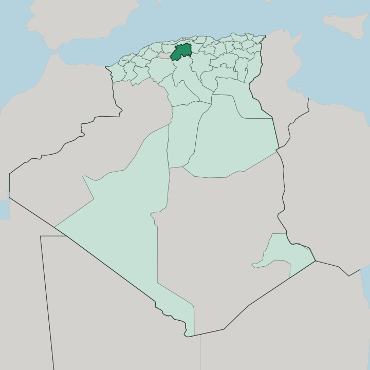


Towns & cities in Wilaya de Médéa
Pick a town or city — each links to where to stay.
Médéa holds the hotels. The capital keeps most of the province's beds, up on its plateau within reach of the vineyard slopes and the old Ottoman kasbah. Berrouaghia lies south along the RN1, a working road-and-rail town at the edge of the cereal plains, while Ksar El Boukhari guards the southern rim where the Titteri drops away toward the steppe.
Smaller places like Tablat and Beni Slimane run to guesthouses and little else. Base yourself in Médéa for the wine hills and the beylik town within a short drive.
About Wilaya de Médéa
Médéa is wine country.
What is Wilaya de Médéa known for?
The capital, also called Médéa, grew up as the seat of the Titteri beylik under the Ottomans, and its surrounding hills have carried vineyards and orchards for centuries. The province covers the Titteri itself, the mountainous core of the southern Tell Atlas, where cedar and Aleppo pine thin out southward into bare, semi-arid steppe. Grain, olives and those vineyards are still the country's living.
It sits above Algiers and the coast, trading the sea for altitude.
Where is Wilaya de Médéa?
Wilaya de Médéa fills a stretch of north-central Algeria, inland from the coast and directly south of Algiers. The land is mountainous. It sits on the Titteri, the block of the southern Tell Atlas that gives the old beylik its name, a country of forested ridges, high plateaux and deep wadis.
The capital stands roughly a kilometre up, on a plateau shadowed to the north-west by the wooded crest of Djebel Nador. To the north the ground falls sharply toward the Mitidja plain and the province of Blida; southward it climbs and then dries, the cedar and pine of the heights giving out to the semi-arid steppe that runs on toward the High Plateaus. Water divides here rather than gathers.
The heights around Médéa form a watershed: streams run north to the wadis Chiffa and Isser and the sea, while others feed south and west into the Chelif, the longest river in Algeria. Berrouaghia and Ksar El Boukhari mark the line where the wet northern hills give way to the cereal plains and the steppe beyond. Blida lies over the northern ridges, and the drier provinces of the interior wrap the province to the south and west.
It is a province of edges, hung between the green Tell and the dry country below it.
What is Wilaya de Médéa like?
Médéa is Arabic-speaking, like most of the Algerian Tell, and French still turns up in the market and the schoolroom. Its roots run deeper. The Titteri hills were Berber country before Arab tribes of the Banu Hilal settled the land after the eleventh century, and both strains sit in the place-names and the speech.
Three centuries as an Ottoman beylik left the strongest mark. The capital keeps an old walled kasbah and its mosques, the seat where the bey of the Titteri once ruled for the Dey of Algiers. Wine is the other inheritance.
The hills above the town have grown vines since long before the French turned them into export vineyards, and the grape still shapes the working year alongside the grain, the olives and the flocks. Life here is agrarian and unshowy. Village honey, home-baked bread and hillside orchards carry more of the character than any monument does.
Weekly markets in Berrouaghia and Ksar El Boukhari still gather the produce of the plains, and copper, leatherwork and other handicrafts trade alongside the fruit and the flour. It is a quiet, inland Algeria, more field and vine than boulevard.
What is the history of Wilaya de Médéa?
Médéa began as a Roman way-station, Media, 'halfway', on the road between the coast and the interior. The name stuck. A town grew on the plateau in the tenth century.
Its great age came under the Ottomans: from the sixteenth century Médéa was capital of the Beylik of Titteri, and a bey governed the province there for the Dey of Algiers until 1830. After the Treaty of Tafna in 1837 it briefly served Abdelkader's state, then fell to France and stood as an army garrison town until Algerian independence in 1962.
What is the climate of Wilaya de Médéa?
Médéa owes its climate to its elevation on the Titteri plateau. Up on its plateau Médéa is cooler and wetter than the coast below, with a Mediterranean mountain climate: mild, green springs, hot dry summers, and cold winters that dust the Titteri ridges and Djebel Nador with snow. Rain falls mostly between autumn and spring.
The pattern shifts as the land drops southward, the wet Tell gives way to the semi-arid steppe, where the air turns hotter and drier toward the interior. It is a province of two climates, split by the mountains.
How do you get to Wilaya de Médéa?
There is no airport here. Most travellers fly into Algiers, then drive south on the RN1, the trunk road that climbs out of the Mitidja and over the Tell Atlas to the plateau, roughly a two-hour run by car or intercity bus. The road keeps going.
South of Médéa it threads Berrouaghia and Ksar El Boukhari on its long haul toward the Sahara. Shared taxis and buses link the daïra towns, but a car earns its keep in the hills.
Good for
Updated July 2026