Estonia
Saaremaa, Estonia — Towns & Travel Guide


Saaremaa is Estonia's largest island, a low limestone land of windmills, juniper heath and the spa town of Kuressaare.
About Saaremaa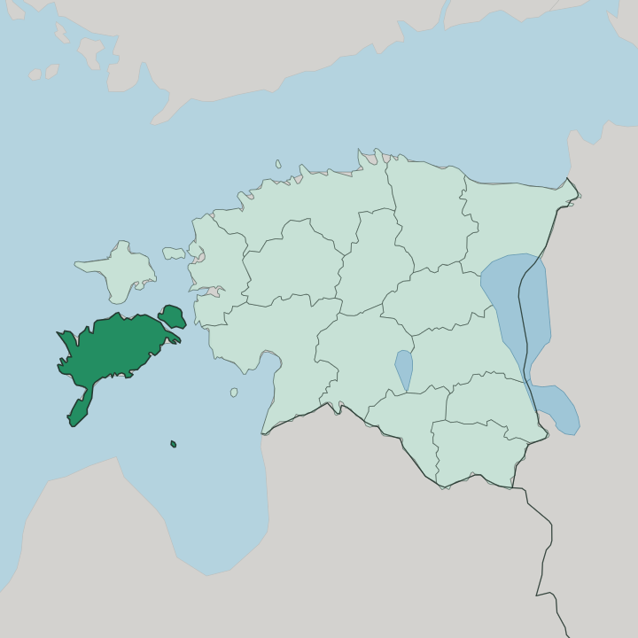
Towns & cities in Saaremaa
Pick a town or city — each links to where to stay.
Kuressaare holds almost every bed on the island. It is the obvious base. Its spa hotels sit within a short walk of the castle bastions and the harbour, and the town works as a hub for day trips out to the capes and craters.
Beyond it, beds thin out fast. The Sõrve peninsula strings a few guesthouses down its long spit toward the lighthouse, Muhu offers converted farmsteads near the ferry landing, and the Kaali and Angla countryside keeps small rural stays close to the crater and the mills. Choose Kuressaare for comfort and everything within reach; choose the rural coast for the quiet, distance-lit island instead.
About Saaremaa
Saaremaa is the biggest island in Estonia.
What is Saaremaa known for?
Windmills stand for it. The Angla ridge keeps five old wooden mills in a row, and their sails have become the island's unofficial emblem alongside the round bastions of Kuressaare Castle. Then there is the sky itself: the Kaali crater field, punched into the bedrock by a meteorite that fell here in the Bronze Age, holds a water-filled bowl 110 metres across.
Juniper scrub, dolomite cliffs and a slow, self-contained island culture do the rest.
Where is Saaremaa?
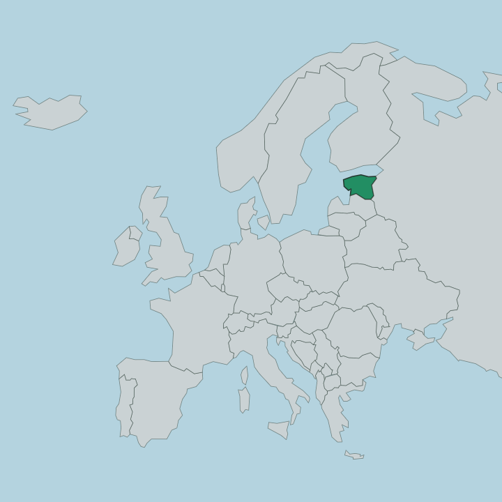
Saaremaa is the largest and westernmost of the Estonian islands, set in the Baltic Sea off the country's western shoulder. It anchors the West Estonian archipelago. Hiiumaa lies to the north across a narrow strait, the open Baltic opens to the west, and the Gulf of Riga curls in below the island's southern coast toward Latvia.
The land itself is flat and low. Limestone and dolomite lie just under the thin soil, and in places the sea has stripped it bare into pale cliffs. The best of them is Panga, a wall of bedrock more than twenty metres high running along the northern coast.
Reaching Saaremaa means island-hopping. You cross first to Muhu, the smaller island where the mainland ferry lands, then drive the Väinatamm causeway that carries the road over the shallow strait onto Saaremaa proper. The coastline is ragged with bays and capes.
The Sõrve peninsula reaches farthest, a long southern spit pointing down into the Gulf of Riga toward the Latvian shore, tipped by a lighthouse. Juniper heath, reed shore and grazed coastal meadow cover much of the ground between the villages. Kuressaare, the only town, sits on that southern coast facing the gulf.
It is the westernmost town in Estonia. Everywhere here the sea is close, and the whole island reads as a raised shelf of old seabed barely lifted above the Baltic.
What is Saaremaa like?
Islanders here keep a language of their own. The Saaremaa dialect still colours everyday Estonian across the villages, softened and turned by centuries of living apart from the mainland. That apartness runs through the whole culture.
Old wooden windmills, thatched barns and dry-stone field walls speak of a farming and fishing life that changed slowly, and the five preserved mills on the Angla ridge stand as the plainest emblem of it. A home-brewed village beer called koduõlu is still made here by old recipe. Kuressaare gives the island its one urban face.
Its pastel wooden houses ring a market square and the great moated castle, and a spa tradition begun in the nineteenth century still draws people to the town to take the curative mud and the sea air. Faith and stone sit close together too. Squat medieval churches at Kaarma, Valjala and Karja carry carved doorways and old wall paintings, built when the island was ruled from a bishop's seat.
The result is a culture that feels older and slower than the Estonian mainland. Craft, church, mill and malt hold it together. Saaremaa wears its distance as identity.
What is the history of Saaremaa?
The crusaders came in 1227. That year the Livonian Brothers of the Sword conquered Saaremaa, ending the resistance of its seafaring islanders and founding the Bishopric of Ösel-Wiek, whose bishops raised the great stone castle at Kuressaare that still stands. Rule then passed from hand to hand for centuries: Danish, then Swedish after the Treaty of Brömsebro, then Russian after the Treaty of Nystad in 1721 folded the island into the Governorate of Livonia.
Kuressaare grew into a genteel spa resort under that long imperial peace. Estonian independence in the twentieth century, broken by Soviet occupation and won back in 1991, finally left the island governing itself.
What is the climate of Saaremaa?
The Baltic rules the weather here. Ringed by sea on every side, Saaremaa runs milder and later than mainland Estonia, its winters eased and its summers held back by the slow-warming water of the Gulf of Riga. Frosts arrive gently and spring comes late.
Summer is the season the island keeps for itself, when the juniper heaths dry out, the coastal meadows flower and the long light draws walkers and birdwatchers to the capes. Autumn storms roll in off the open Baltic to close it. Sea mist is common on the low shore.
How do you get to Saaremaa?
Most people arrive by ferry. The crossing runs from Virtsu on the mainland to Kuivastu on Muhu, a shallow half-hour hop across the strait, and from there the Väinatamm causeway carries the road on across the water to Saaremaa itself. Book the boat ahead in summer.
A small airport just outside Kuressaare takes short flights from Tallinn for those who would rather fly the island in half an hour than drive and sail it. Buses from Tallinn roll straight onto the ferry deck and off again, the crossing folded into one through ticket, and set down at last in Kuressaare.
Good for
Updated July 2026