Ethiopia
Tigray Region, Ethiopia — Towns & Travel Guide


Tigray is Ethiopia's northernmost region, an ancient highland of rock-hewn churches, Aksumite obelisks, and the deep Tekezé gorge.
About Tigray Region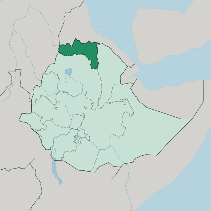
Towns & cities in Tigray Region
Pick a town or city — each links to where to stay.
Mekelle is the natural first base. The regional capital sits high on the northern plateau, and its airport and bus stands are where most trips into Tigray begin. Sleep in Gheralta, northwest of Wukro, when the rock-hewn churches are the reason you came.
Axum suits travellers drawn to the Aksumite stelae and the ruined royal town, its obelisk fields, and its Queen of Sheba legends. Shire Inda Selassie is a transit stop. Choose Mekelle to arrive; choose Gheralta or Axum for the churches and the antiquities.
About Tigray Region
Tigray is Aksum country.
What is Tigray Region known for?
The ruined capital of the Kingdom of Aksum stands here, its towering carved stelae marking the graves of kings who once ran the Red Sea trade. The region is equally famous for its rock-hewn churches, more than a hundred of them cut into the sandstone cliffs of Gheralta and the surrounding highlands. Adwa, west of Mekelle, gave its name to the 1896 battle where an Ethiopian army turned back an invading Italian force.
Tigrinya is the language of daily life, written in the same Geʽez script the Aksumites used.
Where is Tigray Region?
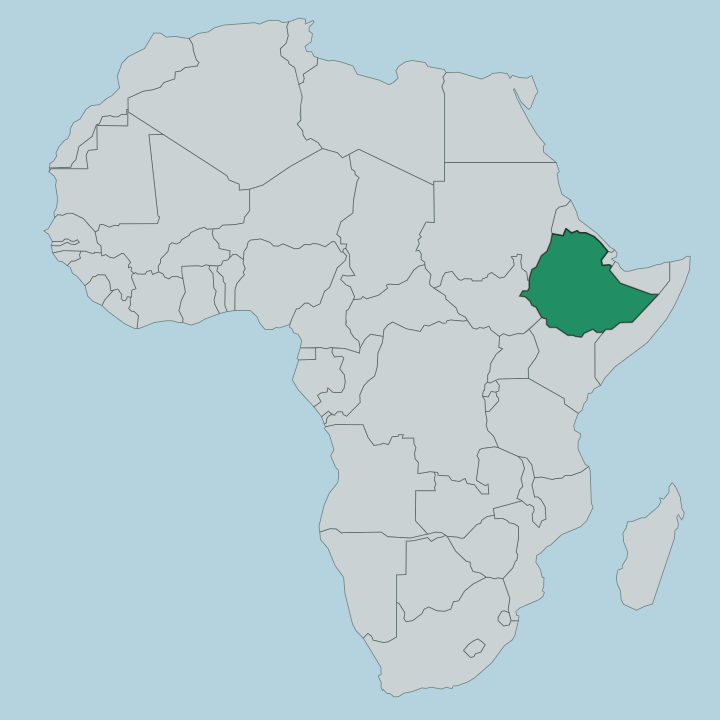
Tigray fills the far north of Ethiopia, a block of highland pressed against the country's outer edges. Eritrea lies across the northern border, and the Mareb and Tekezé rivers have long marked that line. To the west the land runs toward Sudan; to the south it meets the Amhara Region; to the southeast it drops away into the Afar Region. Most of Tigray sits on the northern Ethiopian Plateau, a rugged tableland of ridges and flat-topped hills carved by seasonal rivers.
The plateau is deeply cut. The Tekezé has gouged a gorge that falls thousands of feet below the surrounding uplands, draining the region's water west and north toward the Nile. Along the eastern and western margins the highland breaks in escarpments.
On one side they plunge toward the Sudanese plains, and on the other toward the searing Afar lowlands. That eastern drop leads down into the Danakil Depression, one of the lowest and hottest places on Earth, sunk well below sea level in the rift beyond Tigray's edge. Mekelle, the capital, stands on the plateau in the region's east, more than two kilometres up.
Aksum and Adwa lie to the northwest, on gentler highland ground near the base of the Adwa mountains. Elevation shapes everything here. The high, cool plateau holds the towns and the churches, while the hot lowland trenches wall the region off along its rim.
What is Tigray Region like?
Faith and rock define daily life in Tigray. The people are Tigrayans, and their language is Tigrinya, a Semitic tongue descended from the Geʽez of the Aksumites and still written in the same ancient script. Most are Ethiopian Orthodox Tewahedo Christians, and the region's churches are not merely places of worship but feats of engineering hewn straight into cliff and stone.
Some sit atop sheer sandstone pinnacles in Gheralta, reached only by climbing the bare rock with hands and bare feet. Priests keep them still. Painted saints look down from ceilings darkened by centuries of candle smoke, and the great religious festivals fill the church compounds with white-robed worshippers and the low drum of the liturgy.
Coffee is a ritual rather than a drink, roasted, brewed, and poured in slow rounds that can fill an afternoon. Injera, the sour flatbread shared across Ethiopia, comes to the table with fiery stews. Tigray also carries a long memory of resistance, from the Aksumite kings to the victory at Adwa that kept Ethiopia independent when the rest of the continent fell to European empires.
That history is worn with pride. It runs through the songs, the church walls, and the way people speak of their own past.
What is the history of Tigray Region?
The roots here run deep. Long before Aksum, a society the inscriptions call Dʿmt centred on Yeha, whose tall stone temple still stands in the Tigrayan hills. From the first century the Kingdom of Aksum rose in its place, minting its own coins and reaching across the Red Sea to trade with Arabia, Rome, and India.
Around the fourth century King Ezana made Aksum Christian. The Geʽez script and church tradition born then still shape the region, and in 1896 an Ethiopian army defeated an invading Italian force at Adwa, a victory that rang far beyond Tigray.
What is the climate of Tigray Region?
Altitude tames the heat here. Mekelle and the highland towns sit high enough on the plateau for a cool, semi-arid climate, with warm days and chilly nights rather than the fierce heat of the lowlands below. The year splits into a dry stretch and a summer rainy season, when storms sweep the highlands and briefly fill the Tekezé and its tributaries.
Rain is never guaranteed, and drought has scarred the region's past. Drop off the escarpment toward the Danakil, though, and the cool gives way fast to some of the hottest air on the planet.
How do you get to Tigray Region?
Most travellers reach Tigray by air. Mekelle, the regional capital, has the main airport, a little under 780 kilometres north of Addis Ababa and a long haul over the highlands by road. Overland, the route climbs up from Gondar and Debark to the west, changing vehicles at Shire Inda Selassie for Axum.
Within the region, roads thread between the plateau towns and the rock-hewn churches, though the steepest of the churches are reached only on foot from the road. The Eritrean border lies just to the north.
Updated July 2026