Kenya
Makueni, Kenya — Towns & Travel Guide


Makueni is a semi-arid county in southeastern Kenya, running from the Mbooni Hills down to the Chyulu Hills and the plains toward Tsavo.
About Makueni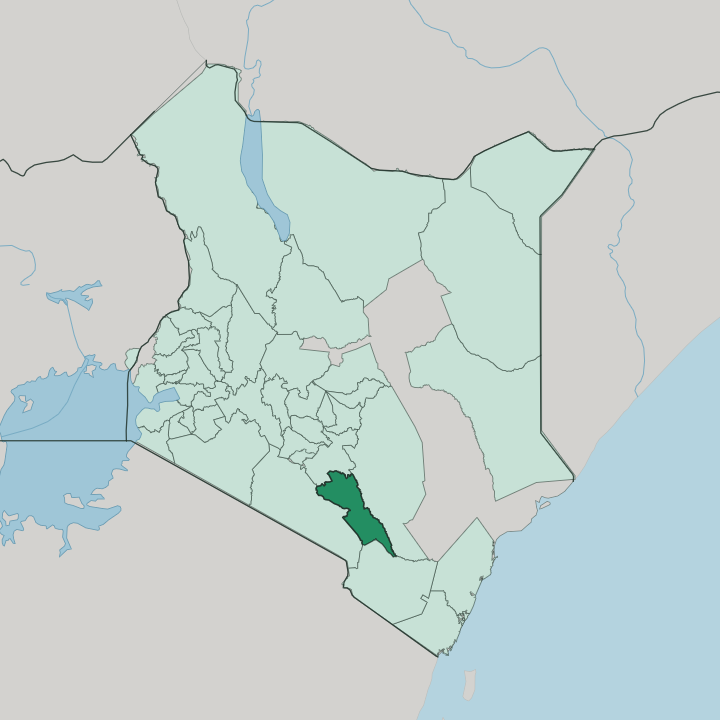


Towns & cities in Makueni
Pick a town or city — each links to where to stay.
Most beds sit along the Nairobi-Mombasa road, not in Wote. Makindu is the classic stop, where the roadside Sikh temple has fed and lodged travellers for free since the Uganda Railway crews first camped there. Mtito Andei is the halfway stop.
Its gate opens into Tsavo West National Park. Kibwezi sits beside Kibwezi Forest and the Umani Springs, in the shadow of the Chyulu Hills. Pick the highway towns for a bed; pick the forest edge for elephants.
About Makueni
What is Makueni known for?
Makueni is Kenya's mango country. Orchards spread across the lowlands, and a county fruit-processing plant at Kalamba turns the harvest into puree and juice rather than letting it rot in the sun. The land itself is the other headline, tilting from the cool Mbooni Hills in the northwest down through open plains to the volcanic Chyulu Hills.
Wote is the county town. The Nairobi-Mombasa highway and the Standard Gauge Railway both cut across the county, with Emali and Makindu strung along that corridor as market and railway stops.
Where is Makueni?
Makueni fills a wedge of southeastern Kenya, in the former Eastern Province. It belongs to Ukambani, the Kamba homeland it shares with Machakos and Kitui counties. Machakos County lies along the northern border, Kitui County to the east, Taita-Taveta County to the south, and Kajiado County to the west. The ground drops from north to south.
Cool highland country in the northwest, the Mbooni Hills and the Kilungu ridges, gives way to hot open plains that slope toward the Kibwezi lowlands and the volcanic Chyulu Hills along the southwestern rim. Water is the county's defining scarcity. Three permanent rivers cross it, the Athi, the Kambu and the Kiboko, and every one of them drains southeast toward the Athi-Galana-Sabaki system and the Indian Ocean.
Between those channels the country runs dry. Seasonal streams hold water only after the rains, which is why sand dams and earth pans dot the plains wherever farmers can trap a little runoff. Nzaui hill breaks the horizon near the centre, and the Chyulu range walls off the southwest, its young lava too porous to keep surface water yet feeding the clear springs inside Kibwezi Forest.
What is Makueni like?
This is Kamba country through and through. Most people here speak Kikamba first, farm smallholdings of maize, pigeon peas and mangoes, and trace their families to the wider Ukambani region. The Kamba built a name in the nineteenth century as long-distance traders, carrying ivory, honey and beeswax between the interior and the Swahili coast at Mombasa.
That trading reach left its mark. Kamba woodcarvers still supply much of the sculpture sold in Kenya's craft markets, and the county's basketry and pottery carry the same handwork. Music and dance run loud here.
The Kamba are known across Kenya for acrobatic dancers who somersault to fast drumming, a tradition kept alive at community gatherings and at the Makueni cultural events in Wote. Self-help is the other thread. Neighbours pool labour in mwethya groups to build the sand dams and terraces that keep the dry land farmable.
Faith matters too, with churches anchoring most towns. It is a rural county, and the rhythm of planting and harvest still sets the pace of the year.
What is the history of Makueni?
The county's oldest colonial mark sits at Kibwezi, where an East African Scottish Mission opened in 1891, one of the first inland stations in British East Africa before malaria drove it north to Kikuyu. The Uganda Railway came next, and towns like Makindu and Mtito Andei grew from its trackside stations. Makueni itself began as a settlement scheme, colonial officers clearing bush to move Kamba families off the crowded hills of western Machakos.
The line drew people south. It stayed part of Machakos until 1992, became a district, then a full county in 2013.
What is the climate of Makueni?
Makueni runs hot and dry for most of the year. Rain comes in two seasons, the long rains around March to May and the short rains toward the end of the year, but both are unreliable and drought is a recurring worry. Altitude splits the county in two.
The Mbooni Hills and the Chyulu Hills in the west catch more cloud and stay green and cool, while the Kibwezi lowlands bake. Failed rains here mean failed harvests.
How do you get to Makueni?
Most travellers reach Makueni by the Nairobi-Mombasa highway, the A109, which runs the length of the county on its way to the coast. The Standard Gauge Railway shadows the same route, and the Madaraka Express stops at Emali, Kibwezi and Mtito Andei. From Emali a branch road climbs west to Wote, the county town.
There is no commercial airport. The nearest big airfields are in Nairobi, a couple of hours up the highway, with only small airstrips scattered nearer the parks.
Updated July 2026