Kenya
Taita Taveta, Kenya — Towns & Travel Guide


Taita Taveta is a county in south-eastern Kenya where the green Taita Hills rise above the dry Tsavo plains, between Mombasa and Mount Kilimanjaro.
About Taita Taveta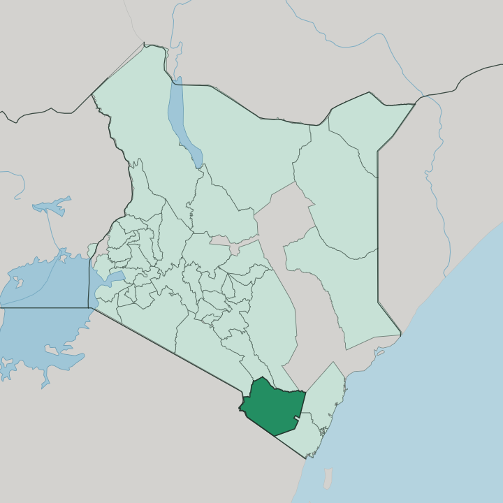


Towns & cities in Taita Taveta
Pick a town or city — each links to where to stay.
Voi is the practical base, the largest town and the road-and-rail junction that most Tsavo East trips pass through. For the parks themselves, safari lodges cluster in the Taita Hills Wildlife Sanctuary between Tsavo East and Tsavo West, some raised on stilts above their own floodlit waterholes. Wundanyi is different.
It suits walkers, a cool town high in the Taita Hills. Taveta lies far west, near Lake Chala and Lake Jipe on the Tanzania border.
About Taita Taveta
Two things define the county: elephants and hills.
What is Taita Taveta known for?
Most of Taita Taveta lies inside Tsavo East National Park and Tsavo West National Park, whose red-dust plains hold some of the largest elephant herds in Kenya and the freshwater pools of Mzima Springs. Above them stand the Taita Hills, cool forested islands of rock that shelter plants and birds found nowhere else on Earth. The ground itself is a draw.
Miners here dig tsavorite, the green garnet named for Tsavo, alongside ruby and tourmaline.
Where is Taita Taveta?
Taita Taveta lies inland in south-eastern Kenya, part of the coastal region, on the long road between Mombasa and the Tanzania border. The land splits cleanly in two. Across most of it spread the flat, dry plains of Tsavo, where Tsavo East National Park and Tsavo West National Park together fill close to two-thirds of the county.
Out of those plains rise the Taita Hills, a green massif of forested peaks that climbs to Vuria, the highest ground in the county. These hills belong to the Eastern Arc Mountains, an ancient chain running down through Tanzania, and their cloud forests hold species carried on that geological thread. Water gathers at the western edge.
There, near the town of Taveta, the crater lake of Lake Chala and the reedy shallows of Lake Jipe sit astride the frontier with Tanzania, under the snows of Mount Kilimanjaro. The Tsavo River cuts west to east through the parks, and the Lumi River runs down off Kilimanjaro to feed Lake Jipe. In Tsavo West, the clear pools of Mzima Springs well up from porous volcanic rock.
Voi anchors the eastern lowlands. Mombasa and the Indian Ocean lie beyond, to the south-east.
What is Taita Taveta like?
Two peoples give the county its name. The Taita live in and around the hills, historically split into three groups by the massif they farmed: the Wadawida of the Dawida hills, the Wasagalla of Sagalla, and the Wakasigau of Kasigau. Their language is Kidawida, one of the Bantu tongues, though Swahili and English carry daily business.
West by the lakes are the Taveta, a separate people with their own speech and their own history along the Tanzania border. Life in the hills is worked by hand. Steep slopes are cut into terraces of maize, beans, and vegetables, and dairy cattle graze the higher ground.
Older belief still marks the landscape. Caves in the hills, called Mbanga, once held the skulls of revered elders, and certain rocks were kept as shrines where rain and blessing were sought. Music runs through it too.
The Taita composer Fadhili William wrote Malaika, among the best-known Swahili songs ever recorded, its melody sung far beyond Kenya. Down on the plains, the culture turns outward to wildlife and the safari trade that Tsavo built. Sisal estates stripe the lowlands near Voi.
Hill and plain keep different rhythms.
What is the history of Taita Taveta?
Bantu-speaking Taita settled the hills long before Europeans came, farming in scattered clans rather than one kingdom. Resistance leaders like Mwangeka wa Malowa fought the British advance in the late nineteenth century. Voi grew as a depot on the Uganda Railway, and in the First World War the British threw a military line from Voi to Taveta to strike at German East Africa, fighting a hard action at Salaita Hill in 1916.
The modern county was drawn up in 2013.
What is the climate of Taita Taveta?
In Taita-Taveta, height above sea level sets the climate. The Tsavo lowlands around Voi run hot and dry for most of the year, semi-arid country where rain is thin and the heat builds through the afternoon. The Taita Hills are another world.
South-easterly winds pushing up the slopes wring out relief rain, so Wundanyi and the higher ground stay cool, green, and far wetter than the plains below. Two rainy seasons break the dryness. The long rains fall from March to May, the shorter rains from October to December.
How do you get to Taita Taveta?
Voi is the way in. The main highway and railway between Nairobi and Mombasa both run through the town, so most visitors reach the county by road or train from either city. Light aircraft are the other option, dropping onto airstrips inside Tsavo for travellers flying in from Nairobi.
West of the parks, Taveta guards a busy border crossing into Tanzania, the road running on toward Moshi and Arusha beneath Kilimanjaro. From there the mountain is close.
Good for
Updated July 2026