North Korea
Nampo, North Korea — Towns & Travel Guide


Nampo is North Korea's main west-coast port, sitting where the Taedong River widens into Korea Bay, southwest of Pyongyang.
Find your area →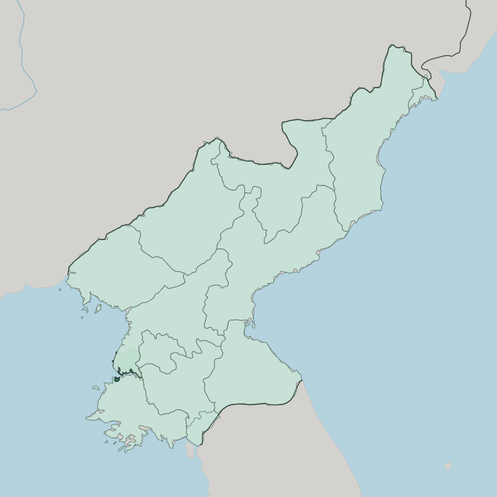
Towns & cities in Nampo
Pick a town or city — each links to where to stay.
Beds inside Nampo are thin. Most tours run the city as a day trip out of Pyongyang instead. Waudo, on the Taedong River, is the one district with anything resort-like: an enclosed bathing park under pine-topped hills.
Kangso to the north trades on its mineral springs. For an actual hotel you look up the Youth Hero Motorway to Pyongyang, an hour away, where the beds and the tour arrangements are. Base yourself in the capital and reach the barrage and the port by road.
About Nampo
Nampo is the harbour that serves Pyongyang.
What is Nampo known for?
It handles much of the traffic that cannot reach the capital directly, sitting at the seaward end of the Taedong River. The West Sea Barrage is the landmark here, an 8-km sea wall thrown across the river mouth in 1986, carrying a road and holding back Korea Bay behind three shipping locks and 36 sluices. Shipyards, a smelting complex, and glassworks line the waterfront, and the orchards of Ryonggang county behind the city are known across the country for their apples.
Where is Nampo?
Nampo stands on the west coast of North Korea, on the northern shore of the Taedong River where it opens into Korea Bay. The city sits roughly 50 km southwest of Pyongyang, downriver from the capital. It is a low place.
More than four-fifths of its land lies below 50 metres, a wide, gently rolling plain that runs out toward the water. The hills that do rise are pushed into the south and east, where the Osok range tops out at Osok-san, the highest point around the city. Korea Bay, which Koreans call the West Sea, is a northern arm of the Yellow Sea, and the Taedong is one of several rivers that empty into it.
Across the river mouth runs the West Sea Barrage, an 8-km wall of dam and locks that turned the tidal estuary into a controlled pool. The barrage reclaimed farmland from the bay and steadied the river's floods. South Pyongan Province wraps around the city inland, and Pyongyang lies upstream to the northeast. The sea to the west freezes at the edges through the coldest weeks, and shipping slows with it.
Everything about the setting is tied to that one river running down to the bay.
What is Nampo like?
Nampo is a working port before it is anything else, and the industry sets the tone. Cranes, the smelter, the glassworks and the shipyards define the waterfront, and the districts around them are laid out for labour rather than leisure. Yet the city is not only its docks.
The Taedong River bank at Waudo carries an enclosed bathing park where families come out from the city on hot days, with pavilions set on the pine-topped hills above the water. Kangso, north of the centre, has drawn people to its mineral springs far longer than the port has existed. The deeper past sits just inland.
In Ryonggang county the earth holds Goguryeo tombs from the fifth century, their painted chambers old enough to be listed by UNESCO, a reminder that this coast was settled long before the barrage or the smelter. Korean is the language spoken throughout, as it is across North Korea. Apples come down from the Ryonggang orchards each autumn, one of the few Nampo names known nationwide.
The city wears its two faces at once: heavy industry along the river, and older, quieter ground behind it.
What is the history of Nampo?
It began as a fishing village. Nampo opened to foreign trade in 1897, a small settlement pressed into service as a treaty port at the mouth of the Taedong River. After 1945 it grew fast into North Korea's principal western harbour.
Heavy industry followed the docks: a smelting complex, glassworks, and one of the country's main shipbuilding yards. Later the city was pulled out of South Pyongan Province and raised to special-city rank, absorbing the surrounding districts and counties as it grew.
What is the climate of Nampo?
The seasons here pull hard apart. Nampo runs on a monsoon climate: summers hot and wet, with the heaviest rain arriving from July into September as the monsoon pushes in off Korea Bay. Winters swing cold and dry.
They turn cold enough that the edges of the bay and the port ice over through the hardest weeks of the year. Spring and autumn are the short, clear breaks between. Most of the year's rain falls in that summer burst rather than spreading evenly, so the Taedong runs high through the wet months and the barrage earns its keep against the floods.
How do you get to Nampo?
Foreign visitors reach Nampo through Pyongyang. The capital lies about 50 km northeast, and the fast road between them is the Youth Hero Motorway, opened in 2000, which runs down the Taedong valley to the coast in roughly an hour. Independent travel is not allowed in North Korea.
So the trip is made on a guided tour, usually a day run out from Pyongyang to see the West Sea Barrage and the working port before returning up the motorway that evening. Rail lines serve the city too, but the road from the capital is how most people arrive.
Common questions
What is the best area to stay in Nampo?
Pyongyang: a proper hotel base.
Updated July 2026