North Korea
South Pyongan, North Korea — Towns & Travel Guide


South Pyongan is North Korea's western heartland province, where the Taedong River threads past Pyongsong toward Korea Bay.
Find your area →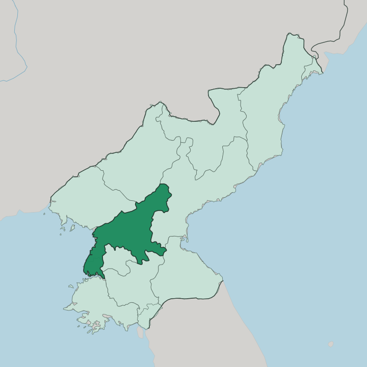
Towns & cities in South Pyongan
Pick a town or city — each links to where to stay.
Beds in South Pyongan are tied to organised group travel, and the province is usually seen on a day trip out from Pyongyang rather than as an overnight base. Pyongsong, half an hour up the road from the capital, is the one provincial city visitors are regularly shown. Nampo, at the mouth of the Taedong River, is the other stop, built around its harbour and the West Sea Barrage.
You come here on a fixed itinerary. Choose Pyongsong if the Academy of Sciences town and its market draw you; choose Nampo for the estuary, the sea barrage and the port.
About South Pyongan
What is South Pyongan known for?
South Pyongan wraps around Pyongyang on three sides in western North Korea. Its capital is Pyongsong, a planned city raised in 1969 to hold institutes moved out from the crowded national capital, and it is spoken of as the country's science town. Coal defines the north-western corner: Anju sits on one of the largest anthracite fields in the country, while Sunchon runs chemical, cement and pharmaceutical plants on the Taedong River.
The port of Nampo closes the province off to the west, where the West Sea Barrage dams the river's wide estuary. Grain grows on the plains between.
Where is South Pyongan?
South Pyongan fills the western middle of North Korea, curling around Pyongyang so that the national capital sits like an island inside the province. The Yellow Sea and its northern arm, Korea Bay, wash the western edge. Inland the land climbs east and north-east toward the mountains that separate the province from South Hamgyong.
North Pyongan and Chagang lie to the north; North Hwanghae closes it off to the south. Water is the organising fact of the province. The Taedong River, second-longest in the country, comes down out of the Rangrim Mountains and crosses South Pyongan on its way to the sea, passing Sunchon and the capital before reaching its mouth at Nampo.
The Ch'ongch'on River drains the north-western corner and runs past Anju to reach Korea Bay near Sinanju. Between the two rivers lie the low, fertile plains that make this one of the country's grain baskets. Coal seams run beneath the same ground, thickest around Anju in the north-west.
The province is compact. Nowhere in it is truly far from either a river or the capital next door.
What is South Pyongan like?
Two faces sit side by side in South Pyongan. One is scientific and industrial. Pyongsong was purpose-built to house institutes of the State Academy of Sciences, shifted out of Pyongyang from the 1970s, and the town grew up around laboratories rather than temples or old walls.
That gives the provincial capital an unusually planned, technical character for a Korean city, and locals half-jokingly call it the country's answer to a research valley. The other face is agricultural and old. Beyond the coal towns and chemical works, most of the province is farmland worked by cooperative farms on the Taedong and Ch'ongch'on plains.
This ground was Goguryeo country long ago. The kingdom that ruled northern Korea for seven centuries moved its capital to Pyongyang next door, and its tomb mounds and relics turn up across the river basin. Korean is the language, as everywhere in North Korea.
What visitors are shown here tends to be the model version of both faces. A tidy science city on one day, a cooperative farm or the sea barrage on the next.
What is the history of South Pyongan?
The province took its present shape in 1896, when the old Pyongan Province was split into northern and southern halves. Its ground is far older than that line. The Taedong basin was a core of Goguryeo, the kingdom that governed northern Korea until 668 and kept its capital at Pyongyang from the fifth century onward.
Pyongsong itself is new. The provincial capital was raised only in 1969, a deliberate overspill town for institutes and people crowding out of Pyongyang next door.
What is the climate of South Pyongan?
South Pyongan has a monsoon-influenced continental climate, and the year splits hard into two. Summers on the Taedong plain are hot and wet, with most of the rain arriving on the East Asian monsoon between June and September. Winters are the opposite.
Dry, cold winds push down from Siberia, and daytime temperatures on the coast near Nampo sit below freezing through much of the season. The turn between the two comes fast, over a few weeks each spring and autumn rather than by slow degrees.
How do you get to South Pyongan?
You come in through Pyongyang. The capital's airport and its rail links are the way into the country, and the province begins just beyond the city limits, so reaching South Pyongan means little more than driving out past the edge of town. Pyongsong sits half an hour up the road to the north-east.
Nampo lies south-west down the Taedong River toward the coast, tied to the capital by road and by the river itself. All of it is seen on an arranged group tour with a fixed route.
Common questions
What is the best area to stay in South Pyongan?
Nampo: the Taedong estuary, the West Sea Barrage and the harbour.
Good for
Updated July 2026