Kazakhstan
North Kazakhstan, Kazakhstan — Towns & Travel Guide


North Kazakhstan is a grain-belt region on the Ishim River, its steppe reaching north to the Russian border at Petropavl.
About North Kazakhstan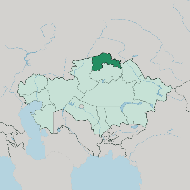
Towns & cities in North Kazakhstan
Pick a town or city — each links to where to stay.
Petropavl is where almost everyone stays. The regional capital sits on the right bank of the Ishim, and its station is the point every rail traveller passes through, so most beds cluster there within reach of the river and the line. For the lakes you go south into the Kokshetau Hills, where recreation centres ring Imantau rather than any single town.
Choose Petropavl for the river city and its trains; head to the Imantau lakes when you want pine forest and fishing water instead of the open plain.
About North Kazakhstan
Wheat, above all.
What is North Kazakhstan known for?
This is the northernmost region of Kazakhstan, a flat expanse of black-earth steppe that turns to grain fields every summer and feeds the country's export harvest. Petropavl anchors it, a river city on the Ishim close enough to Russia that trains from Moscow have long rolled through. The border is that near.
To the south the land lifts into the Kokshetau Hills, where lakes like Imantau draw people out of the plain for fishing and forest air.
Where is North Kazakhstan?
North Kazakhstan is the country's northernmost region, pressed against Russia along its whole upper edge. It is the smallest of Kazakhstan's regions by area, one of only a handful, and it faces three Russian oblasts across that northern border: Omsk, Kurgan, and Tyumen. Inside Kazakhstan it meets Akmola Region to the south, Pavlodar Region to the east, and Kostanay Region to the west.
Most of it is flat. The land belongs to the southwestern corner of the West Siberian Plain, a great low tableland that runs on for hundreds of kilometres into Russia, and here it carries a treeless grain steppe broken by shallow lakes and reed marshes. The Ishim River is the region's defining thread.
Also called the Esil, it is the longest tributary of the Irtysh, and it comes up out of the Kazakh Uplands, passes through Astana far to the south, then bends north through Petropavl and across the Ishim Steppe before crossing into Russia to meet the Irtysh. Only in the south does the ground rise. There the Kokshetau Hills lift out of the plain in granite outcrops and pine woods, cradling the lakes that make that corner the region's one piece of relief in an otherwise level land.
What is North Kazakhstan like?
This is the one corner of Kazakhstan where Kazakhs are not the majority. Russians outnumber them across the region, a legacy of the fortress line and the farming settlers who came with the railway, and the two communities have shaped its life together for well over a century. You hear as much Russian as Kazakh on the streets of Petropavl.
That mix runs deep. Orthodox churches and mosques stand within the same city grid, the older wooden merchant houses along the Ishim recall the Tsarist trade in hides and grain, and the food carries both traditions, from besbarmak to Siberian dumplings. Petropavl carries most of the region's cultural weight.
Its regional museum and the old drama theatre sit among the streets of that nineteenth-century core, and the city keeps the memory of Abai and of the wider Kazakh steppe alongside its Russian inheritance. Beyond the capital the character turns rural fast. The grain villages spread thin across the plain, tied to the harvest calendar and the long haul to the elevator, while in the south the Kokshetau lakes draw people to the water each summer, a different rhythm from the farming plain around them.
What is the history of North Kazakhstan?
The region grew from a fort. Petropavl began in 1752 as the fortress of Saint Peter, one link in the Tsarist line of stockades strung along the Ishim to guard the steppe frontier, and it became a caravan town trading Russian goods for the herds and hides of the Kazakh nomads. The railway remade it.
When the Trans-Siberian line reached the town in 1896, Petropavl turned into a junction between Europe and Asia, and settlers poured onto the surrounding steppe under the Stolypin land reforms to break it into wheat fields. The region itself was drawn on the map in 1936.
What is the climate of North Kazakhstan?
Winters here are long and hard. Sitting on the open West Siberian Plain with no sea or mountain to soften it, the region runs a sharp continental climate, and January on the Ishim brings deep frost and snow that locks the river for months. Summers swing the other way.
They are short, warm, and dry enough that the grain must race to ripen before autumn, which is exactly why the black-earth steppe suits wheat so well. Between those extremes, spring and autumn slip by fast over the Ishim Steppe.
How do you get to North Kazakhstan?
For North Kazakhstan, most arrive by train. Petropavl sits on the Trans-Siberian main line, so through services from Moscow, Astana, and the Russian cities call at its station, and the rail link is the region's oldest and busiest connection to the world. There is a small airport just south of Petropavl for the run to Astana, and the A1 highway carries road traffic down toward the capital.
From the city the Ishim Steppe opens out by road to the grain towns and the Kokshetau lakes.
Good for
Updated July 2026