Kazakhstan
Zhambyl Oblysy, Kazakhstan — Towns & Travel Guide


Zhambyl Oblysy fills the south of Kazakhstan, where the Silk Road city of Taraz meets the Karatau range and the Muyunkum sands.
About Zhambyl Oblysy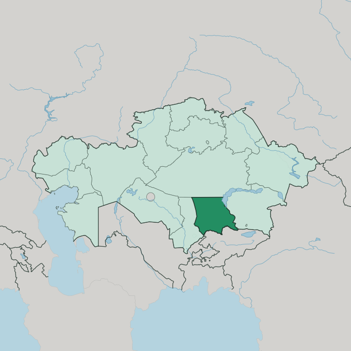
Towns & cities in Zhambyl Oblysy
Pick a town or city — each links to where to stay.
Taraz is where you sleep. The regional capital holds nearly all the beds, and it sits within walking distance of the Karakhan mausoleum and the covered bazaar. West of it, the Aisha Bibi villages scatter through irrigated fields around their famous ornamented tomb, but they keep almost no rooms of their own.
North lie the phosphate towns along the Karatau ridge, worth a day trip toward the range's gorges and the empty Betpak-Dala steppe beyond. You base yourself in Taraz and drive out.
About Zhambyl Oblysy
Taraz anchors the region.
What is Zhambyl Oblysy known for?
The city has traded on the Silk Road for roughly two thousand years, and its Karakhan and Aisha Bibi mausoleums remain the reason most travellers come to southern Kazakhstan at all. Around it spread the terracotta-brick monuments the Karakhanid dynasty left behind. The wider land is a study in contrast: irrigated orchards along the Talas, the black ridges of Karatau to the northwest, and the Muyunkum sands filling the middle.
Farming and phosphate mining pay the bills.
Where is Zhambyl Oblysy?
Zhambyl Oblysy occupies the south of Kazakhstan, a broad band of steppe, sand and mountain running east to west. Kyrgyzstan lies along its southern edge. The Kyrgyz border rides the crest of the Kyrgyz Ala-Too, and the Talas comes down out of those Kyrgyz highlands to cross the region before it thins out and disappears into the Muyunkum sands. Three Kazakh regions ring the rest of it: Turkistan to the west, Almaty to the east, and Karaganda across the north, where the land touches the far southwestern shore of Lake Balkhash.
The shape of the ground changes as you go north. A narrow strip of fertile irrigated land runs along the southern foothills. Above it rise the northern slopes of the Kyrgyz Ala-Too and, further west, the black ridges of Karatau, whose highest point, Bessaz, tops out above two thousand metres.
Then the ground opens out. The sandy Muyunkum desert fills the centre of the region, and the Chu river separates it from the clay flats of Betpak-Dala spreading across the north. It is a big region.
At more than a hundred and forty thousand square kilometres, Zhambyl covers ground on the scale of a small country, most of it dry and thinly settled.
What is Zhambyl Oblysy like?
The region carries its name from a poet. Zhambyl Jabayev, the Kazakh akyn who improvised verse to the two-stringed dombra and lived nearly a hundred years, gave both the region and its former capital name their present form. That inheritance of oral, sung poetry still sits at the centre of how the region pictures itself.
Kazakhs make up the large majority here, but the south has long been a crossroads, and the mix shows it. Russians farm and mine alongside them, and the region holds one of the country's largest Dungan communities, descendants of Hui Muslims who came from China and brought their own cooking and language with them. Turks and Uzbeks add to the blend near the border.
The deep past is Islamic and Karakhanid. Around Taraz stand the brick mausoleums that dynasty raised, the ornamented tomb at Aisha Bibi chief among them, and the ruined palace of Akyrtas sits out on the steppe forty kilometres east, one of five Silk Road sites in the region on the UNESCO World Heritage list. Kazakh and Russian are both spoken.
Markets, mutton and melon season order the year as much as any monument does.
What is the history of Zhambyl Oblysy?
Taraz gives the region its long memory, a caravan stop the Chinese pilgrim Xuanzang called a city of merchants in the seventh century, and the scene of the Battle of Talas in 751 that turned Central Asia toward Islam. Under the Karakhanids it flourished, and its mausoleums date from those centuries. The Mongols levelled it.
Renamed Auliye-Ata under the Kokand khanate, the town fell to the Russian Empire in 1864, and the modern region itself was drawn up as an administrative unit in 1939 and named for the poet Zhambyl Jabayev. The old name, Taraz, was restored in 1997.
What is the climate of Zhambyl Oblysy?
The climate is sharply continental and dry. Winters are long and cold on the open steppe, summers short and fiercely hot, and rain stays scarce across the desert heart of the region all year. The southern foothills below the Kyrgyz Ala-Too catch a little more moisture and hold the snowmelt that feeds the Talas and waters the orchards.
Out on the Muyunkum sands and the Betpak-Dala flats, the ground bakes. Spring, when the steppe briefly greens, is the kindest season to travel.
How do you get to Zhambyl Oblysy?
Taraz has an airport. It runs domestic flights to the big Kazakh cities, and for most travellers that is the way in, though the region also sits on the old rail line and highway that link Almaty in the east with Shymkent and Turkistan to the west. Trains cross the region daily.
The Kyrgyz frontier lies close to the south, an overland option toward Bishkek for anyone continuing across Central Asia. Once here, you need a car for the mausoleums, the Karatau gorges and Akyrtas.
Good for
Updated July 2026