Kazakhstan
Turkistan, Kazakhstan — Towns & Travel Guide


Turkistan is Kazakhstan's southernmost region, on the Uzbekistan border, holding the shrine city of Turkistan and the Syr Darya.
About Turkistan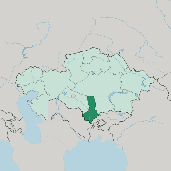
Towns & cities in Turkistan
Pick a town or city — each links to where to stay.
Turkistan itself is the natural base, the regional capital where the pilgrim old town beside the Yasawi mausoleum now backs onto a purpose-built quarter of new hotels. Most trips start there. For the ridge country, Kentau sits under the Karatau within reach of the Sauran ruins, though beds are thin.
Saryagash, down on the Uzbekistan border, draws spa visitors from Tashkent to its mineral springs. Choose the Western Tian Shan foothills near Aksu-Zhabagly if you have come to walk the canyons and the spring tulip meadows.
About Turkistan
One shrine defines this region.
What is Turkistan known for?
The Mausoleum of Khoja Ahmed Yasawi rises over the city of Turkistan, a turquoise-domed Timurid monument that Timur left unfinished at his death and that Kazakh Muslims have walked to for six centuries. The pilgrimage came first. Around it the region spreads south to the Uzbekistan border, watered by the Syr Darya, edged by the Karatau ridge in the north-west and the high Western Tian Shan in the south-east.
Sayram, Otrar, and Kentau ring the capital with ruined Silk Road towns and Soviet mining history.
Where is Turkistan?
Turkistan is the southernmost region of Kazakhstan, its long border running along Uzbekistan to the south. It is one of the country's two smallest regions. The Syr Darya cuts across it from the south-east, the great river of Central Asia flowing north-west out of the Tian Shan on its long, now-diminished journey toward the Aral Sea.
Water is the whole story here. Away from that river and its irrigated floodplain, most of the land is desert: the Kyzyl Kum reaches in from the south-west and the Muyunkum sands lie to the north, so the fields cluster where canals can carry the Syr Darya out onto the plain. The relief tilts at the edges.
In the north-west the Karatau ridge separates the region from the Betpak-Dala steppe, while the south-eastern corner climbs steeply into the Western Tian Shan, where peaks pass 4,300 metres above the desert floor. The city of Turkistan stands on the plain north-west of the region's larger neighbour Shymkent, roughly midway on the old rail line between Kyzylorda to the north and Tashkent across the border to the south. Shymkent, once the regional capital, was split off in 2018 to be governed directly, and the seat moved north to Turkistan.
That move reshaped the map of the south.
What is Turkistan like?
This is Kazakhstan's spiritual south, and faith sits at the centre of its life. The Sufi teacher Khoja Ahmed Yasawi preached here in the twelfth century and was buried in the city that carries the region's name, and his shrine turned Turkistan into a place of pilgrimage that some Central Asian Muslims counted as a second Mecca. Devotion still shapes the calendar.
The population is more mixed than the north of the country, with a large Uzbek community concentrated in the border districts around Sayram, so Uzbek is heard in the bazaars alongside Kazakh and Russian. Cotton, melons, and orchard fruit come off the irrigated land, and the market towns keep the rhythm of an agricultural south. Craft runs old here too.
The birthplace of Yasawi at Sayram, the ruined caravan city of Otrar sacked by the Mongols in 1219, and the walled remains of Sauran all lie within reach of the capital, so the deep past is never abstract. It is a working landscape wrapped around a holy one.
What is the history of Turkistan?
The land far outlives its borders. Its towns grew as staging posts on the northern Silk Road, and Otrar was thriving when Mongol armies destroyed it in 1219. The shrine that made the region came later: Timur ordered the great mausoleum over Yasawi's grave built between 1389 and 1405, and left it unfinished when he died.
The modern region was drawn up in 1932 under Soviet rule and long carried the name of Chimkent, then South Kazakhstan. In 2018 it was renamed Turkistan and its seat moved to the old shrine city.
What is the climate of Turkistan?
Turkistan runs sharply continental, the climate of a place far from any sea. Summers are long, dry, and fierce, with the desert air over the Kyzyl Kum and the Syr Darya plain pushing well past 40 degrees. Winters bite the other way.
Cold spells drop below freezing across the same open ground, and the year brings little rain, so the fields live on canal water rather than the sky. Only the Western Tian Shan in the south-east breaks the pattern, catching snow on its ridges above the parched lowland.
How do you get to Turkistan?
The capital now has its own airport. A greenfield international terminal opened beside the city of Turkistan in 2020 to carry pilgrims and tourists straight to the shrine, ending the old drive up from Shymkent. Rail still matters.
The trunk line that links Kyzylorda in the north with Tashkent across the Uzbekistan border runs through the region, and trains stop at Turkistan on the way. From the south, road crossings from Uzbekistan feed the border towns, while Shymkent's larger airport remains the main gateway for the wider south.
Good for
Updated July 2026