Kazakhstan
Aktyubinskaya Oblast’, Kazakhstan — Towns & Travel Guide


Aktobe Region is the largest region of Kazakhstan, a chromium-and-oil steppe stretching from the Ural foothills toward the Aral basin.
About Aktyubinskaya Oblast’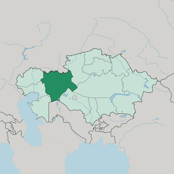
Towns & cities in Aktyubinskaya Oblast’
Pick a town or city — each links to where to stay.
Aktobe is where nearly every visitor sleeps. The city sits where the Kargaly stream flows into the Ilek River, and its hotels cluster along the central avenues near the theatre and the regional museum. Everything else in the region is a day-trip from that base.
Drive south and the settlements thin to railway towns and mining camps. Khromtau exists for its chromite pit, Kandyagash and Emba are junctions on the line, and the white cliffs of the Aktolagai plateau lie hours out across empty steppe with no bed nearby. Base yourself in Aktobe if you want a proper room; treat the deep steppe as an excursion, not a place to overnight.
About Aktyubinskaya Oblast’
What is Aktyubinskaya Oblast’ known for?
Aktobe Region is Kazakhstan's largest region by area, filling the country's western steppe. Ore and oil built it. The chromite mines around Khromtau were the richest in the whole former Soviet Union, and derricks pump crude and gas from fields scattered across the arid plain south of the capital.
Its one real city is Aktobe, the regional capital and a rail junction on the line the Russians once drove from Orenburg toward Tashkent. Beyond the mines and the railway, the land is open pasture.
Where is Aktyubinskaya Oblast’?
Aktobe Region occupies the western part of Kazakhstan, a vast wedge of steppe reaching from the Russian border down toward the deserts of the Aral basin. It is the country's largest region, and one region alone accounts for more than a tenth of all Kazakhstan. Russia's Orenburg province lies along its northern edge, and Uzbekistan's Karakalpakstan touches it far to the south.
Six other Kazakh regions ring the rest. The land itself is not flat everywhere. Down its spine run the Mugalzhar, worn hills that are the last southern remnant of the Ural Mountains before the range dies out into the plain.
They are low. Their crest barely tops a few hundred metres, yet that low ridge is the watershed that splits the Caspian drainage from the Aral, sending rivers off to two different seas. The Emba rises on those slopes and runs about 712 kilometres south-west across the Caspian Depression, the river old geographers drew as the boundary between Europe and Asia.
In the north the Ilek, a tributary of the Ural, waters the country around the capital. Further south the steppe dries into semi-desert, and out in the Bayganin district the Aktolagai plateau lifts white chalk cliffs that were once the floor of a vanished sea. Distances here are enormous and the towns are few.
What is Aktyubinskaya Oblast’ like?
Life in Aktobe Region is shaped by the steppe and by the industry that grew on top of it. Most people here are Kazakh, and Islam is the faith of the majority, but the region also carries a strong Russian imprint left by the fort, the railway and the Soviet mines that built its towns. Kazakh and Russian are both spoken on the street.
The mix is ordinary rather than exotic. Almost all of the region's public culture is concentrated in the capital. Aktobe holds the drama theatre, the regional history museum and the planetarium, and its Soviet-era avenues and post-independence mosques stand side by side.
Away from the city, the older Kazakh world of the steppe still shows through. Herding and horses run deep in a country where families kept moving with the seasons long before the mines arrived, and the memory of that pastoral life sits under the modern industrial surface. It is a working region first.
Visitors come for the emptiness of the land and the plain hospitality of its towns, not for a dense stack of monuments.
What is the history of Aktyubinskaya Oblast’?
The region grew out of a single Russian fort. In 1869 the Empire raised the strongpoint of Ak-Tyube, the "white hill", above the confluence of the Ilek and Kargaly rivers on the caravan road toward Central Asia. Rail followed.
When the Orenburg-Tashkent line reached the town around 1901 it turned a garrison outpost into a junction, and in 1932 the Soviets made Aktobe the seat of a new region carved from the western steppe. Chromite, oil and gas did the rest, drawing mines, refineries and workers to a land that had held only herders before.
What is the climate of Aktyubinskaya Oblast’?
The climate is sharply continental and dry. Winters bite hard on the open steppe, with January settling well below freezing and wind driving across country that has almost nothing to break it, while summers turn hot and dusty as the temperature climbs toward thirty degrees. The Aktobe steppe sees little rainfall.
Barely a few hundred millimetres fall in a year, most of it in spring and autumn, so the grass greens briefly and then burns brown. Spring and early autumn are the kind months to travel.
How do you get to Aktyubinskaya Oblast’?
Nearly everyone arrives through Aktobe. The city has the region's airport and its main railway station, sitting on the old Orenburg-Tashkent line that still carries long-distance trains north into Russia and south across Kazakhstan. Flights link it to the national hubs.
Once you are on the ground, the region is a driving country: highways and rail branches fan out from the capital to Khromtau, Kandyagash and the scattered steppe towns, and reaching the Emba valley or the Aktolagai cliffs means a long haul by road across country where petrol stops are few and far between.
Good for
Updated July 2026