Morocco
Béni Mellal-Khénifra, Morocco — Towns & Travel Guide


Béni Mellal-Khénifra is Morocco's mountain-and-plain interior, where the Tadla plain meets the Middle and High Atlas.
About Béni Mellal-Khénifra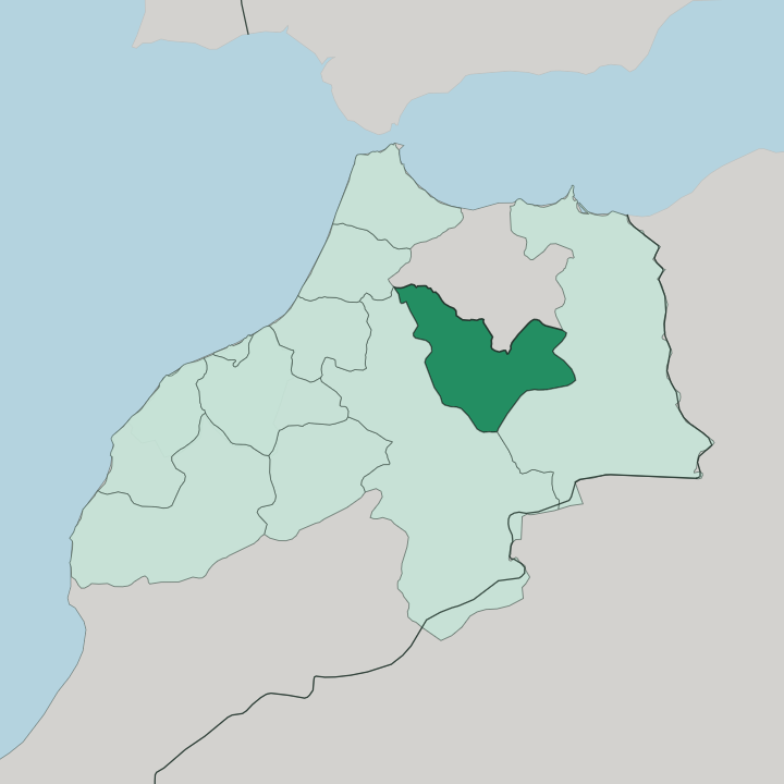
Towns & cities in Béni Mellal-Khénifra
Pick a town or city — each links to where to stay.
Béni Mellal is the obvious base, the regional capital below the Kasbah Ras el-Aïn with the Aïn Asserdoun gardens on its edge. Khénifra suits travellers heading into the cedar forests. Azilal is the road-head for the Ouzoud Falls and the trekking country south of them.
Choose Béni Mellal for a first stay in the region and easy reach of the Tadla plain; choose Khénifra or Azilal when the Atlas mountains are the point of the trip.
About Béni Mellal-Khénifra
What is Béni Mellal-Khénifra known for?
This is one of Morocco's inland regions, away from the coast and the imperial cities. It is a region shaped by its rivers and springs. The Oum Er-Rbia, the country's second-longest river, rises from a cluster of springs in the Middle Atlas and feeds the irrigated Tadla plain that the region farms.
Above the town of Azilal, the Ouzoud Falls drop in stages through a gorge. Springs feed its plains. Béni Mellal, the regional capital, sits below the mountains beside the gardens of the Aïn Asserdoun spring.
Where is Béni Mellal-Khénifra?
Béni Mellal-Khénifra lies in the interior of Morocco, well inland from the Atlantic coast and the country's imperial cities. It sits on a land hinge. The Middle Atlas rises along its northern and eastern edge, the High Atlas walls off the south, and between them spreads the flat Tadla plain.
That plain is the region's farmland, watered by the Oum Er-Rbia and the network of canals drawn off it. The river itself is central to the geography here. It rises from a scatter of springs in the Middle Atlas above Khénifra, runs down past the town, and eventually reaches the Atlantic far to the west at Azemmour.
The Bin el-Ouidane Dam holds back one of its tributaries in a reservoir among the mountains, and the water it stores irrigates the Tadla and turns turbines for power. The region is built from five provinces, the older Tadla-Azilal core joined by Khénifra and Khouribga when the current boundaries were drawn. Béni Mellal, the capital, stands at the foot of the mountains on the plain's southern side.
Azilal lies higher, up in the High Atlas. The Ouzoud Falls drop through their gorge near the village of Tanaghmeilt, in the Azilal country, where the waters gather toward the Oued El Abid and the Oum Er-Rbia beyond. No two corners of the region look quite alike, from irrigated field to cedar ridge to bare rock.
What is Béni Mellal-Khénifra like?
The interior Atlas is Amazigh country, and the Berber presence runs strong through this region. Around Khénifra that heritage has a name of its own. The Zayane are the Berber confederation of the central Middle Atlas, and their tongue, a form of Central Atlas Tamazight, is still the daily language of the mountain villages.
Arabic is spoken alongside it across the towns and the plain. The two threads sit side by side rather than one replacing the other. Life tracks the seasons and the water.
On the Tadla plain the year turns on the olive and citrus harvests drawn from the Oum Er-Rbia's canals, and Béni Mellal is known across Morocco for its olives and its oil. Up in the mountains the rhythm is older, herders moving flocks between summer and winter pasture through the cedar and holm-oak forests of the Middle Atlas. Weekly souks pull the two worlds together.
Craft here means Middle Atlas carpets, silver, and the wood turned from mountain cedar. The food leans on what the land gives, with tagines of the plain's produce and mountain honey. It is a working region rather than a museum one.
Visitors come for the landscape first, and find the culture woven through it.
What is the history of Béni Mellal-Khénifra?
Béni Mellal grew around a fort. In 1688 the Alawi sultan Moulay Ismaïl raised the Kasbah Ras el-Aïn above the spring to guard the Tadla and its water, and the settlement gathered below the walls. The mountains to the east were harder ground for outside rule.
When France pushed into the interior, the Zayane Berbers of the Khénifra country fought back, and the Zaian War that began in 1914 dragged on for years, its sharpest moment the Battle of El Herri near Khénifra that November. As a single administrative region Béni Mellal-Khénifra is recent, drawn in 2015 from the old Tadla-Azilal provinces together with Khénifra and Khouribga.
What is the climate of Béni Mellal-Khénifra?
Height splits the weather in two. Down on the Tadla plain around Béni Mellal the summers run hot and dry, the sun hard on the irrigated fields while the Oum Er-Rbia's canals do the watering. The mountains are another climate entirely.
Up in the Middle Atlas above Khénifra the winters bring real cold and lying snow to the cedar forests, and the summer air stays cool at height. Spring and autumn are the kind seasons across the region, when the plain has not yet baked and the passes are clear.
How do you get to Béni Mellal-Khénifra?
The region sits inland, so most travellers reach it overland. Béni Mellal lies on the roads from Casablanca and Marrakesh, a few hours' drive across the plains, and the town has a small airport of its own. Many arrive as a detour off the Marrakesh run, turning up to the Ouzoud Falls above Azilal before pressing on.
Within the region, roads climb from the Tadla plain into the Middle Atlas and the High Atlas, linking Béni Mellal with Khénifra to the north and the mountain valleys to the south. Buses and shared taxis cover the towns.
Good for
Updated July 2026