Nigeria
Yobe State, Nigeria — Towns & Travel Guide


Yobe State spreads across Nigeria's dry north-east, a land of sandy savanna, cattle markets, and the seasonal Komadugu Yobe river.
About Yobe State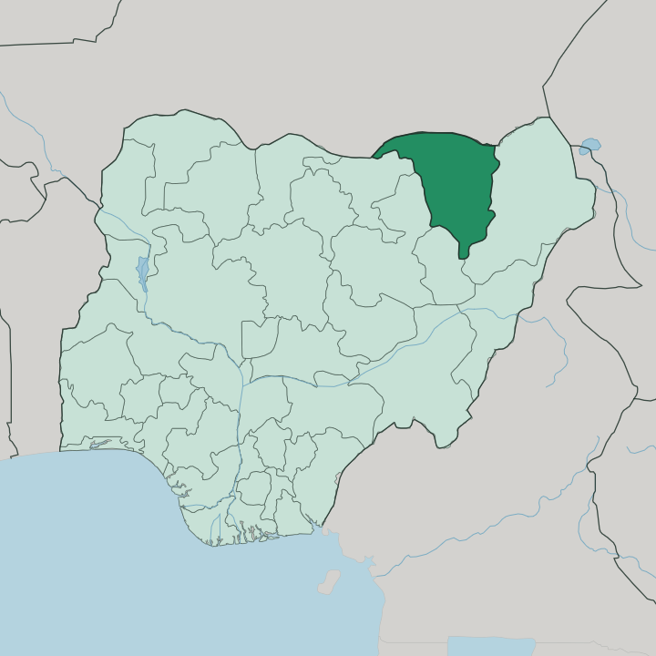
Towns & cities in Yobe State
Pick a town or city — each links to where to stay.
Damaturu is the practical base. It is the capital, and the place where most hotels, offices, and roads converge, so almost every trip through Yobe passes through it at some point. Potiskum, the largest town, suits anyone drawn to its trade and its enormous livestock market.
Out west toward Nguru, the Hadejia-Nguru wetlands pull in migrating birds when the water is high, an hour or so from the capital. Beds thin fast beyond the two main towns. Travellers stage from Damaturu and make day runs to the market at Potiskum or the wetland edges around Nguru.
Choose Damaturu for administration and connections; choose Potiskum when the cattle market or the road south is the point of the trip.
About Yobe State
Yobe is farming and herding country.
What is Yobe State known for?
Its people call it the Pride of the Sahel. Damaturu is the capital, a planned town that grew fast after the state was carved out of Borno in 1991, while Potiskum to the south-west runs one of the largest cattle markets in West Africa. Sorghum, millet, groundnuts, and gum arabic come off the land between them, and the thorn scrub of the far north shades into open desert.
Where is Yobe State?
Yobe sits in Nigeria's dry north-east, one of the country's Sahel states. The Republic of Niger runs along its whole northern border. Borno lies to the east, Gombe to the south-west, Bauchi to the west, and Jigawa off the north-west corner, so the state is landlocked on every side.
Its surface is mostly flat plain. The seasonal Komadugu Yobe river drains the northern half, gathering the run-off and carrying it on toward Lake Chad, while the Gongola drains the country in the south. Vegetation shifts as you move north across the state.
The middle and south are Sudan savanna, open grassland dotted with scattered acacia. Further north that thins into Sahel savanna, then into sandy thorn scrub, and finally into the dune fields near Yusufari where the Sahara begins to press down from the edge of Niger. Water follows the seasons rather than the map.
Along the Komadugu Yobe the floodplain supports irrigated farming and the wetlands near Nguru, but away from the river the land dries hard for much of the year. That contrast between watered floodplain and parched interior shapes where people settle and farm.
What is Yobe State like?
Yobe is a mosaic of Sahel peoples. The Kanuri are the largest group, heirs of the old Bornu court, and Kanuri is heard across most of the state. Fulani herders move cattle over the savanna, and Bade, Ngizim, Karai-karai, Bolewa, and Hausa communities each hold their own towns and dialects.
Islam has shaped the region for centuries, arriving overland with the trans-Saharan trade that ran through Bornu. Faith orders the calendar and the day. Market life is the other pulse of the state, and nowhere shows it like the livestock market at Potiskum, where herders, traders, and drovers converge from across the north.
Craft traditions run to leatherwork, weaving, mat-making, and dyeing, trades tied to the herds and the fields. Music and dance mark weddings, naming ceremonies, and the great Islamic festivals. The cattle economy is not a backdrop here.
It is the thread that ties the towns, the herders, and the markets into one Sahel society stretched along the Komadugu Yobe.
What is the history of Yobe State?
Yobe is a young state on old ground. It was created on 27 August 1991, split from Borno by the federal government of the day. The land itself belonged for centuries to the Bornu Empire, the long-lived Kanem-Bornu state whose rulers controlled the trans-Saharan routes and carried Islam south across the desert into the towns of the north.
Damaturu was raised to capital. From a modest settlement it was built up into the administrative centre of the new state, gathering the roads, offices, and lodgings that a state capital needs. What is now a Nigerian state was long a corner of one of West Africa's most durable empires.
What is the climate of Yobe State?
Yobe runs hot and dry. Its weather turns on two winds off the Sahara. From about November to February the harmattan blows down from the desert, dusty and cool, hazing the sky and dropping the nights.
March through May is the fierce heat, when afternoons on the savanna climb into the low forties. The rains come late and short, roughly from June into September, greening the Komadugu Yobe floodplain before the dryness closes back in. Water is the scarce thing here, not warmth.
How do you get to Yobe State?
Most travellers reach Yobe overland. The state has no coast and no major airport of its own, so arrival means a road journey across northern Nigeria, usually through Bauchi or Gombe to the west and south. Potiskum sits on the trunk road that carries traffic east toward Damaturu and on to Borno, and that highway is the spine of movement through the state.
The border with the Republic of Niger runs along the north but sees little tourist crossing. Inside Yobe, road links the capital with Potiskum, Gashua, Nguru, and Geidam.
Updated July 2026