Romania
Mureş, Romania — Towns & Travel Guide


Mureș is a county in the heart of Transylvania, built around the Mureș river and the medieval citadel of Sighișoara.
About Mureş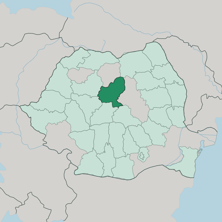
Towns & cities in Mureş
Pick a town or city — each links to where to stay.
Most trips base in Târgu Mureș, the county seat on the Mureș river and the place with the widest choice of rooms and the county's own airport. Sighișoara is the other obvious base. Sleeping inside the walled citadel, a short walk from the Clock Tower and the Vlad Dracul house, puts the medieval town on your doorstep after the day trippers leave.
Sovata suits a slower stay, its hotels ringing the salt-water Bear Lake in the wooded hills to the east. Choose Târgu Mureș for transport and city comforts; choose Sighișoara for the citadel and Sovata for the spa.
About Mureş
What is Mureş known for?
Sighișoara carries the county's fame. Its walled hill town, raised by Transylvanian Saxons in the 12th century, is one of the best-preserved medieval citadels in Europe and the birthplace of Vlad the Impaler. Târgu Mureș, the county seat on the Mureș river, answers it with the ornate Culture Palace and a mixed Romanian and Hungarian street life.
Away from the towns, travellers come for the salt-water Bear Lake at the spa resort of Sovata and the fir forests of the Călimani Mountains. Reghin, further up the valley, has made violins for generations.
Where is Mureş?
Mureș sits in the centre of Transylvania, and the river it is named for runs the length of it. The Mureș, the second-longest river in Romania after the Danube, enters from the north-east and cuts a wide valley west through the county, passing Târgu Mureș on its way. That river valley is the county's spine.
Much of the land belongs to the Transylvanian Plateau, a country of long ridges and broad, deep valleys rather than dramatic peaks. Two more rivers drain the south, the Târnava Mare and the Târnava Mică, whose vine-covered valleys carry the old Saxon villages and their fortified churches. Only in the north-east does the ground rise sharply, into the volcanic Călimani and Gurghiu Mountains that mark the edge of the Eastern Carpathians.
Fir forest covers those slopes. Seven counties ring Mureș. Cluj and Bistrița-Năsăud lie to the north and west, Alba and Sibiu to the south-west, Brașov and Harghita to the south and east, and Suceava touches the mountainous north-eastern corner.
The result is a county of two halves: an open, farmed plateau in the centre and west, and a wall of forested mountains along the eastern rim. Sighișoara stands on a hill above the Târnava Mare in the south. Târgu Mureș holds the middle, where the plateau meets the river.
What is Mureş like?
Three peoples shaped Mureș, and all three are still legible in it. Romanian is the common tongue, but Hungarian is spoken by more than a third of the county, most of all among the Székelys of the eastern hills, where bilingual signs and Hungarian-language schools are ordinary. The third mark is German.
Transylvanian Saxons founded Sighișoara and the fortified Saxon villages along the Târnava valleys, and their steep-roofed houses and church-fortresses still stand even though most of the Saxons themselves have gone. This layering is the county's real subject. That mixed inheritance runs through everyday culture.
Târgu Mureș keeps two theatres, one Romanian and one Hungarian, and its centrepiece, the Culture Palace, is a riot of stained glass and folk-motif tile from the last years of Austro-Hungarian rule. Reghin, up the Mureș valley, is a town of violin workshops whose makers ship their instruments to players abroad, and each summer Sighișoara fills its walled streets with a medieval festival of armour and craft. Food leans central-European.
Sour soups, stuffed cabbage and chimney cake turn up at every fair. The county wears its complications lightly, and that ease is the real pleasure of it.
What is the history of Mureş?
The county's deep past is a frontier story. Transylvanian Saxons and Székelys were settled here in the Middle Ages to guard the kingdom of Hungary's eastern march, and it is they who raised Sighișoara's citadel and the ring of fortified churches across the plateau. For centuries the land lay within Hungary and then Austria-Hungary.
It passed to Romania in 1920 under the Treaty of Trianon, after the First World War redrew the map of Transylvania. The present county was drawn up in its modern form in 1968. Two names have long shared these streets.
What is the climate of Mureş?
Mureș has a continental climate, shut in by the Carpathians. Winters are cold and often snowy, summers warm and green, with the sharpest cold reserved for the Călimani and Gurghiu Mountains along the eastern edge, where fir forest holds the snow late into spring. Down on the Transylvanian Plateau, in the Mureș and Târnava valleys, the weather is milder and the growing season long enough for the vineyards of the Târnave hills.
Rain falls most in early summer. Spring and autumn are the kindest months for walking the citadel at Sighișoara.
How do you get to Mureş?
Târgu Mureș has its own airport, a short drive north-west of the city, though flights are limited and many travellers fly instead into Cluj-Napoca or Sibiu and drive in from the west. Rail is the classic approach. The main line up the Mureș valley links Târgu Mureș, and a second line through the Târnava valley brings the international Budapest-Bucharest trains right under Sighișoara's citadel hill.
Roads climb east from the plateau to Sovata and over the mountains toward the Székely counties. Once you are in, distances are short.
Good for
Updated July 2026