Thailand
Changwat Chai Nat, Thailand — Towns & Travel Guide


Chai Nat is a province of central Thailand on the Chao Phraya, site of the country's first river dam and its largest bird park.
About Changwat Chai Nat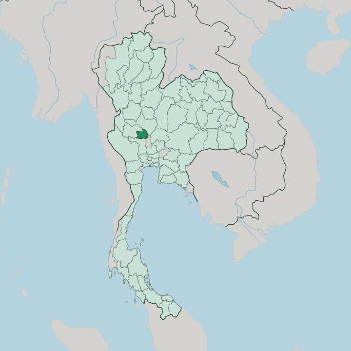


Towns & cities in Changwat Chai Nat
Pick a town or city — each links to where to stay.
Lodging is thin on the ground in Chai Nat. Chai Nat town is the obvious base, the provincial seat on the Chao Phraya, within easy reach of the Chai Nat Bird Park and the Wat Thammamun shrine on its low hill. Sapphaya sits downstream by the dam.
Its old market street keeps a wooden police station more than a hundred years old, one of the province's odd survivals. Choose the town for the dam and the aviary; choose Wat Sing, out on the Tha Chin channel, when you want temples and quiet river country instead.
About Changwat Chai Nat
Chai Nat is farm country.
What is Changwat Chai Nat known for?
The province is best known for the Chao Phraya Dam, the first river barrage built in Thailand, which was completed in 1957 to feed the largest irrigation network in the central plains. Rice paddies stretch in every direction. Its pomelo orchards are prized across the country, and its riverside markets sell the wickerwork and woven cloth the province has long made.
The Chai Nat Bird Park draws the rest, an aviary among the biggest in Asia.
Where is Changwat Chai Nat?
Chai Nat lies in the central plains of Thailand, on the low, flat floor of the Chao Phraya valley. It sits some 188 kilometres north of Bangkok, upstream on the great river that drains the whole heart of the country. Four provinces ring it. Nakhon Sawan is to the north, Sing Buri to the east, Suphan Buri to the south-east, and Uthai Thani to the west.
The land is almost all paddy. Barely a fortieth of the province is forest, and there are no mountains to speak of, only a scatter of low hills like the one under the Wat Thammamun shrine above the river. The rivers make Chai Nat what it is.
The Chao Phraya reaches Chai Nat as a single stream and leaves it divided, the main channel running on toward Bangkok while the Tha Chin branches away to the west toward the Gulf of Thailand. That split is the reason the Chao Phraya Dam stands here, thrown across the river to steady its floods and to fan its water out through the irrigation canals of the plain. Rivers, canals and paddy make the map.
This is a province read by its water, not by its heights.
What is Changwat Chai Nat like?
Chai Nat is quiet, rural and devout. The province calls itself a rice bowl, and the description is plain fact: paddy runs to the horizon on every side, worked much as it has been for generations. Pomelo is the other crop that carries the name of Chai Nat, the sweet khao taengkwa variety grown in the riverside orchards and sold along the roadsides.
Handwork is rooted here as well. Households here are known for wickerwork, for hand-weaving in cotton and silk, and for the painted Benjarong porcelain, its fine floral patterns worked by hand over many firings. Faith shapes the calendar.
The most venerated figure is Luang Pu Suk, a monk of the old school whose amulets are still sought across Thailand, and whose temple, Wat Pak Khlong Makham Thao, stands where the Tha Chin leaves the plain. On a low hill above the Chao Phraya sits Wat Thammamun, its Buddha image old enough to appear on the provincial seal. Everyday speech is Thai.
Between the paddies, the crafts and the shrines, the province keeps a country temper that the capital lost long ago.
What is the history of Changwat Chai Nat?
The name itself means 'place of victory'. Chai Nat rose to importance in the Ayutthaya period, when it served as a forward base against the Burmese armies that pushed down the Chao Phraya toward the capital. The defenders held.
Out of those campaigns came the name the province still carries, and a memory of the wars with Burma that shaped this whole reach of the river.
What is the climate of Changwat Chai Nat?
Chai Nat is hot the year round. The climate is the tropical, monsoon-driven pattern of the central plains, split into three seasons rather than four: a hot spring, a long rainy stretch under the south-west monsoon, and a cooler dry spell after. Rain arrives from the south-west.
Those monsoon rains swell the Chao Phraya each year, which is exactly why the Chao Phraya Dam was built to hold the floods back and ration the water through the dry months. Little of it falls in the cool season.
How do you get to Changwat Chai Nat?
Nearly everyone comes by road. Chai Nat lies about 188 kilometres up the highway from Bangkok, a straightforward run north through the paddy country of the central plains, and buses make the trip through the day from the capital's northern terminal. There is no airport.
The nearest flights land at Bangkok, and from there the road up the Chao Phraya valley is the practical way in, whether by coach or by car.
Updated July 2026