Thailand
Changwat Krabi, Thailand — Towns & Travel Guide


Krabi is a province on the Andaman Sea coast of southern Thailand, known for limestone towers, 154 islands, and beaches like Railay.
About Changwat Krabi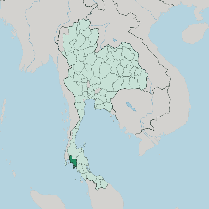


Towns & cities in Changwat Krabi
Pick a town or city — each links to where to stay.
Ao Nang is the usual first base. Longtail boats leave its beach for Railay and the islands, and the strip behind the sand holds most of the province's restaurants and dive shops. Railay trades roads for cliffs.
Ko Lanta stretches long and quiet down the coast, while the Phi Phi Islands pack their beaches and boat traffic onto a pair of steep-sided isles. Krabi town sits inland at the river. Its night market and bus links suit travellers who want a cheaper bed and a quick jump to the piers.
About Changwat Krabi
Limestone is the signature here.
What is Changwat Krabi known for?
Sheer karst towers rise straight out of the Andaman Sea and stand inland above the rubber and oil-palm country, and that vertical rock is what most people picture when they think of Krabi. Climbers come for the cliffs at Railay. Boats fan out from the coast to the Phi Phi Islands and to Ko Lanta, the largest of the province's 154 islands.
The scenery did the rest. Film crews shot beach scenes on Ko Phi Phi Le, and travellers have followed the longtail boats ever since.
Where is Changwat Krabi?
Krabi lies on the Andaman coast of southern Thailand, on the western side of the Malay Peninsula. The Andaman Sea fills its whole western and southern edge. Four provinces ring it on land: Phang Nga to the northwest, Surat Thani to the north, Nakhon Si Thammarat to the east, and Trang to the southeast.
Phuket sits just across the water. The island province faces Krabi across Phang Nga Bay, the broad inlet that both share at their northern corners. Limestone shapes everything.
Tower karst rises straight from the sea and the rice land alike, and the same rock riddles the province with caves, sink-holes, and hidden lagoons reached only by kayak at low tide. Offshore lie 154 islands, among them Ko Lanta and the Phi Phi Islands. Several of those islands and coves fall inside national parks, from Hat Noppharat Thara out to the Phi Phi group.
Inland the ground climbs to Khao Phanom Bencha, the highest mountain in the province, wrapped in rainforest above the rubber and oil-palm estates. The Krabi River gathers those inland waters. It winds down through mangrove forest and empties into the sea beside Krabi town, the low provincial capital at its mouth.
What is Changwat Krabi like?
Two faiths share the coast. Most of Krabi is Buddhist, but a large Muslim minority, roughly a third of the province, gives the fishing villages their mosques, their call to prayer, and much of their cooking. The sea people came first.
Moken and Urak Lawoi communities, the Chao Leh once called sea gypsies, still live along these shores and on the outer islands, working the reefs the way their families always have. Longtail boats, painted and garlanded at the prow, still carry people and catch between the villages and the islands. Inland, the day starts before dawn.
Rubber tappers work the plantations that climb toward Khao Phanom Bencha, and oil palm has spread across the old rice and orchard land in long green rows. Krabi town keeps a different past. Tin money and Chinese traders left shophouses and temples along the river, and the night market still turns out southern curries loud with chilli, turmeric, and shrimp paste.
Thai is the language. The southern dialect runs fast and clipped, and English follows the tourist trade out to Ao Nang and the island piers.
What is the history of Changwat Krabi?
People have lived here since the Stone Age. The cave of Lang Rong Rien held tools and bones tens of thousands of years old, among the earliest human traces in Southeast Asia, and red rock paintings still mark the cliffs around Ao Luek. Old Krabi was called Ban Thai Samor.
It paid tribute to Nakhon Si Thammarat, the kingdom that once ruled this coast, and later drew Chinese miners when tin was found in the hills. King Chulalongkorn made it a town in 1872. The governor later moved the seat to the mouth of the Krabi River, and the province still carries the name of the crossed swords on its seal.
What is the climate of Changwat Krabi?
Krabi runs hot all year. The tropical monsoon splits the calendar in two, and the difference between the seasons is written in the sky and the sea rather than the thermometer. Dry months bring the northeast winds.
From about November to April the skies clear, the Andaman Sea flattens, and the boats run freely to Railay and the islands. Then the southwest monsoon turns the weather around, driving warm rain and heavy swell onto the coast through the middle of the year. Some outer-island boats stop then.
How do you get to Changwat Krabi?
Most arrivals to Krabi come by air. The airport sits just outside Krabi town, an easy hop from Bangkok and a short one from the regional hubs, and it puts the beaches within a taxi ride of the runway. Buses run down the peninsula too.
Roads link Krabi with Phuket and the other southern towns, crossing the ridges and rubber country by coach and minivan. The last stretch is often by water. Ferries and speedboats leave the piers at Ao Nang and Krabi town for Ko Lanta and the Phi Phi Islands, while Railay, cut off by its cliffs, is reached only by longtail boat.
Good for
Updated July 2026