Thailand
Changwat Surat Thani, Thailand — Towns & Travel Guide


Surat Thani is the largest province of southern Thailand, facing the Gulf of Thailand across the islands of Ko Samui, Ko Pha-ngan and Ko Tao.
About Changwat Surat Thani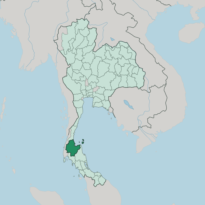


Towns & cities in Changwat Surat Thani
Pick a town or city — each links to where to stay.
Most trips here mean choosing an island. Ko Samui carries the widest range of rooms and the only busy airport, its beaches strung along Chaweng and Bophut, and it makes the easiest first base for a first visit. Ko Pha-ngan sits a short hop north, quieter by day but filling for the full-moon nights at Haad Rin.
Divers head straight for Ko Tao and the reefs off Sairee Beach. On the mainland, Surat Thani town by the Tapi River works mainly as a stop before the Don Sak ferries. Pick the island that fits the trip.
About Changwat Surat Thani
Its fame is offshore.
What is Changwat Surat Thani known for?
Ko Samui, the second-largest island in Thailand, anchors a scatter of Gulf islands that draw most of the province's visitors, with Ko Pha-ngan known for the full-moon gatherings at Haad Rin and Ko Tao for its dive sites. Mu Ko Ang Thong National Park adds a further archipelago of limestone islets north of Samui. Inland, the mainland keeps the rainforest of Khao Sok National Park and long stretches of rubber, oil palm and coconut.
The mix is unusual.
Where is Changwat Surat Thani?
Surat Thani is the largest of the southern Thai provinces, laid out on the western shore of the Gulf of Thailand. The mainland does most of the work. A broad coastal plain runs through the middle, drained by the Tapi River and its tributary the Phum Duang, which join near the coast and empty into the shallow inlet of Bandon Bay behind a fringe of mangrove.
Rubber, oil palm and coconut cover much of this lowland. To the west the land climbs into the limestone hills of the Phuket range, where Khao Sok National Park holds the largest tract of old rainforest in the southern peninsula and the flooded gorges of Cheow Lan Lake. Chumphon lies to the north, Nakhon Si Thammarat to the east, and Krabi over the hills to the south. Then the coast breaks up.
More than a hundred islands lie off the province in the Gulf, and they carry its name abroad. Ko Samui is the largest, the second-biggest island in Thailand after Phuket, with Ko Pha-ngan just north of it and the smaller granite outcrop of Ko Tao further out. West of Samui, the sea forms the tight cluster of Mu Ko Ang Thong National Park, some forty limestone islets rising straight from the water.
The islands sit close enough to reach in a morning, yet each keeps its own character. Water shapes the whole province.
What is Changwat Surat Thani like?
Two provinces live inside one. On the mainland the culture is southern Thai, or Pak Tai, spoken in a quick dialect and built around Theravada Buddhism and the land. Chaiya, in the north, is the old heart of it: the pagoda of Wat Phra Borommathat Chaiya has stood since the Srivijaya centuries, and the forest monastery of Wat Suan Mokkh nearby still draws people to its silent meditation retreats.
Older habits hold too. Farmers here train pig-tailed macaques to twist ripe coconuts from the tallest palms, a practice the province is known for. Chaiya is remembered as well for its salted duck eggs and for Phum Riang silk.
The islands run to a different rhythm. Ko Samui and its neighbours grew from coconut plantations into one of the country's best-known beach destinations, and their culture blends Thai fishing villages with an international crowd. Ko Pha-ngan built a whole scene around the full-moon nights at Haad Rin.
Yet the roots show through. Fishermen still work Bandon Bay, monks still keep the temples, and the rambutan orchards the province is proud of ripen just the same. Food ties it together, from fresh Gulf seafood to the oysters farmed in the bay.
What is the history of Changwat Surat Thani?
The province's story starts at Chaiya. Under the Srivijaya empire, between roughly the eighth and thirteenth centuries, Chaiya was one of the great towns of the peninsula, and some historians argue it was a capital of that maritime realm. Power later drifted to the port of Bandon on the Tapi River.
King Vajiravudh renamed that town Surat Thani in 1915, a phrase meaning the city of the good people, and the name spread to the whole province. Chaiya kept its temples; Bandon kept the trade.
What is the climate of Changwat Surat Thani?
The climate is tropical and monsoon-driven. Heat holds through the year, softened by sea breezes on the islands and the coast. What sets Surat Thani apart is the timing of its rain: the heaviest downpours arrive late, when the north-east monsoon blows in off the Gulf of Thailand from around October into December and peaks in November.
February and March are the dry, bright months, and the hot season runs from March into May. Storms can churn the ferry crossings when the monsoon is at full strength.
How do you get to Changwat Surat Thani?
The islands set the pattern. Two airports serve the province, one on the mainland just outside Surat Thani town and a second on Ko Samui itself, which takes direct flights and spares travellers the ferry. Trains on the Southern Line stop at Phunphin, west of the city, where the overnight service from Bangkok pulls in.
From the mainland, ferries leave the Don Sak piers for Ko Samui and Ko Pha-ngan, with onward boats to Ko Tao. Buses cover the road south.
Good for
Updated July 2026