Thailand
Changwat Pathum Thani, Thailand — Towns & Travel Guide


Pathum Thani is a flat delta province on the Chao Phraya north of Bangkok, the lotus city laced with Rangsit's rice canals.
About Changwat Pathum Thani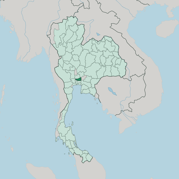


Towns & cities in Changwat Pathum Thani
Pick a town or city — each links to where to stay.
Bangkok is where most travellers actually sleep. They ride north into Pathum Thani for the day and back at night, though the province keeps its own beds too. Rangsit is the busy base.
Its towers and malls crowd around Future Park Rangsit in Thanyaburi, a short hop from Don Mueang and the northern trains. Khlong Luang runs quieter and academic, strung along the canals past Thammasat University and Thailand Science Park. Upstream, Pathum Thani town and Mon-settled Sam Khok sit on the Chao Phraya, where openbill storks still roost in the temple trees.
About Changwat Pathum Thani
Lotus flowers named the province.
What is Changwat Pathum Thani known for?
King Rama II gave the old Mon town of Sam Khok its lotus name, and the flower still sits on the provincial seal. Two things pull visitors north from Bangkok. One is Wat Phra Dhammakaya, the vast golden dome at Khlong Luang that draws crowds of white-clad pilgrims to the largest temple compound in Thailand.
The other is the study belt along the Rangsit canals, where Thammasat University, the Asian Institute of Technology, and Thailand Science Park cluster on the old rice flats.
Where is Changwat Pathum Thani?
Pathum Thani lies on the flat delta of the Chao Phraya, in central Thailand just north of Bangkok. The land is low and almost dead level. The great river runs down through the middle of the province, past the Mon town of Sam Khok and the provincial capital, before it slides on into the capital's sprawl.
There are no hills here and no forest at all, only paddy, orchard, and water. East of the river spreads Thung Luang Rangsit, a broad plain that was open marsh until engineers cut it into a grid. The Rangsit Canal set that pattern.
Dug in the reign of Chulalongkorn, its dead-straight khlong drain the plain in a checkerboard that still orders the fields, the roads, and the towns. Six provinces ring Pathum Thani. Phra Nakhon Si Ayutthaya lies to the north and Saraburi to the northeast, Nakhon Nayok and Chachoengsao to the east and southeast, Bangkok to the south, and Nonthaburi across the river to the west. All that flatness has a cost.
When the Chao Phraya rises, the water has nowhere to go, and the great flood of 2011 drowned the province's rice land and industrial estates for weeks.
What is Changwat Pathum Thani like?
The Mon came first. Fleeing wars in Lower Burma, Mon families settled the river bank at Sam Khok in the seventeenth century, and their descendants still keep the old temples, the swan flags, and the Songkran rites along the Chao Phraya. Lotus gave the province its later name.
When the villagers greeted King Rama II with armfuls of the flower, he renamed their town Pathum Thani, and the bloom has stood on the seal ever since. Mon Buddhism runs deep here. At Wat Phai Lom near Sam Khok, thousands of Asian openbill storks nest in the temple trees each dry season, drawn to the marsh snails of the flooded fields.
Rice and fruit shaped everyday life here. The Rangsit canals grew a famous tangerine, the som Rangsit, and orchards of mango and guava still line the waterways between the paddies. Then the city arrived.
Bangkok's growth pushed north across the boundary, and the old rice flats filled with campuses, factories, and the enormous wholesale market at Rangsit. Two very different crowds share the province. Students pour off the trains for Thammasat University and the Asian Institute of Technology, while white-robed pilgrims flow the other way toward the golden dome of Wat Phra Dhammakaya.
What is the history of Changwat Pathum Thani?
Sam Khok is the old heart of the province. Mon refugees settled the river bank here in the Ayutthaya period, and fresh waves followed as war pushed more of them east out of Burma. The lotus name came in 1815.
King Rama II, received with lotus blooms on a royal visit, renamed the town Pathum Thani, and it was later raised to a full province. The land itself was remade under Chulalongkorn, when a private company cut the Rangsit Canal across the eastern marshes and turned them into some of the kingdom's richest rice fields.
What is the climate of Changwat Pathum Thani?
Pathum Thani runs hot and humid all year. Its tropical climate turns on the monsoon, and the calendar splits into three unequal seasons rather than four. Cool, dry weather settles in from the north between November and February.
Then the heat builds through March and April until the southwest monsoon breaks, and from about May to October warm rain falls in heavy afternoon storms over the flat delta. Flat land drains slowly. When the rains peak and the Chao Phraya runs high together, the water backs up across the paddies and canals of the Rangsit plain.
How do you get to Changwat Pathum Thani?
Pathum Thani sits on Bangkok's northern doorstep, so most people arrive from the capital. Don Mueang, the older of Bangkok's two airports, lies just across the southern boundary, minutes from Rangsit by road. Highways do the rest.
The Phahonyothin road and the parallel tollway run straight up from the city, and the commuter trains of the Red Line now reach Rangsit from central Bangkok. The Chao Phraya offers the slow way in, the same river road the Mon once took upstream to Sam Khok.
Updated July 2026