Thailand
Changwat Saraburi, Thailand — Towns & Travel Guide


Saraburi is a province of central Thailand, holding the Buddha's Footprint shrine at Wat Phra Phutthabat, northeast of Bangkok.
About Changwat Saraburi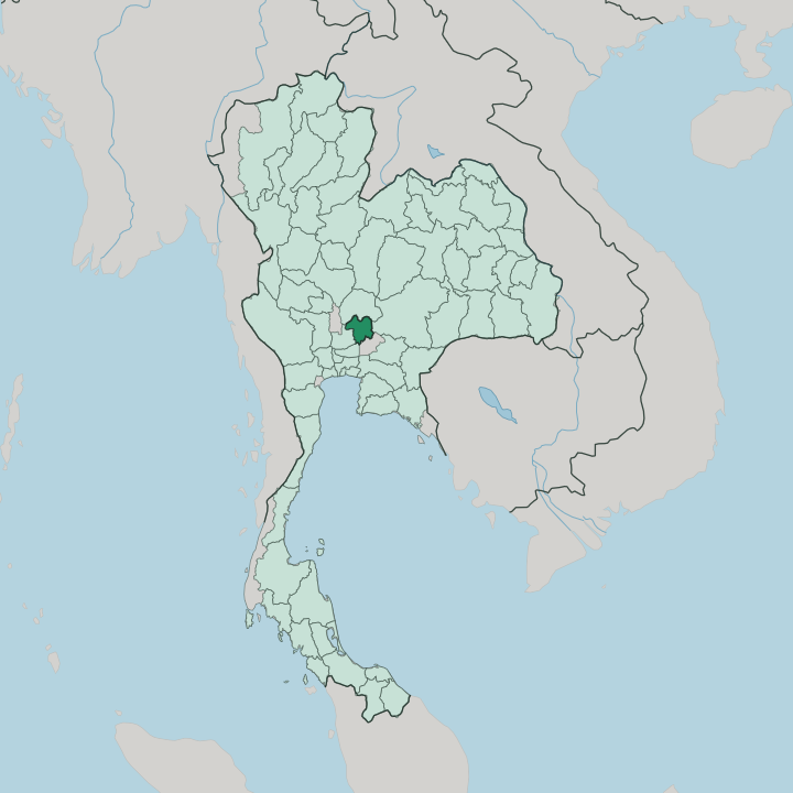


Towns & cities in Changwat Saraburi
Pick a town or city — each links to where to stay.
Most beds cluster in two zones. The provincial capital, Saraburi town, sits on the Pa Sak River and suits travellers who want banks, markets, and the train station close by. For cooler air and resort pools, people head up to Muak Lek on the edge of the Khao Yai hills.
Kaeng Khoi is a railway junction with plain rooms and easy onward trains. Pilgrims who came for the shrine itself stay at Phra Phutthabat, within walking reach of the footprint mondop. Choose by what brought you: temple, forest, or the road east.
About Changwat Saraburi
What is Changwat Saraburi known for?
Two things carry Saraburi's name. Pilgrims know it for Wat Phra Phutthabat, the shrine over a natural hollow in the rock that Buddhists honour as the footprint of the Buddha. The wider country knows it for cement, because the limestone ridges around Kaeng Khoi feed some of Thailand's largest kilns.
Between the quarries lie sunflower fields, the curry-puff stalls of Muak Lek, and the waterfalls of the Khao Yai foothills. It is a working province more than a resort one.
Where is Changwat Saraburi?
Saraburi lies in central Thailand, on the eastern side of the Chao Phraya River basin. The Pa Sak River is its spine, running down from Lopburi in the north and crossing the province before it joins the Chao Phraya system near Ayutthaya. Five provinces ring it.
Lopburi sits to the north, Nakhon Ratchasima to the east, Nakhon Nayok to the southeast, Pathum Thani to the south, and Ayutthaya to the west. Bangkok is a little over 100 km down the road. The land is split in two.
West of the Pa Sak the ground is low, flat rice country, part of the great central plain. East of the river it climbs into high plains, limestone hills, and the wooded ranges that build toward Khao Yai on the Nakhon Ratchasima border. Quarries bite into those limestone ridges around Kaeng Khoi and Phra Phutthabat.
Water is held back upstream behind the Pa Sak Jolasid Dam, the reservoir that steadies the river's flow toward the plain. Three national parks protect the higher ground, among them Namtok Chet Sao Noi with its stepped waterfall. It is a province of edges, where the plain gives way to the hills.
What is Changwat Saraburi like?
Saraburi is a working, farming province at heart, and its rhythms are Buddhist. Almost everyone here follows Theravada Buddhism, and the calendar bends around the temple. The great event is at Wat Phra Phutthabat.
Twice a year the Holy Footprint fairs draw pilgrims from across the country to climb to the gilded mondop and press gold leaf onto the sacred print. In the rains a second rite, the Tak Bat Dok Mai, sees crowds offer wild Dok Khao Phansa blooms to lines of monks, a flower-giving custom that belongs to this province alone. Beyond the shrine, daily life runs on rice, sugarcane, and cement.
Rice paddies fill the western plain. Sugarcane and cassava climb the eastern slopes, and quarry trucks share the roads with them. The limestone ridges above Kaeng Khoi feed some of the country's largest cement plants, and Saraburi wears that heavy industry plainly, without dressing it up for visitors.
In Sao Hai the Tai Yuan, resettled from the far north generations ago, still weave cloth in their old northern manner. Muak Lek adds its own small fame: curry puffs sold hot beside the old highway. Thai is the everyday language, spoken with a central-plains ease.
What is the history of Changwat Saraburi?
Saraburi is a child of war. The Ayutthaya Kingdom carved it out around 1548, in the reign of King Maha Chakkraphat, by joining slices of Lopburi and Nakhon Nayok into one district that could raise soldiers quickly when the capital was threatened. The name pairs sa, an old word for swamp, with buri, meaning town.
Its most famous shrine came later. In 1624 King Songtham founded Wat Phra Phutthabat after a hunter reported a footprint-shaped hollow in the hillside rock, and Ayutthaya's kings made the pilgrimage a royal affair.
What is the climate of Changwat Saraburi?
Saraburi runs hot. It has a tropical savanna climate, split into three plain seasons rather than four. The hot months peak in April, when the central plain bakes and the air over the Pa Sak valley turns heavy.
From May the southwest monsoon brings the rains, and the eastern hills near Khao Yai catch more of them than the flat western paddies. A cooler, drier spell settles in from November. That short cool season is when the pilgrim fairs and sunflower drives fill the roads.
How do you get to Changwat Saraburi?
Most people reach Saraburi by road from Bangkok, a run of about 108 km to the northeast. Two great highways cross here. Phahonyothin Road, Highway 1, comes up from the capital, and Mittraphap Road, Highway 2, begins near the town and strikes out for the northeast.
That junction of routes is the whole point of the place. Trains help too: the northeastern line runs through Kaeng Khoi, where it forks toward Nakhon Ratchasima. There is no airport, so travellers fly into Bangkok first and finish by rail or car.
Good for
Updated July 2026