Democratic Republic of the Congo
Haut Uele, Democratic Republic of the Congo — Towns & Travel Guide


Haut-Uélé is the far north-eastern province of the Democratic Republic of the Congo, named for the Uele River and holding Garamba's savanna.
About Haut Uele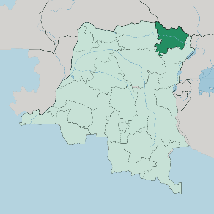


Towns & cities in Haut Uele
Pick a town or city — each links to where to stay.
Isiro is the sensible first base. The former Belgian railway town of Paulis, it keeps the coffee trade, Matari Airport, and the province's steadiest beds. Everywhere else, plan ahead.
Dungu sits at the Uele's headwater junction and is the launch point north into Garamba National Park; Niangara, further up the river, was a Mangbetu court centre known for its carved thrones. Watsa lies east in the old Kilo-Moto gold country. Choose Isiro if you want a room you can count on, and treat the territory towns as staging posts rather than comforts.
About Haut Uele
One name carries.
What is Haut Uele known for?
Garamba National Park spreads its savanna and gallery forest along the South Sudan border, where the last northern white rhinoceros once sheltered and elephants and giraffes still cross the grassland. The province takes its name from the Uele River, whose water threads the whole territory before draining west into the Ubangi. Isiro is the provincial capital and its road-and-air hub.
Beyond it the land is farm and forest, worked by Mangbetu and Zande communities whose art and courts long predate the modern border.
Where is Haut Uele?
Haut-Uélé occupies the far north-eastern corner of the Democratic Republic of the Congo, pressed against the frontier with South Sudan. It is one of four provinces carved out of the old Orientale province, alongside Bas-Uélé to the west, Tshopo to the south-west, and Ituri to the south-east. The land is a mosaic.
Dense equatorial forest holds the southern reaches around Isiro and Wamba, and open savanna spreads north toward the Sudanese border, where Garamba National Park protects the grassland and its rhinos, elephants, and giraffes. The Uele River is the spine of it all. Rising in the east, it runs the length of the province and gathers tributaries like the Dungu and the Bomokandi before flowing west, eventually joining the Ubangi and, through it, the Congo.
Towns line the water. Niangara, Dungu, and Faradje all grew up on the Uele or its branches, using the river for fields, fish, and movement long before any road reached them. Isiro stands inland as the capital, roughly a day and a half's flight and many more days' drive from Kinshasa off in the far west of the country.
What is Haut Uele like?
Two peoples define the province's older character. The Mangbetu built centralised kingdoms along the Uele in the nineteenth century, and their courts became famous for carved harps, anthropomorphic pottery, and a striking tradition of elongated head-shaping. Zande communities spread across the northern grasslands, speaking Pa-Zande and carrying a body of oracle lore that anthropologists studied for decades.
Both traditions still shape village life. Language layers the map. French serves as the administrative tongue and Lingala moves as the trade language, but Pa-Zande, Swahili, and Mangbetu speech fill the markets of Isiro and the river towns.
Coffee has long been the cash crop around the capital, grown on the forest edge and hauled out through Matari Airport when the roads fail, which is often. Life here runs on the river, the field, and the footpath rather than the highway. It is one of the Congo's most remote provinces, and that isolation has kept its craft and custom close to the surface.
What is the history of Haut Uele?
The Mangbetu and Zande kingdoms ruled these rivers before Europeans arrived. Belgian administration reached the Uele late in the nineteenth century, and the town of Isiro grew up around 1934 as Paulis, a rail terminus and coffee depot named for a colonial officer. Gold drew others deeper.
The Kilo-Moto workings near Watsa pulled prospectors far inland. As a formal unit the province is recent, split in 2015 from the former Orientale province and given Isiro as its capital. Its most violent modern chapter came when the Lord's Resistance Army crossed in from the north after 2008.
What is the climate of Haut Uele?
Haut-Uélé runs hot and wet. It sits in a tropical wet-and-dry belt just north of the equator, with average temperatures hovering around the high twenties Celsius through the year. A long rainy season feeds the thick forest and keeps the Uele high, while a shorter dry spell firms the savanna roads north toward Garamba National Park.
Humidity is the constant. Rain, not cold, is what shapes the calendar here, and the wet months routinely turn the province's dirt tracks to mud.
How do you get to Haut Uele?
You fly. Matari Airport, just north-west of Isiro, is the province's main gateway, with intermittent domestic flights that link it to Kisangani and on to Kinshasa off in the far west of the country. The overland alternative is punishing.
Roads are long, unpaved, and slow, and the rains close many of them for weeks at a stretch. Once inside the province, the Uele River and its tributaries still carry local traffic the road network cannot. Reaching Garamba National Park in the north means a further hard drive up from Dungu.
Updated July 2026