Democratic Republic of the Congo
Kasaï-Central, Democratic Republic of the Congo — Towns & Travel Guide


Kasaï-Central is a province of the Democratic Republic of the Congo, centred on Kananga on the Lulua River.
About Kasaï-Central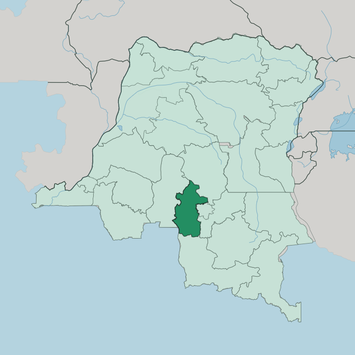


Towns & cities in Kasaï-Central
Pick a town or city — each links to where to stay.
Kananga is the only realistic base, and it holds the province's beds. Everything centres on the capital. Its guesthouses and small hotels cluster in the town near the Lulua River, close to the airport and the administrative offices where most business is done.
The five surrounding territories, Demba, Dibaya, Dimbelenge, Kazumba and Luiza, are rural farming country with almost no formal lodging, so travellers who venture out sleep in Kananga and return. Stay in Kananga if you are coming to Kasaï-Central at all; the rest of the province is a day trip from there, not a place to bed down.
About Kasaï-Central
What is Kasaï-Central known for?
Kasaï-Central sits in the south-central interior of the Democratic Republic of the Congo, well inland from any coast. It takes its name from the Kasai River. Kananga is the anchor.
The province's capital and by far its largest city, Kananga ranks among the four most populous urban areas in the whole country, and nearly everything here runs through it. The land is Congolian forest-savanna, low plateaus of open grassland broken by wooded river valleys. Tshiluba is the language of daily life across the five territories that make up the province.
Where is Kasaï-Central?
Kasaï-Central lies deep in the south-central interior of the Democratic Republic of the Congo, part of the wider Kasai region that gives the province its name. The Kasai River drains this whole country of low plateaus. It is one of the great tributaries of the Congo, and its own tributary the Lulua River runs north through the heart of the province, passing right beside Kananga.
The capital stands just east of the Lulua. The terrain is Congolian forest-savanna, undulating grassland lying at roughly 689 metres above sea level, cut through by gallery forest along the watercourses. Five territories divide the province.
Demba, Dibaya, Dimbelenge, Kazumba and Luiza fan out from Kananga across that rolling savanna, the same ground that once formed the Lulua District of the old Kasaï-Occidental province. The land is entirely landlocked, hundreds of kilometres from any sea in every direction. Rivers, not roads, have long carried the region's trade toward Kinshasa.
That reliance on the Kasai and its tributaries has shaped where towns grew and how goods still move.
What is Kasaï-Central like?
This is Luba country. The Luba-Kasai, or Baluba, form the largest of the peoples here, and their language, Tshiluba, is spoken across the province and serves as one of the national languages of the whole Democratic Republic of the Congo. Alongside them live the Bena-Lulua, the Bakete, the Balwalwa and, toward the north, the Bakuba, whose kingdom is famous for its raffia textiles and carved masks.
The name Kananga itself carries the region's temper. It comes from the Tshiluba word kanangayi, a place for peace or love, recalling the ground where pre-colonial chiefs once gathered to settle treaties and disputes. That memory sits uneasily beside a harder past.
Relations between the Baluba and the Lulua turned violent at the close of the colonial era, and the wider Kasai region has seen conflict flare again in recent decades. Life for most people runs on farming. Cassava, maize and pineapple grow on smallholdings across the territories, and produce moves to Kananga's markets by road and river.
French is the official language, but it is Tshiluba you hear in the street.
What is the history of Kasaï-Central?
The story begins on the Lulua. German explorer Hermann Wissmann founded a station on the left bank of the river and named it Malandji, and when the railway later crossed the water the settlement shifted and took the name Luluabourg from its station. Mobutu Sese Seko renamed it in 1966.
His campaign to strip European names from the map turned Luluabourg into Kananga. The province's borders echo an older one, matching the short-lived Luluabourg Province of 1963 to 1966 and the Lulua District that followed. Kasaï-Central took its present shape in 2015, carved from the split of the former Kasaï-Occidental.
What is the climate of Kasaï-Central?
Kasaï-Central has a tropical climate, warm all year with temperatures hovering around the high twenties Celsius. The calendar splits in two. A long rainy season runs from October to May, when downpours swell the Lulua River and turn the savanna green; a shorter dry season holds from June to September.
Rain shapes travel here as much as anything. Unpaved roads across the five territories turn to mud in the wet months and firm up again once the rains ease off the plateau.
How do you get to Kasaï-Central?
For most visitors, a flight is the way into Kasaï-Central. Kananga Airport is the province's gateway, linked by domestic flights to Kinshasa and other Congolese cities, since the roads inland are long and rough. A railway also serves the capital: the national line runs north-west from Kananga toward the Kasai River port at Ilebo, where cargo transfers to barges bound downstream for Kinshasa.
That river-and-rail route is slow and unreliable. For visitors, flying into Kananga is the practical way in, with road journeys onward to the surrounding territories.
Updated July 2026