Democratic Republic of the Congo
Kwango, Democratic Republic of the Congo — Towns & Travel Guide


Kwango is a savanna province of the Democratic Republic of the Congo, named for the river that marks its border with Angola.
About Kwango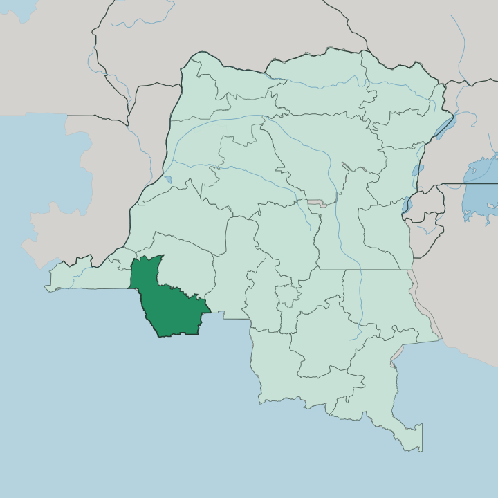


Towns & cities in Kwango
Pick a town or city — each links to where to stay.
Kenge is the practical base in Kwango. For most travellers arriving by road it is the one town in the province with a real choice of beds, and it sits right on National Road 1, the paved artery running down from Kinshasa. Rooms are simple guesthouses.
The territorial seats, Kasongo-Lunda, Feshi, Kahemba and Popokabaka, are administrative centres reached over rough tracks that hold little for a visitor and few places to sleep. Stay in Kenge for a foothold on the highway; venture deeper only with local guides who know the savanna and the river crossings.
About Kwango
What is Kwango known for?
Kwango is one of the newer provinces of the Democratic Republic of the Congo, carved out of the old Bandundu province in 2015. The land is savanna. Grass plains roll toward the horizon, cut by gallery forest along the watercourses and broken here and there by low hills, and the Kwango River threads the western edge as the frontier with Angola.
Kenge is the capital, a road town on the highway out of Kinshasa. The Yaka people give the province much of its identity, known across the country for their carved masks and initiation rites.
Where is Kwango?
Kwango occupies the south-western corner of the Democratic Republic of the Congo, one of the three provinces cut from the former Bandundu when it was split apart in 2015. Angola lies along the south and west. The other edges are Congolese: Kwilu province wraps the north, the district of Kinshasa touches the north-west, Kongo Central sits to the west and Kasaï opens out to the east.
The province spreads across nearly ninety thousand square kilometres of savanna. This is grassland country, not rainforest. The Kwango River gives the province its name and its western spine.
It runs north out of the Angolan highlands, forming the international boundary for part of its course before bending on toward the Kasai River, into which it drains. Its main tributary here is the Wamba, which comes down through the middle of the province from the north. Between those two rivers the land is open plain, threaded with ribbons of forest that follow the water and rise into scattered hills.
Kenge, the capital, stands in the north of the province on the highway from Kinshasa, well away from the Angolan frontier.
What is Kwango like?
The Yaka people are the face of Kwango. They live in the belt of forest and savanna between the Kwango and Wamba rivers, and their carving and masquerade have carried the province's name into museums far beyond the Democratic Republic of the Congo. Their masks are unmistakable.
Raffia-fringed and often crowned with an upturned nose, the Ndeemba masks belong to the n-khanda initiation, the rite that carries boys out of childhood, and they are among the most collected objects of Central African art. Sculpture, drums and basketry round out a strong craft tradition. Oral history traces the Yaka back to conquerors who pushed in from the Lunda plateau in the sixteenth century, and that Lunda strand still runs through the province alongside the related Suku, the Chokwe and others.
Society here is matrilineal, tracing descent through the mother's line. Daily life leans on the land. Households farm cassava, sweet potato and maize on the savanna and add fish from the rivers and game from the bush, the same rhythm that has fed this country for generations.
It is a rural province, and its culture lives in villages far more than in any town.
What is the history of Kwango?
As a province Kwango is young, drawn up in 2015 when the sprawling Bandundu province was broken into three and its old Kwango district was promoted to a province in its own right. Kenge, the district town, became the capital and won city status in the process. The territory itself is far older than the border on the map.
Yaka and Lunda chiefdoms held this ground for centuries, shaped by the sixteenth-century migrations off the Lunda plateau, long before the colonial administration drew districts across the Kwango basin. New province, old country.
What is the climate of Kwango?
Kwango has a tropical savanna climate. The year splits cleanly into two. A long wet season runs from October to May, when thunderstorms green the grasslands and churn the province's dirt roads into deep mud that can swallow a truck to its axles.
The dry months from June to September are the time to travel, with clear skies, firmer tracks and rivers dropping back within their banks. Warmth is constant on these low plains; it is rain, not heat, that marks the calendar here.
How do you get to Kwango?
For most travellers the way into Kwango is National Road 1, the rebuilt highway that runs south-east from Kinshasa and passes straight through Kenge. That road is the province's lifeline, and the paved stretch out of the capital has cut the drive to a matter of hours. Kenge also has a small airport.
Deeper south, toward the Angolan border and the Kwango River, the tarmac gives out and travel means dirt tracks that the wet season can close for days. Come in the dry months, and come by road.
Updated July 2026