Democratic Republic of the Congo
Mongala, Democratic Republic of the Congo — Towns & Travel Guide


Mongala is a rainforest province of northwestern DR Congo, where the Congo River draws the southern edge and Lisala sits above the water.
About Mongala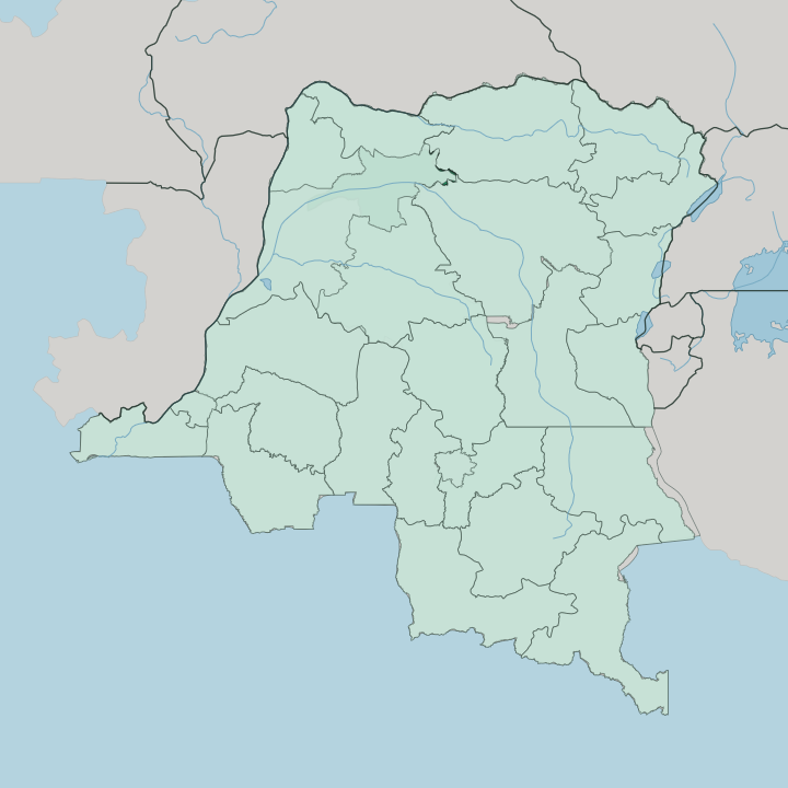


Towns & cities in Mongala
Pick a town or city — each links to where to stay.
Mongala offers little lodging. Almost all of them cluster on the Congo River, simple guesthouses in the two river towns rather than anything grander. Lisala, the capital, is the practical base, a compact place on the bluff above the water with its Cathédrale Saint-Hermès.
Bumba is the other stop. Choose Lisala when you want to be at the seat of the province, or Bumba when you are travelling by barge and following the Congo River itself downstream.
About Mongala
Mongala is river country.
What is Mongala known for?
The Congo River runs along its southern boundary, and the Mongala River that gives the province its name flows down through the forest to meet it. Two towns anchor the province: Lisala, the capital, birthplace of Mobutu Sese Seko, and Bumba, the busy river port a thousand kilometres upstream from Kinshasa. Its northeastern corner holds Yambuku, the village where Ebola was first recorded in 1976.
Beyond those points, it is dense tropical rainforest almost the whole way.
Where is Mongala?
Mongala fills a stretch of the tropical northwest of the Democratic Republic of the Congo, deep in the Congo Basin rainforest. It is inland country, far from any coast. The Congo River draws its whole southern edge, curving in from the west and turning the province's lower boundary into water.
Off that great river, the Mongala River comes down out of the forest from the north as a right tributary of the Congo, and it is this river that names the province. Six provinces ring Mongala on land. Équateur lies to the southwest and Tshuapa to the south, Tshopo to the southeast and Bas-Uele to the east, while Nord-Ubangi sits to the north and Sud-Ubangi to the northwest. The land between these rivers and borders is dense equatorial forest, a broad wedge of the Congo Basin.
Lisala stands on the north bank of the Congo, on a bluff above the water, roughly in the middle of the province's river frontage. Bumba lies downriver of it to the east, the province's other port. Almost everything here is reached by the water rather than the road.
What is Mongala like?
Life in Mongala is life on and around the water. The rivers are the roads, and the dugout canoe is the everyday craft, carrying people, cassava and dried fish between forest villages and the two river towns. Fishing and farming the forest clearings shape the year.
Several peoples share the province. The Ngombe, the Budza and the Mongo are among the larger groups, with Bapoto, Babango and Pagibete communities alongside them across the territories of Lisala, Bumba and Bongandanga. Lingala carries between them.
It is the national language of this stretch of the Congo, the everyday tongue of the river trade, spoken over French even in the markets and on the barges. That river culture reaches well beyond the province. Mobutu Sese Seko, who was born in Lisala and ruled the country he renamed Zaire, made Lingala the language of his army and his rule, so the speech of these forest ports came to sound out across the whole nation.
Music, trade and talk still move along the Congo. The river ties the scattered villages of Mongala together far more than any road does.
What is the history of Mongala?
Mongala is young as a province but old as a district. From 1963 to 1966 the area briefly stood apart as Moyen-Congo, with its own governor, before Mobutu Sese Seko folded it back into the vast Équateur province as the Mongala District. It stayed a district for decades.
Then in 2015 the old Équateur was broken into pieces, and Mongala became a province in its own right, with Lisala raised to its capital. The province still carries the name of the river at its heart.
What is the climate of Mongala?
Heat and rain hold Mongala in every season. Sitting on the equator in the Congo Basin, it has a tropical monsoon climate over most of its ground, with the southern forests near the Congo River shading into a full rainforest climate. Rain falls in every month, heaviest in the two wet seasons, and the air stays humid under the canopy.
Temperatures barely shift from one month to the next. Expect downpours.
How do you get to Mongala?
Reaching Mongala means the river or the air. The Congo River is the province's true highway, and freight barges work the long slow route up from Kinshasa and down from Kisangani, calling at Bumba and Lisala over journeys that can run for weeks. Lisala also has a gravel airstrip, so a light flight from the capital is the quicker way in.
Roads through the rainforest are poor and often impassable. Once here, you travel by water.
Updated July 2026