Democratic Republic of the Congo
Province du Maniema, Democratic Republic of the Congo — Towns & Travel Guide


Maniema is a forested province of eastern Democratic Republic of the Congo, where the Lualaba River carries the young Congo north through Kindu.
About Province du Maniema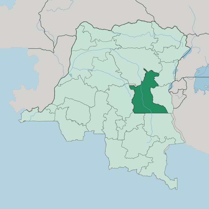


Towns & cities in Province du Maniema
Pick a town or city — each links to where to stay.
Kindu is the practical base. As the provincial capital it is the one point where scheduled flights, the southbound rail line and river boats all meet on the west bank of the Lualaba. Everywhere else is far.
Kasongo sits upriver, the caravan town where Tippu Tip fixed the seat of his trading domain, but the road from Kindu runs two slow, punishing days. Nyangwe lies nearby on the river's right bank, remembered as the limit of David Livingstone's travels. Base yourself in Kindu for anything reached by air, and expect scarce and simple beds once you leave the capital for the old caravan towns upriver.
About Province du Maniema
Maniema is a river province.
What is Province du Maniema known for?
The Lualaba, the headwater name for the Congo, threads its whole length and gathers boats at Kindu, the provincial capital. Long before that, the towns of Nyangwe and Kasongo were the deepest inland reach of nineteenth-century Swahili-Arab ivory and slave caravans, and Kasongo served as the seat of the trader Tippu Tip. That trade left Swahili as the language of daily life across the province.
The land itself shifts from open savanna in the south to dense equatorial forest in the north, all of it part of the wider Congo Basin.
Where is Province du Maniema?
Maniema sits in the east of the Democratic Republic of the Congo, one of the twenty-six provinces the country is divided into. The Lualaba River is its spine. This is the reach where the Congo still travels under its upper name, running south to north through the middle of the province and passing Kindu, the capital, on its way toward Kisangani far downstream.
Kindu stands on the west bank at roughly 500 metres above the sea, a port at the practical head of navigation on that stretch of the river. The land does not stay the same from end to end. In the south it is open savanna and broad river valleys; northward it thickens into high equatorial forest, all of it draining into the Congo Basin.
Along the eastern edge the ground rises. The Mitumba Mountains lift the province toward its borders with North Kivu and South Kivu. Sankuru lies to the west and Tshopo to the north, with Lomami and Tanganyika along the south.
Seven territories fill the map between those borders. Punia, Pangi, Lubutu, Kibombo, Kasongo, Kailo and Kabambare ring the city of Kindu, which stands apart as its own urban district at the centre of it all.
What is Province du Maniema like?
Maniema is Swahili country, and that sets it apart from much of the Congo. The language arrived with the caravans. When Swahili-Arab traders from the coast pushed inland in the nineteenth century and settled at Nyangwe and Kasongo, they brought their tongue and their faith with them, and both took root.
Swahili became the language of the market and the street here, the shared speech of a province where French remains the official one. Islam followed the same routes and left communities that still hold to it. The old trading towns carry that memory in their names and their ruins.
Kasongo, once the seat of Tippu Tip, is remembered as a caravan capital as much as a modern town. The daily rhythm is a river-and-forest one. Fishing and small farming order most lives along the Lualaba, and the forest and mines shape the rest.
It is a quiet, hard-worked province rather than a showy one. Its culture lives in language and river trade more than in monuments.
What is the history of Province du Maniema?
The river towns hold the story. By the mid-nineteenth century Swahili-Arab merchants had reached the Lualaba and built trading stations at Nyangwe and Kasongo, dealing in ivory and slaves far into the interior. Tippu Tip made Kasongo the seat of his domain in 1875.
David Livingstone reached Nyangwe in 1871 and got no further; Henry Morton Stanley set out downriver from there and proved the Lualaba fed the Congo, not the Nile. The Congo-Arab War of the 1890s broke that trading order and folded the province into the colonial Congo Free State.
What is the climate of Province du Maniema?
Maniema is hot and wet. It sits astride the equator in the Congo Basin, so the days stay warm and humid the year round rather than swinging with the seasons. Rain is heavy, and it falls harder over the equatorial forest in the north than over the drier savanna toward the south.
The Lualaba runs full through most of the year on that rainfall. There is no cold season to plan around, only wetter and slightly less wet spells.
How do you get to Province du Maniema?
Flying is how most people reach Maniema. Kindu's airport takes scheduled flights from Kinshasa, Goma and Kisangani, and it is the only quick way in. On the ground the province is a slow one.
Kindu is the northern end of the rail line that runs south toward Kalemie and the mining country, and it remains a working river port on the Lualaba. Roads are rough and the caravan town of Kasongo lies a punishing two days away by track. Come by air, then travel on by rail or river.
Updated July 2026