Democratic Republic of the Congo
Tshuapa, Democratic Republic of the Congo — Towns & Travel Guide


Tshuapa is a rainforest province of the Democratic Republic of the Congo, named for the river that carries its trade to Boende.
About Tshuapa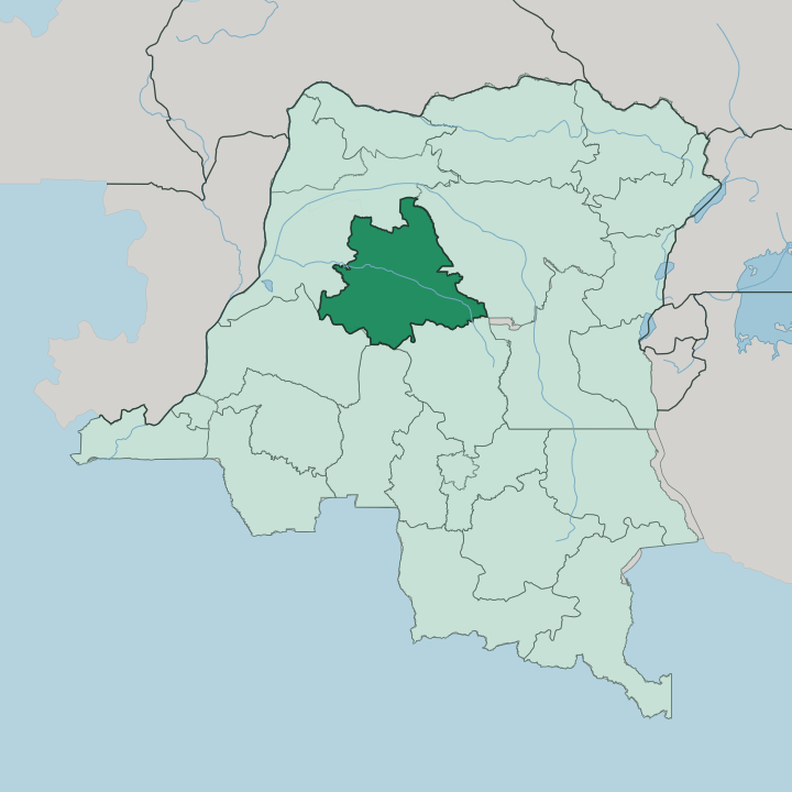


Towns & cities in Tshuapa
Pick a town or city — each links to where to stay.
Boende is the practical base. The capital sits on the Tshuapa River with the province's own airport and its landing for the Kinshasa riverboats, which makes it the natural place for a trip through the province to begin and to end. Deeper in, Monkoto is the jumping-off point for the southern reaches of Salonga National Park, where a bed means a ranger post.
If you want a working river town with a way in and out, choose Boende; if you want the forest itself, plan around Monkoto and expect to rough it.
About Tshuapa
Tshuapa is forest and river, almost nothing else.
What is Tshuapa known for?
The province sits deep in the Congo Basin, its six territories threaded together by the Tshuapa River rather than by roads. Its far south holds part of Salonga National Park, Africa's largest protected block of tropical rainforest and home to a large share of the world's wild bonobos. Boende, the capital, stands on the Tshuapa as a river port.
Travellers who come this far come for the forest.
Where is Tshuapa?
Tshuapa lies in the north-western Democratic Republic of the Congo, in the heart of the Congo Basin, a low and almost roadless expanse of equatorial rainforest that covers roughly 132,940 square kilometres of the country's interior. It is landlocked deep inland. Équateur province borders it to the west, Mongala to the north, and Tshopo to the east, while Sankuru, Kasaï, and Mai-Ndombe lie along its southern edge. The province takes both its name and its shape from the Tshuapa River.
That river rises in the south, near the Sankuru Nature Reserve, and meanders north-west through Bondo and on to Boende. Just west of the capital the Tshuapa meets the Lomela flowing up from the Salonga forest, and the two join to form the Busira River, which carries their combined water on toward the Ruki and finally into the Congo far downstream. Permanent swamp forest lines long stretches of the Tshuapa, flooded year-round.
Roads are few and quickly swallowed by the trees. Here the rivers are the roads, and the map is drawn in water rather than tarmac.
What is Tshuapa like?
The people of Tshuapa are overwhelmingly Mongo, the great forest nation of the central Congo Basin known collectively as the Anamongo. Their homeland is the equatorial forest itself. The Lomongo language they speak is heard across the province, spoken most densely between Boende and the towns along the middle Tshuapa, while French serves as the official tongue and Lingala as the shared national language of the wider Democratic Republic of the Congo.
Life here has always been organised around water and forest rather than around cities. The Mongo are fishers and river traders, and the dugout canoe is as central to daily life as the road is elsewhere, moving cassava and smoked fish and palm oil between villages that face onto the current. Their long oral tradition carries the epic of Lianja, a founding hero-story passed down through generations of storytellers.
Villages string themselves along the riverbanks, not the interior. Clans and lineages, rather than any single old kingdom, hold the society together, a constellation of related groups bound by a shared language and forest way of life. What you find is a culture that reads the forest and the river fluently, and treats both as home.
What is the history of Tshuapa?
Tshuapa as a province is new. It was carved out in the 2015 repartitioning that split the vast old Équateur province into several smaller ones, with Boende raised from district town to provincial capital. The name itself is older, inherited from the Tshuapa District of the Belgian Congo, drawn together in a 1933 reorganisation.
Boende saw the wider violence of independence too: mercenaries fighting the Simba rebellion took the town in January 1964. Salonga National Park, in the south, was first established in 1956 as the Tshuapa National Park before Mobutu redrew its boundaries in 1970.
What is the climate of Tshuapa?
Tshuapa is equatorial and wet. Most of the province has a tropical rainforest climate, hot and humid the year round, with a smaller share tipping into a monsoon pattern of heavier seasonal rain. There is no cold season and little real dry season, only stretches with more or less rain, and heavy afternoon downpours are the rhythm of the calendar.
That constant rain feeds the Tshuapa River and keeps the swamp forest along it flooded for miles. Skies build up, break, and clear again by evening.
How do you get to Tshuapa?
Reaching Tshuapa is slow going. There is no road network worth the name linking it to the rest of the Democratic Republic of the Congo, so most people arrive one of two ways: by air into the airstrip at Boende, or by riverboat. The boats work up the Congo and its tributaries from Kinshasa, passing Mbandaka before turning up the Busira and the Tshuapa to reach the capital, a journey measured in days rather than hours.
Salonga National Park, in the south around Monkoto, has no roads at all and is entered by river. Once you are here, the water is the way through.
Updated July 2026