Chile
Región de Tarapacá, Chile — Towns & Travel Guide


Región de Tarapacá is Chile's desert north, where the Atacama meets the Pacific at the port of Iquique.
About Región de Tarapacá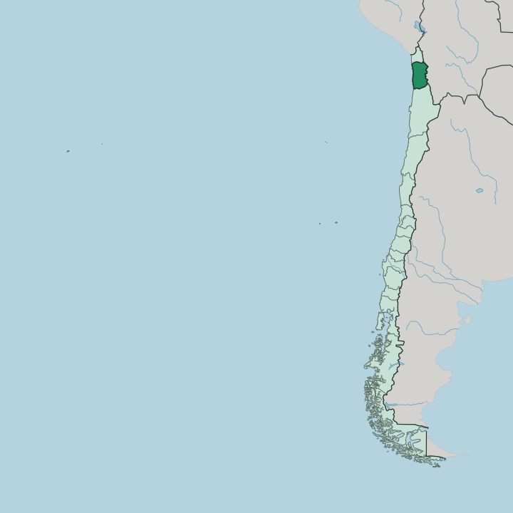
Towns & cities in Región de Tarapacá
Pick a town or city — each links to where to stay.
Almost everyone stays in Iquique. The regional capital is the only real city, and the rest of Tarapacá is desert, oasis, and altiplano, thin on beds and long on distance between them. Base yourself along the Cavancha waterfront for the beach and the restaurants, then drive out to the sights.
Pica makes a quiet second stop, a desert oasis with its limes, its hot springs, and a handful of guesthouses under the palms. Choose Iquique for the coast; choose Pica when you want warm water in the middle of the sand.
About Región de Tarapacá
What is Región de Tarapacá known for?
Tarapacá is one of Chile's northern regions, a stretch of the Atacama Desert running from the Pacific coast up to the Andes. Iquique is the draw. The port city grew rich on saltpeter, and it now spreads along the beach at Cavancha beneath the huge sand dune of Cerro Dragón.
Inland the desert holds the abandoned nitrate works of Humberstone, a UNESCO World Heritage Site, and the green oasis of Pica. The Aymara still herd llamas on the altiplano along the Bolivian border.
Where is Región de Tarapacá?
Tarapacá sits in the far north of Chile, one of the driest inhabited corners of the planet. The Pacific Ocean forms its whole western edge. To the north lies the Arica y Parinacota Region, to the south the Antofagasta Region, and along the east rise the Andes and the Bolivian border.
Ground here climbs in bands as you move inland from the sea. First comes the narrow coast, hemmed in by a coastal range that leaves almost no flat land except at Iquique itself. Behind that range opens the Pampa del Tamarugal, a vast desert plain of the Atacama Desert, once covered in the tamarugo trees that gave it its name.
The pampa is broken by dry ravines and old nitrate camps. East again the ground rises toward the Andes and the altiplano, a high plateau above four thousand metres where salt flats and volcanoes mark the frontier with Bolivia. Water is the rare thing here.
It surfaces at oases like Pica, where springs feed palm groves and lime orchards in the bare desert. The region covers ground about the size of Switzerland, yet nearly all of its people live on the coast at Iquique. The Atacama Desert defines almost everything else.
What is Región de Tarapacá like?
Two very different cultures meet in Tarapacá, the coast and the highlands. Iquique looks out to sea. Its wealth came from saltpeter, and that boom left the port a legacy of Georgian-style timber mansions, a wooden theatre, and the long shaded promenade of Paseo Baquedano through the old town.
The modern city is a beach and duty-free town, drawing surfers, paragliders who launch off the coastal cliffs onto Cavancha, and Chileans down for the shopping. Up on the altiplano the older culture endures. The Aymara have farmed and herded these Andean valleys for centuries, keeping llamas and alpacas, terracing the few watered slopes, and holding festivals that blend Catholic saints with far older mountain rites.
Between coast and mountains lies the desert itself, and the desert keeps its own memory. The nitrate era scattered ghost towns across the Pampa del Tamarugal, and pre-Columbian peoples cut giant geoglyphs into the hillsides that still march across the bare slopes. Spanish is the everyday language, spoken across Chile, though Aymara is still heard in the highland villages.
The three worlds rarely mix, but all three are Tarapacá.
What is the history of Región de Tarapacá?
Tarapacá was Peruvian until 1883. Chile took it at the close of the War of the Pacific, the nitrate conflict fought over these very deserts, and the Treaty of Ancón made the transfer permanent. What followed was the saltpeter boom that built the region.
Companies dug hundreds of nitrate works across the Pampa del Tamarugal, laid railways to the coast, and shipped the fertiliser out through Iquique to the fields of Europe and North America. When synthetic nitrate arrived in the 1920s the trade collapsed, and the desert camps such as Humberstone were left to the sand as ghost towns.
What is the climate of Región de Tarapacá?
Tarapacá is nearly rainless, one of the driest places on Earth. On the coast the Pacific keeps Iquique mild and even all year, wrapped in morning sea fog that burns off by midday. The interior of the Atacama Desert is another matter: scorching by day, cold by night, and in some spots no rain has ever been recorded.
The one exception is the altiplano, where summer storms from the east, the so-called Bolivian winter, bring brief downpours to the high Andes. Sunshine is the constant everywhere below.
How do you get to Región de Tarapacá?
Most visitors fly straight into Iquique. Diego Aracena airport, just south of the city, links Tarapacá to Santiago and the rest of Chile by daily flights across the desert. Overland the region is remote: the Panamericana highway threads down the Pampa del Tamarugal, and mountain roads climb east over the Andes to the Bolivian border crossing at Colchane.
From Iquique the sights are day trips, out to Humberstone and the oasis of Pica by hire car or tour. There is no passenger railway now.
Good for
Updated July 2026