Algeria
Wilaya de Aïn Defla, Algeria — Towns & Travel Guide


Wilaya de Aïn Defla is an Algerian province southwest of Algiers, its Chelif valley set between the Dahra hills and the Ouarsenis.
About Wilaya de Aïn Defla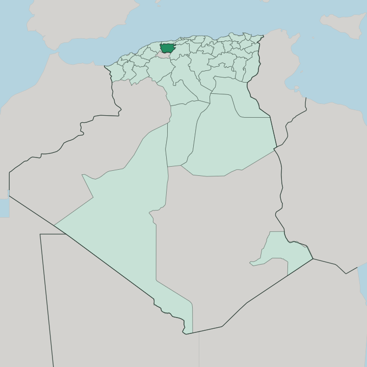


Towns & cities in Wilaya de Aïn Defla
Pick a town or city — each links to where to stay.
The Chelif towns are the bases. Khemis Miliana is the practical choice, the province's largest town and a university seat, sitting where the main road and the Algiers-Oran railway cross the Chelif plain. Miliana suits history.
A walled town on the Zaccar slopes, it keeps Emir Abdelkader's restored house and cherry orchards above the valley. Hammam Righa, up in the hills, is the place for its saline thermal springs, while the capital, Aïn Defla, sits among the orchards and potato fields of the plain.
About Wilaya de Aïn Defla
Farming defines it.
What is Wilaya de Aïn Defla known for?
The province fills a stretch of the Chelif valley, Algeria's longest river threading orchards, vineyards and some of the country's most productive potato land between two mountain walls. Miliana clings to the slopes of Mount Zaccar above the plain, a historic hill town famous for its cherries and its links to Emir Abdelkader. Khemis Miliana, the largest town, anchors the valley with its university and markets.
South of them, the Ouarsenis rises toward the interior; north, the thermal springs of Hammam Righa draw spa visitors.
Where is Wilaya de Aïn Defla?
Wilaya de Aïn Defla lies in northern Algeria, inland and southwest of the capital at Algiers. The province was carved out of Chlef Province in 1984 and covers a broad section of the Tell Atlas, the mountain belt that stretches across the north of the country. Its spine is a valley.
The Chelif threads the middle of it, the longest river in Algeria, draining the interior westward toward the sea past the towns of the plain. North of the water the Dahra massif rises between the plain and the Mediterranean, lifting Mount Zaccar steeply above Miliana. Higher still, the Ouarsenis walls off the south against the plateaux of the interior.
Between the two ranges spreads the fertile Chelif plain. Its floor is farmland. Orchards, cereal fields, vineyards, and the potato beds that supply much of the country line the river and its tributaries.
Chlef borders it to the west, Tissemsilt to the south, Médéa to the east, and Blida and Tipaza sit toward Algiers in the north. Dams along the Chelif and its feeders, among them the Ghrib, hold the winter runoff for the dry summer. The valley floor stays warm and low while the ridges run cooler and wetter, and that split between plain and mountain governs both the farms and the towns strung along the river.
What is Wilaya de Aïn Defla like?
Life here is tied to the land and to a string of old towns above it. The rhythm is rural. Farming villages, weekly souks and orchard country fill the Chelif plain, and the biggest market gives Khemis Miliana its name, khemis means Thursday, the day its market has long been held.
Arabic is the common tongue, with Berber heard alongside it, as across much of northern Algeria. Miliana holds the deepest heritage. Its Ottoman-era medina, spring-fed fountains, and old ramparts crown the Zaccar hillside, and the restored house of Emir Abdelkader, who made the town his base in the 1830s, survives as a municipal museum.
Fruit shapes local identity. Miliana's cherry orchards feed a festival that draws crowds up the mountain each spring, while vineyards, olives, and citrus mark the calendar down on the plain. Faith and learning shaped the towns too.
Miliana produced scholars and holy men whose shrines still draw pilgrims, and Khemis Miliana grew into a university seat on the strength of its markets and schools. Craft, market trade, and a cuisine built on the valley's fruit, grain, and lamb round out daily life. This is farming country first.
What is the history of Wilaya de Aïn Defla?
Its towns are old, its province young. Miliana rose on the Roman colonia of Zucchabar, and Khemis Miliana on Roman Malliana; between 972 and 980 the Zirid prince Buluggin ibn Ziri raised a walled medina on Miliana's ruins. The Ottomans took the town in 1517, and in 1835 Emir Abdelkader made it a stronghold in his war against the French, who seized it in 1842 and rebuilt the valley town below as Affreville.
The wilaya of Aïn Defla itself was carved from Chlef Province only in 1984.
What is the climate of Wilaya de Aïn Defla?
The valley bakes in summer. Shut off from the sea by the Dahra ridge, the Chelif plain turns hot and dry through the long summer, while its winters are mild and carry most of the year's rain. The Ouarsenis and the Zaccar heights stay cooler and wetter than the floor, and snow can dust the higher ground in winter.
That winter rain fills the Ghrib and the other dams that see the farms through the dry months. It is a Mediterranean climate turning semi-arid inland.
How do you get to Wilaya de Aïn Defla?
There is no airport here. Travellers fly into Houari Boumediene Airport at Algiers, then head southwest into the Chelif valley by road or rail. The East-West Highway crosses the length of the province, tracing the valley past Khemis Miliana and El Attaf, and the older RN4 shadows it through the towns.
Trains on the Algiers-Oran line call at Khemis Miliana, the same route the French pushed through to Affreville in 1870. From the capital it is a drive of roughly two hours.
Good for
Updated July 2026