Algeria
Wilaya de Boumerdes, Algeria — Towns & Travel Guide


Wilaya de Boumerdès is a Mediterranean province of Algeria, on the coast just east of Algiers where the Isser reaches the sea.
About Wilaya de Boumerdes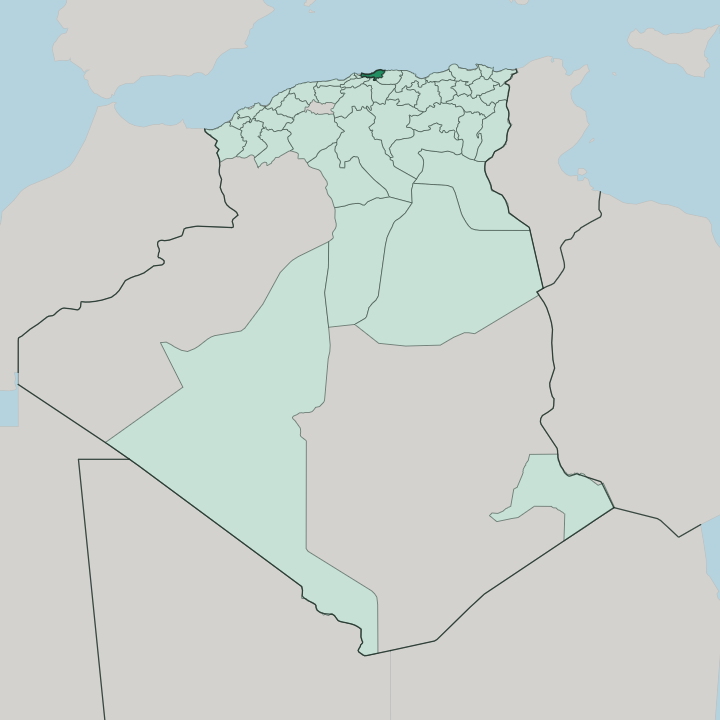


Towns & cities in Wilaya de Boumerdes
Pick a town or city — each links to where to stay.
The capital is the natural base. Boumerdès town sits on the sea, an easy hop east from Algiers, and its seafront corniche and university quarter give it more life than the beach communes further along the coast. Dellys suits travellers who prefer the old fishing harbour and the Casbah to a resort strip.
The sands at Corso and Zemmouri fill up over summer. Inland, Bordj Menaïel makes a quiet stop among the Isser valley orchards.
About Wilaya de Boumerdes
What is Wilaya de Boumerdes known for?
Boumerdès is a slice of Algeria's coast just east of the capital. Its shoreline runs from the beaches at Corso and Zemmouri to the old fishing port of Dellys, whose whitewashed Casbah climbs above an Andalusian medina and a working harbour. The Isser and the Sébaou cut down through the foothills of the Tell Atlas to reach the sea.
Kabyle Berber is spoken across these hills. The capital grew as a planned town around M'Hamed Bougara University, a centre for petroleum and engineering studies, and the province still carries the memory of the 2003 earthquake.
Where is Wilaya de Boumerdes?
Boumerdès stretches along the Mediterranean coast of Algeria, wedged between the capital Algiers to the west and Tizi Ouzou to the east. It belongs to Kabylia, the mountainous Berber region of the country's north. The land is largely upland.
The Tell Atlas throws its northern foothills down to the shore, so the coast alternates between low cliffs, headlands such as Cap Djinet, and pockets of sandy beach. Bouzegza rises inland above the plain. The whole province is compact, one of Algeria's smallest by area.
Two rivers order the interior. The Isser drains the hills and reaches the sea near Zemmouri, while the Sébaou runs off the Kabyle mountains further east toward Dellys. Between the two lies the coastal plain, where most of the towns and the citrus orchards sit.
Boumerdès town, the capital, stands on the shore roughly midway along, at the point the French called Rocher-Noir. Dellys anchors the eastern coast, a Phoenician harbour on a rocky headland. Its western communes have been absorbed into the spread of Greater Algiers, so the province reads as both a seaboard of its own and the eastern flank of the capital's reach.
What is Wilaya de Boumerdes like?
Two languages fill everyday life here. Kabyle Berber carries the hills and the older villages, while Arabic is the language of administration and the coast, and French lingers from the colonial decades. The province sits inside Kabylia, and its people share the Kabyle traditions of the wider region: the weekly souk, the olive harvest, and a strong attachment to village and clan.
Islam shapes the calendar. Zawiyas and old mosques dot the towns, and the religious brotherhoods of Kabylia have long held sway across these valleys. Layers of the past sit close to the surface.
The coast was Phoenician before it was Roman, and the ruins of Rusucurium at Dellys, Cissi at Djinet, and Rusubbicari at Zemmouri still mark those foundations. The capital tells a newer story. Boumerdès was built almost from nothing as a planned town, its grid raised around the hydrocarbons and engineering institutes that became M'Hamed Bougara University, which gives the place a studenty, technical air unusual on this coast.
Fishing boats still work out of Dellys and Cap Djinet, and citrus and vines fill the Isser valley behind the beaches. The 2003 earthquake left its own mark, and much of the rebuilt housing dates from the years after it.
What is the history of Wilaya de Boumerdes?
Boumerdès has been settled since antiquity. Phoenician traders founded the coastal towns of Rusubbicari, Cissi, and Rusucurium, later held by Rome, at what are now Zemmouri, Djinet, and Dellys. Berbers, Arab dynasties, and the Ottomans each ruled in turn.
The modern capital is a French creation, laid out under colonial rule as Rocher-Noir, or Black Rock. The province itself was drawn up in 1984, when Algeria was reorganised into forty-eight wilayas. Then, in 2003, a violent earthquake struck near Zemmouri and flattened swathes of the coast, the deadliest disaster in the province's living memory.
What is the climate of Wilaya de Boumerdes?
Boumerdès has a Mediterranean climate. Summers along the coast are hot and dry, cooled by the sea breeze off the Mediterranean, while the wet season runs through the mild winters when most of the year's rain falls. The Tell Atlas foothills inland catch more of that rain and turn cooler than the shore.
Spring and autumn are the gentle seasons. Green covers the Isser and Sébaou valleys after the winter rains, before the summer dries the hills to gold.
How do you get to Wilaya de Boumerdes?
Boumerdès is reached through Algiers. Houari Boumediene Airport, the country's main international airport at Dar El Beïda, sits just west of the province, a short drive down the coast road. The A1 East-West Highway and the older coastal N24 carry traffic in from the capital.
Rail offers another way into Boumerdès. The Algiers line runs east through Thenia, a junction where the branch for Tizi Ouzou splits off, calling at Boumerdès and Bordj Menaïel.
Good for
Updated July 2026