Algeria
Wilaya de Laghouat, Algeria — Towns & Travel Guide


Laghouat Province runs from the Saharan Atlas and its palm oases down to open desert, anchored by the great Hassi R'Mel gas field.
About Wilaya de Laghouat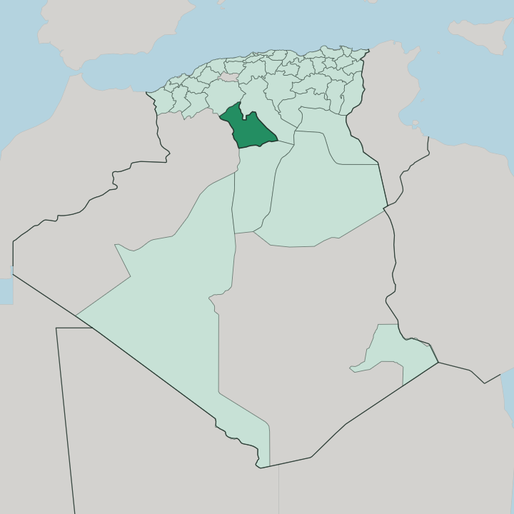


Towns & cities in Wilaya de Laghouat
Pick a town or city — each links to where to stay.
Laghouat is the obvious base, the provincial capital and the main town on the highway between Algiers and the Sahara. Its palm groves line the Oued M'zi. Aflou, up in the Djebel Amour, stays cooler and greener than the desert floor and makes the natural stop for the mountains, while Aïn Madhi draws pilgrims to its Tijaniyya zawiya.
Ksar El Hirane keeps its date gardens just east of the capital. Choose Laghouat first, then range out.
About Wilaya de Laghouat
What is Wilaya de Laghouat known for?
Two things put Laghouat on the map: the palm oasis at its heart and the Hassi R'Mel field, the largest natural-gas deposit in Algeria and one of the biggest in Africa. Sheep matter here too. Millions of head graze the steppe that the Larbaâ and other pastoral tribes have crossed for centuries, between the Saharan Atlas in the north and the desert plateau in the south.
The town of Aïn Madhi draws pilgrims as the birthplace of Ahmad al-Tijani, founder of the Tijaniyya Sufi order. Laghouat is also the last green stop before the deep Sahara on the road down to Ghardaïa.
Where is Wilaya de Laghouat?
Laghouat Province sits on the northern rim of the Sahara, a long day's drive south of Algiers. It occupies the seam between the Saharan Atlas and the open desert. Four provinces ring it: Tiaret along the north, El Bayadh to the west, Djelfa to the east, and Ghardaïa reaching up from the south.
The land falls in three broad bands. In the northwest rise the mountains of the Saharan Atlas, the Djebel Amour, whose ridges climb toward two thousand metres and catch snow in winter. Below them spread the high steppe plains, grazing country for sheep.
Further south the ground flattens into stony desert plateau. Its rivers are wadis, dry most of the year and running only after rain. The Oued M'zi threads through Laghouat and its palm groves before losing itself eastward toward the salt basin of Chott Melrhir, and the headwaters of the Chelif also gather in these mountains.
The Amour Range walls the province on the west; the Monts des Ouled Naïl close it on the east. Laghouat, the capital, stands at the mountains' foot, an oasis strung along the wadi. Aflou lies higher and colder in the Djebel Amour to the northwest.
Off on the southern plateau sits Hassi R'Mel, its gas field piped north across the whole country.
What is Wilaya de Laghouat like?
Faith and the flock shape daily life across the province. Aïn Madhi, a walled town west of Laghouat, gave the world Ahmad al-Tijani, born there in 1737. The Tijaniyya order he founded spread from these dry hills across the Sahara and deep into West Africa, and pilgrims still come to pray at the zawiya that holds his memory.
Most people speak Arabic, with older Berber threads in the mountain villages. Herding runs just as deep. The Larbaâ and other tribes have long moved sheep and goats between the summer steppe and winter shelter, living part of the year under tents of woven wool.
That wool becomes carpets. Laghouat and the surrounding ksour are known for rugs and flat-woven hangings, their patterns handed down through generations of weavers. Life in the oasis turns on the date palm, whose shade lets gardeners grow fruit and vegetables in the sand below.
The province left its mark on European art, too. Eugène Fromentin, the French painter and writer, spent the summer of 1853 at Laghouat and turned the visit into 'Un été dans le Sahara', published in 1857, along with a stream of Orientalist canvases of its caravans and light. His nomads were the Larbaâ.
Their descendants still cross the same ground.
What is the history of Wilaya de Laghouat?
An oasis this useful was never going to be left alone. Caravans and settlers had watered here since at least the 11th century, and the Ottomans brought it under the Beylik of Titteri, ruled from Médéa, in 1786. Resistance to French expansion gathered under Sheikh Moussa Ibn Hassen El Misri from 1831.
It ended in horror. In 1852 French troops besieged and stormed Laghouat, and the massacre that followed killed close to two-thirds of the townspeople, remembered ever since as the Khalya, the emptiness. The fall of Laghouat pushed the M'zab oases to surrender the following year.
What is the climate of Wilaya de Laghouat?
Two climates share the province. Down in Laghouat the desert rules: fierce, dry summers, cold nights, and only a thin ration of rain that mostly falls in winter, with snow effectively unknown on the oasis floor. The mountains tell a different story.
Up in the Djebel Amour around Aflou, the air stays cooler year-round and winter can bury the streets in snow. Rain is scarce everywhere and comes hard when it comes, sending brief floods down the wadis before the ground drinks them dry.
How do you get to Wilaya de Laghouat?
Most visitors come overland. The main approach is the RN1, the trans-Saharan highway, which runs south from Algiers through the steppe and reaches Laghouat before pushing on toward Ghardaïa and the deep desert. The drive takes the better part of a day.
Air Algérie flies into the town's small airport from Algiers. A rail line opened in 2023 runs down from Boughezoul to reach the town from the north. Rougher roads climb west into the Djebel Amour toward Aflou.
Good for
Updated July 2026