Algeria
Wilaya de Bouira, Algeria — Towns & Travel Guide


Wilaya de Bouira spreads across the Kabylia highlands south-east of Algiers, where the Djurdjura wall rises over olive valleys and cereal plains.
About Wilaya de Bouira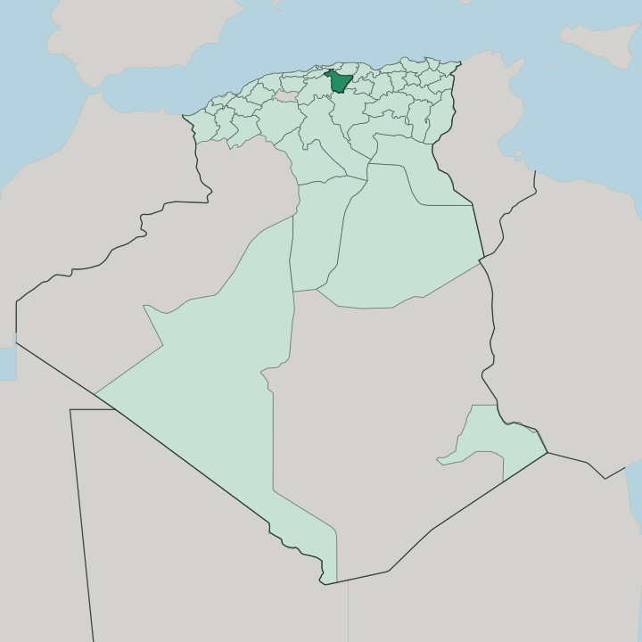


Towns & cities in Wilaya de Bouira
Pick a town or city — each links to where to stay.
Bouira town is the practical base, set on the main road and rail line between Algiers and the east, within reach of both the mountains and the plains. For the Djurdjura itself, the mountain station at Tikjda sits among the cedars and the ski runs. Lakhdaria sits west toward Algiers, where the Oued Isser breaks through its gorges.
Sour El-Ghozlane guards the southern edge, on the site of Roman Auzia. Pick by terrain.
About Wilaya de Bouira
The Djurdjura range defines the province.
What is Wilaya de Bouira known for?
Its limestone wall runs along the northern edge, capped by Lalla Khedidja, the highest summit in the whole Tell Atlas, and much of it falls inside Djurdjura National Park. Cedar forest and karst caves fill the heights, and the mountain station at Tikjda draws hikers in summer and skiers when the snow settles. Below the peaks, silver-grey olive groves and cereal fields cover the valleys around Bouira town.
This is deep Kabylia.
Where is Wilaya de Bouira?
Wilaya de Bouira lies inland from the Mediterranean coast, roughly ninety kilometres southeast of Algiers along the corridor that carries road and rail toward the east. It belongs to Kabylia, the Berber highland region, and sits at its south-western reach. The Djurdjura range walls the province off to the north, a long limestone crest of the Tell Atlas that separates Bouira from Tizi Ouzou beyond.
Lalla Khedidja crowns it. That summit is the highest point of the entire Tell Atlas, and its snows feed the streams that spill down both flanks of the range each spring. Water drains two ways from here.
The Soummam draws part of its headwaters from the province's south, below Mount Dirah, before running northeast toward Béjaïa and the sea, while the Oued Isser drains the western side and cuts past Lakhdaria on its way north to the coast. Between the ranges lie broad valleys of olive and cereal, the working heart of the province around Bouira town. South of the mountains the land flattens and dries into cereal plains and steppe near Sour El-Ghozlane.
It is a province of edges. Mountain, valley and plain sit within an hour of one another.
What is Wilaya de Bouira like?
This is Kabyle country. The people of Bouira are Kabyles, a Berber group whose villages climb the lower Djurdjura in tight clusters of tiled roofs, and their language, Kabyle, is the most widely spoken Berber tongue in Algeria. Arabic is spoken too, especially in the towns and across the southern plains, so the province reads as a seam between Berber highland and Arab lowland.
Olives bind the culture to the land. The autumn olive harvest, the winter pressing of oil, and the old terraced groves matter as much to local identity here as any monument does. Kabylia carries a fierce memory of resistance.
The mountains sheltered the maquis during the war against French rule, and Bouira's forests and ridges were part of that fight. That defiance still shapes local pride, woven together with the long campaign for Berber language recognition that has run through Kabylia for generations. Music travels with it.
Village festivals, poetry sung in Kabyle, and couscous at the centre of every table give the province a texture that owes little to the coast and everything to the mountains behind it.
What is the history of Wilaya de Bouira?
The province is young as an administrative unit, drawn up in 1974 from parts of the old Médéa and Tizi Ouzou departments. The ground beneath it is far older. Sour El-Ghozlane stands on Auzia, a Roman garrison town of Mauretania Caesariensis, and the Djurdjura passes carried Roman, Byzantine, Arab and Ottoman traffic in turn.
The hardest chapter came later. Its mountains were a stronghold of the guerrilla war that ended French rule and won Algeria its independence in 1962.
What is the climate of Wilaya de Bouira?
Bouira has a Mediterranean climate sharpened by altitude and distance from the sea. Summers are hot and dry across the valleys and the southern plains, where the steppe near Sour El-Ghozlane bakes under a high sun. Winters turn cold and wet.
Snow settles for months on the Djurdjura crest, closing high passes and feeding the ski runs at Tikjda, while rain is heavier on the northern slopes than on the drier southern side. Spring and autumn are the kind seasons.
How do you get to Wilaya de Bouira?
Most travellers reach Bouira overland from Algiers, roughly ninety kilometres to the northwest. The A1 East-West motorway runs straight through the province, tying Bouira town to the capital in one direction and to Sétif, Constantine and the whole eastern half of the country in the other. The trunk railway between Algiers and Constantine shadows the same corridor, halting at Bouira and again at Lakhdaria.
No airport serves the province. The nearest runways are at Algiers, and from there the road east finishes the trip.
Good for
Updated July 2026