Greece
North Aegean, Greece — Towns & Travel Guide


North Aegean is a region of scattered Greek islands off the Turkish coast, its capital at Mytilene on Lesbos.
About North Aegean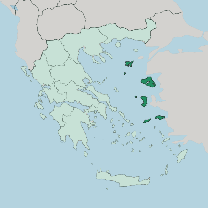
Towns & cities in North Aegean
Pick a town or city — each links to where to stay.
Pick your island first. Lesbos is the largest and the natural base, with Mytilene holding the region's airport and most of its beds. Chios suits travellers who want the mastic villages of the Mastichochoria and a harbour town facing the Turkish coast.
Samos leans green and forested, its vineyards climbing above the port of Vathy while the small resort of Pythagóreio keeps its ancient harbour on the southern shore. Ikaria is for slowing right down. Its longevity and its late-night village festivals are the whole point.
Lemnos stays quietest, low and volcanic, gathered around the small capital of Mýrina.
About North Aegean
This is Greece at the edge of Asia Minor.
What is North Aegean known for?
Its five island groups sit closer to the Turkish shore than to Athens. Lesbos gave the world the poet Sappho, the ouzo distilleries of Plomari, and olive groves that blanket roughly two-fifths of the island. Chios grows mastic.
That aromatic resin, drawn from trees clustered in a handful of southern villages, grows into a marketable crop nowhere else on earth. Samos pours a sweet dessert wine and claims Pythagoras as a native son. Ikaria is stranger still, one of the world's rare Blue Zones where people routinely pass a hundred.
Where is North Aegean?
North Aegean is not one landmass but a spread of islands across the northeastern Aegean Sea, hugging the Turkish coast far more closely than the Greek mainland. The region gathers five regional units: Lesbos, Chios, Samos, Ikaria and Lemnos. Smaller islands hang off each of the big ones.
Psara and the Oinousses lie near Chios, Fournoi near Ikaria, and Agios Efstratios out beyond Lemnos in open water. Between them these islands cover a little under 3,836 square kilometres of land, but the sea does most of the dividing. Distances here are measured in ferry hours, not road miles.
The land itself is rugged and varied. Lesbos, the third largest of all Greek islands, carries olive groves across roughly two-fifths of its surface and shelters the shallow Gulf of Kalloni, a wetland alive with flamingos and migrating birds. Its western end holds the Petrified Forest of Lesbos, where a subtropical woodland was buried under volcanic ash in the Miocene and fossilised standing upright.
Samos rises steep and pine-dark toward its central ridge. Lemnos is flatter and volcanic in origin, its soil good for wine and wheat. Nothing on these islands sits far from salt water.
What is North Aegean like?
Poetry is stitched into these islands. Lesbos raised Sappho and Alcaeus in the sixth century BC, and the modern island still marks the anise scent of Plomari ouzo as a point of pride. The archipelago's culture is a working one, tied to what the land yields.
On Chios the mastic harvest shapes whole villages, the Mastichochoria, whose Genoese-era streets were laid out around the resin trade. Samos ferments its grapes into a fortified sweet wine that has travelled far beyond Greece. Daily life keeps its own clock.
Ikaria is famous for a long-lived, unhurried way of living, its summer panigyria running from dusk until dawn with wine, roast goat and dancing. Greek is the common language across every island, and Orthodox feast days set the rhythm of the year. The region even names its airports after its writers: Mytilene's after the Nobel poet Odysseas Elytis, Chios's after Homer.
Food is honest and local. Olive oil, wild greens, fresh fish and island cheeses carry the table, and the mainland feels a long way off.
What is the history of North Aegean?
These islands have changed hands for millennia. Lesbos flourished as an Aeolian centre in antiquity, home to Sappho and Alcaeus, while Samos rose under the tyrant Polycrates in the sixth century BC as a naval power and the birthplace of Pythagoras. Genoese merchants held Chios and its mastic trade in the Middle Ages, and the Ottomans ruled the whole region for centuries after.
The modern administrative region was drawn up in the 1987 reform of Greek local government, then reshaped in 2010 into its present five regional units. Turkey lies close enough to see on a clear day, and that nearness runs through the region's whole story.
What is the climate of North Aegean?
Summers here run hot and dry. Because these islands lie in the northern reach of the Aegean Sea, their winters turn cooler and wetter than the southern Cyclades, with the odd cold snap and even frost blowing down off the Balkans. The dry season is long, and rain falls mostly between late autumn and early spring.
In July and August the meltemi wind arrives from the north, strong and steady, cooling the beaches and stirring the ferry crossings. Spring greens the hills of Ikaria and Lesbos before the heat sets in.
How do you get to North Aegean?
Getting here takes planning. The islands scatter across open water, so most travellers either fly in or take a long ferry from Athens through the port of Piraeus. Lesbos, Chios, Samos, Ikaria and Lemnos each keep an airport, the busiest being Mytilene's Odysseas Elytis and Chios's Homer field, both linked to Athens year-round.
Overnight ferries from Piraeus reach Mytilene, Chios and Samos in eight to eighteen hours depending on the route and the stops. Once you land, hopping between the islands means another boat. There is no bridge to anywhere.
Good for
Updated July 2026