Hungary
Heves megye, Hungary — Towns & Travel Guide


Heves megye is a county of northern Hungary, running from the Mátra and Bükk peaks down to the Tisza plain around Eger.
About Heves megye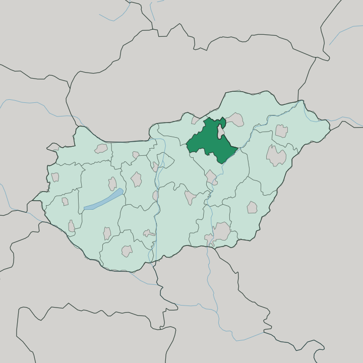
Towns & cities in Heves megye
Pick a town or city — each links to where to stay.
Eger is the obvious base. It is a compact baroque town where the castle, the Egri Bikavér wine cellars of the Szépasszony valley, and the Turkish-era thermal baths all stand within an easy walk. Choose it for a first visit.
Gyöngyös sits at the foot of the Mátra and suits walkers climbing toward Kékes. For water instead of hills, the villages along Lake Tisza put you on the shore of the second-largest lake in the country. Parád and Egerszalók add quiet spa stays.
About Heves megye
Wine and mountains.
What is Heves megye known for?
The county seat, Eger, is a baroque town famous for Egri Bikavér, the red blend known in English as Bull's Blood, and for the fortress where István Dobó held off an Ottoman siege in 1552. North of it rise the Mátra, crowned by Kékes, the highest point in the whole of Hungary. The Bükk range fills the north-east, and Lake Tisza laps the county's southern edge.
Where is Heves megye?
Heves megye occupies a slice of northern Hungary between the mountains and the river. It reaches from high ground in the north to flat plain in the south. Its northern half is mountainous, taking in parts of the two highest ranges in the country, the Mátra and the Bükk, and the Mátra carries Kékes, the highest summit in Hungary.
From those peaks the land falls away southward toward the right bank of the Tisza, where the county flattens into the northern rim of the Great Hungarian Plain. Lake Tisza forms the southern boundary, a broad reservoir created when the Tisza was dammed at Kisköre in 1975 and now the largest artificial lake in the country. The borders are all inland.
Nógrád lies to the west and Pest to the south-west, Borsod-Abaúj-Zemplén wraps the east and north-east around the Bükk, and Jász-Nagykun-Szolnok sits to the south across the plain. Eger, the county seat, stands in the valley of its own small river between the Mátra and the Bükk, and that Eger stream drains south to join the Tisza like the rest of the county's water. No sea comes near.
Everything here tilts from the ridgelines down to the great river.
What is Heves megye like?
Wine sets the tone of the county. The slopes around Eger form one of Hungary's historic red-wine districts, and the Mátraalja vineyards on the southern flank of the Mátra make a second. Egri Bikavér, the blend English speakers call Bull's Blood, is pressed and aged in the tufa cellars that honeycomb the hills outside Eger, and the Szépasszony valley there lines up cellar door after cellar door for tasting.
Beyond the glass, the county trades on its baroque architecture and its spa water. Eger is one of the most complete baroque towns in Hungary, its skyline broken by a minaret left from the Ottoman century. Bathing culture runs alongside the wine.
Mineral and medicinal springs surface at Eger, at Parád, and at Egerszalók, where warm water has built up a pale terrace of salt hills. Hungarian is the everyday language across the county, as it is nationwide. Up in the mountains the culture is quieter and more rural, built around hiking, forest villages, and the long climb to Kékes.
Down on the plain and along Lake Tisza it turns toward water, fishing, and the open horizon of the Great Hungarian Plain. The two halves of Heves megye feel like different countries stitched at Eger.
What is the history of Heves megye?
Eger's fortress carries the county's defining story. In 1552 a garrison under István Dobó held the castle through a thirty-nine-day Ottoman siege while badly outnumbered, and the stand became a national symbol of defiance. That reprieve was temporary.
In 1596 the fortress fell to Sultan Mehmed III, and Eger spent ninety-one years under Ottoman rule, an era that left the minaret still standing in the town. Heves megye in its present form dates to 1950, when Hungary's post-war administrative map was redrawn.
What is the climate of Heves megye?
A continental climate holds across Heves megye. It splits with the terrain. The plain and the Tisza valley in the south run warmer, while the Mátra and Bükk uplands in the north stay cooler and hold their snow later into spring.
Summers are warm across the lowlands, winters cold and often white on the peaks, and rain falls through the year rather than in one wet season. Kékes catches the harshest weather. Altitude, not distance from any sea, drives the difference here.
How do you get to Heves megye?
Most visitors come from Budapest. The capital's Ferenc Liszt airport is the nearest international gateway, and Eger lies about 130 kilometres east of the city. Direct trains run from Budapest's Keleti station to Eger in roughly two hours, while the M3 motorway carries drivers most of the way before a short northward turn onto Route 25.
Gyöngyös and the western Mátra sit closer to Budapest, right beside the M3. Buses fill in the towns the railway skips.
Good for
Updated July 2026