Hungary
Somogy megye, Hungary — Towns & Travel Guide


Somogy megye holds the whole southern shore of Lake Balaton, then rolls south through the forested Zselic hills to the Dráva.
About Somogy megye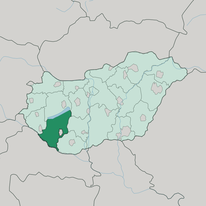
Towns & cities in Somogy megye
Pick a town or city — each links to where to stay.
The lake decides most stays. Siófok is the loud choice, largest of the resorts, with a seventeen-kilometre coast and the thickest cluster of hotels in the whole of the county. Further west along the same south shore, Balatonlelle and Fonyód offer a slower, more family-minded stay by shallow water.
Kaposvár is the inland alternative, the county seat on the Kapos river and the natural base for the Zselic hills. Pick the shore for the beach; pick Kaposvár for forests and towns.
About Somogy megye
The lake is the draw.
What is Somogy megye known for?
The whole south shore of Lake Balaton lies inside Somogy megye, and the county owns the resort strip that most Hungarians picture when they think of a summer by the water. Siófok anchors that strip with a coast running some seventeen kilometres along the lake, backed by hundreds of hotels and a nightlife the north shore never matches. Inland the mood changes completely, from the beach crowds to the quiet forested ridges of the Zselic.
Kaposvár, the county seat, sits well south of the water on the Kapos river.
Where is Somogy megye?
Somogy megye fills a broad slice of south-western Hungary, in the planning region of Southern Transdanubia. Lake Balaton draws its northern edge. The whole southern shore of that lake belongs to the county, and the water itself forms much of the boundary with Veszprém to the north.
The land then falls away southward across roughly a hundred kilometres to the Dráva, the river that runs along the frontier with Croatia. That reach between lake and river is the county in a sentence. Zala lies to the west, while Tolna and Baranya close it off to the east.
Between the two waters the ground is anything but flat. The rolling ridges of the Transdanubian Hills cross the county, and in the south they gather into the Zselic, a block of forested hills averaging a little over two hundred metres. Kaposvár sits in the middle of all this, on the Kapos river, south of the lake and north of the Dráva plain.
Somogy is the most thinly settled county in Hungary, its towns small and its woods and farmland wide. Roughly six thousand square kilometres of it stretch from the beaches down to the Croatian border.
What is Somogy megye like?
Two Somogys share the county. One is the summer world of the Balaton shore, all bathing towns and lakeside promenades that empty out once the warm months pass. The other is the deep, thinly peopled interior of forest, farm and small market town that gives the county its older character.
Kaposvár carries the cultural weight of that inland half. The painter József Rippl-Rónai spent his later years there, and the town keeps his villa and a museum in his name, making it the closest thing Somogy has to an art capital. The county's own name is stitched into that seat: Kaposvár joins Kapos, its river, to vár, the Hungarian word for castle.
Away from the towns the land itself is the attraction. In the Zselic hills the Duna-Dráva National Park runs a starry-sky park, one of the first dark-sky reserves recognised in Europe, where on clear nights the Milky Way stands out over the ridges without a telescope. It is a rural culture.
Hungarian is the everyday language across the whole of Somogy, as it is across the country.
What is the history of Somogy megye?
Somogy is old. It formed as one of the first comitatuses of the medieval Kingdom of Hungary, back in the eleventh century, and Somogyvár grew into a leading religious and secular centre of that early realm. The county even gave its name to a rebel: Koppány, the chieftain of Somogy, rose against Stephen I as the crown pulled the country together around the year 1000.
Later the wars caught it hard, and Ottoman forces seized Kaposvár in 1555 and held the district for well over a century until 1686. The county reached its present borders in 1950. The past here is written into the land more than into monuments.
What is the climate of Somogy megye?
Somogy runs mild and green. The forested Zselic in the south catches a faint sub-Mediterranean influence, which keeps its winters gentle and pulls the annual rainfall a shade above the drier plains to the east. Across the county the yearly average sits close to ten degrees, with something over six hundred millimetres of rain spread through the seasons rather than dumped in one.
The Balaton shore warms fast in summer, which is exactly why the resorts fill from spring to autumn. Snow falls, but rarely lies long.
How do you get to Somogy megye?
Most arrivals come overland from Budapest. A direct train runs from the capital's Keleti station down to Kaposvár in under three hours, and the same rail line threads the Balaton south shore through Siófok, Balatonlelle and Fonyód for the beach towns. The nearest airport is Hévíz-Balaton, sitting just over the western border in Zala, which handles seasonal lake traffic.
Somogy has no coast beyond the lake, so the water reached from here is Balaton, not the sea. Road and rail then fan south from the shore toward Kaposvár and the Dráva.
Good for
Updated July 2026