Kenya
Mandera, Kenya — Towns & Travel Guide




Towns & cities in Mandera
Pick a town or city — each links to where to stay.
Mandera Town holds most of the county's beds, a compact grid of guesthouses and small hotels near the markets and the county offices. It is the practical base. Elwak sits on the southern road up from Wajir, a twin settlement split by the Somali border.
Rhamu and Takaba are smaller river-and-plateau centres to the west, thin on rooms but useful stops toward Ethiopia. Malka Mari National Park has no lodge inside it, so visitors camp beside the Daua, carrying their own gear into the far northern frontier of Kenya.
About Mandera
What is Mandera known for?
Mandera is Kenya's north-eastern frontier, a semi-arid county of Somali pastoralists whose herds of camels, goats and sheep define daily life. Livestock is the wealth here. Its town of the same name sits at the Mandera Triangle, the tri-border point of Kenya, Ethiopia and Somalia, and cross-border trade in animals and goods moves constantly among the three.
Along the Daua River lies Malka Mari National Park, among the least-visited reserves in the country. Few outsiders make the trip.
Where is Mandera?
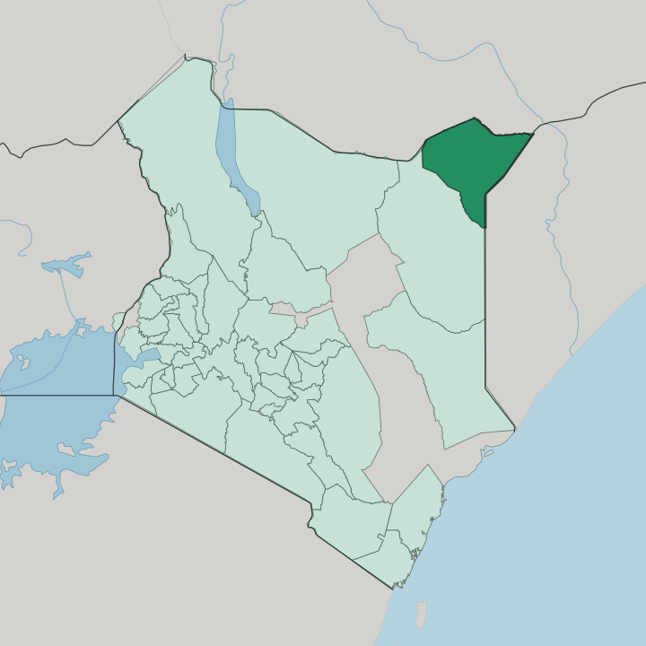
Mandera fills the extreme north-eastern corner of Kenya, the wedge of land pushed furthest toward the Horn of Africa. Ethiopia runs along its northern edge and Somalia along the east, while Wajir County adjoins it to the south and south-west. It is one of Kenya's largest counties and among its most remote.
The land is dry. Low rocky hills sit on plains that climb slowly from the south near Elwak up toward the higher ground along the Ethiopian border. The Daua River is the county's defining line.
Rising in the Ethiopian Highlands, it flows south-east along the whole northern border, the only permanent river in an otherwise parched county, before bending away to join the Jubba River inside Somalia. Its water feeds a thin ribbon of irrigated farms. Onions, citrus, pawpaw and melons grow in these riverside plots, green against the surrounding scrub.
At the Mandera Triangle the three borders converge, and the county's main town stands on the river bank looking across into both Ethiopia and Somalia. Downstream it becomes the Jubba, the river that carries this corner of the Horn's water on toward the Somali coast.
What is Mandera like?
Mandera is Somali country. Almost everyone here belongs to one of the pastoralist clans that have grazed these plains for generations, the Garre most numerous among them, alongside the Degodia, Murulle and Marehan. Islam orders the calendar and the day.
Camels are the measure of wealth, and much of life turns on the herds, moving with the rains between water and pasture. The Garre stand a little apart, part Somali and part Borana, and many of them speak a Cushitic tongue closer to Boran than to Somali. Kinship reaches across the borders.
The same clans live on the Ethiopian and Somali sides of the frontier, and families, herds and trade move between the three countries as easily as clan ties allow. Markets at Mandera Town, Rhamu and Elwak trade camels, goats and imported goods carried in from Somalia and Ethiopia. Oral poetry, recited and memorised, carries the history and law of the clans.
It is a spare, mobile way of life, shaped by drought and distance, and it has kept its own shape far from the reach of the coast and the capital.
What is the history of Mandera?
Mandera has long been a herders' crossroads. Livestock moved between Ethiopia and Somalia along the El Wak road long before a border cut across it. British administrators reached the area from Moyale and made Mandera a district in 1923, a closed frontier zone of the Northern Frontier District sealed off from the rest of Kenya.
Independence did not settle it. The Shifta War of the 1960s, a Somali secessionist revolt, tore through this corner before the fighting subsided. Mandera became a county of its own in 2013, when Kenya's new constitution devolved power to the counties.
What is the climate of Mandera?
Mandera is hot and dry. It ranks among the hottest inhabited parts of Kenya, where the sun beats on bare plains through most of the year and shade is scarce away from the river. Rain is the exception, not the rule.
What falls comes in two short bursts, the long rains around April and May and the short rains toward the end of the year, and both are meagre and unreliable. Drought returns often, and only the Daua River keeps water in the ground when the plains crack and the wells run low.
How do you get to Mandera?
Most people reach Mandera by air. Mandera Airport, on the edge of the town, takes the flights up from Nairobi that spare travellers the overland haul across the north-east. That road is long and rough.
It climbs from Nairobi through Garissa and Wajir over hundreds of miles of dry bush before reaching the county, and the journey takes days rather than hours. Smaller airstrips at Rhamu, Elwak and Takaba serve the outer towns, and the airport at Mandera also sits within reach of Malka Mari National Park.
Updated July 2026