Kenya
Wajir, Kenya — Towns & Travel Guide


Wajir County covers the arid northeastern plains of Kenya, an oasis of ancient rock-cut wells surrounded by Somali camel country.
About Wajir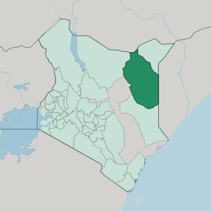


Towns & cities in Wajir
Pick a town or city — each links to where to stay.
Wajir town holds nearly all of the county's lodging, a handful of plain guesthouses clustered near the Orahey Wells and the market. Choices thin out fast. Rooms elsewhere are run for traders and aid workers passing through.
Habaswein anchors the south, on the long road toward Garissa County. Griftu and Bute serve the western and northern grazing lands, but expect little more than a bed and a fan. Stay in Wajir town for any real choice; head out to the trading centres only if the herding country is your reason for coming.
About Wajir
Wajir is desert-well country.
What is Wajir known for?
The town grew around the Orahey Wells, ranks of shafts cut straight down into solid rock that draw a shallow water table to the surface and made a permanent settlement possible in an otherwise dry expanse. Camels, goats and sheep move across the surrounding plains with the seasons, herded by the Somali clans who have grazed this corner of Kenya for centuries. Fort Wajir, a squat colonial garrison, still watches over the old quarter.
Water and livestock define the place.
Where is Wajir?
Wajir County fills a large slice of northeastern Kenya, part of the old North Eastern Province out toward the Horn of Africa. Ethiopia lies along its northern edge and Somalia to the east, so two international borders frame the county. Mandera County sits to the northeast, Garissa County to the south, Isiolo County to the west and Marsabit County to the northwest. It is one of Kenya's largest counties. The land is a near-featureless plain of grey soils, underlain by limestone at its centre, tilting almost imperceptibly upward from the south toward the higher ground in the north.
Water is the whole story of this landscape. There is no permanent river; the seasonal Ewaso Ng'iro only touches the county far to the south, where it loses itself in the reed beds of the Lorian Swamp, one of the largest wetlands in Kenya. Everywhere else, life depends on wells and boreholes.
The Orahey Wells at Wajir town tap a shallow rock aquifer and have watered herds for generations, the reason a town exists here at all. Lake Yahud, a small permanent lake on the town's edge, only appeared after quarrying for the airport runway opened the water table. Beyond the wells, thorn scrub and open grazing run to the horizon in every direction.
What is Wajir like?
Wajir is Somali country, and clan is the frame everything hangs on. Almost everyone here belongs to one of the pastoral Somali clans, the Degodia, Ajuran, Ogaden and Garre, whose elders settle disputes under xeer, the unwritten customary law of the herding society. Islam orders the calendar and the day.
Somali is the language of the market, the mosque and the poem, carried by an oral tradition of verse that ranks a good poet alongside a wealthy herder. Camel milk and meat anchor the table. Livestock is wealth, status and daily work all at once.
Herds of camels, goats and sheep are walked between wells and seasonal pasture, and the portable dome-framed aqal can be struck and reloaded onto a camel in a single morning. Markets in Wajir town trade animals, hides and imported goods trucked up the long roads from the south. The county earned a wider name for the grassroots peace committees its women built to bring feuding clans together, a model outsiders came to study.
Hospitality to a traveller is close to obligatory. Sweet spiced tea comes first, questions later.
What is the history of Wajir?
Long before any border, Somali clans watered their camels at the Wajir wells on their seasonal rounds. The British made it a permanent post in 1912, building Fort Wajir to police the wells and hold the ground of the Northern Frontier District. In the Second World War the fort saw real fighting, bombed by Italian aircraft based in the Horn in 1940 and held by the King's African Rifles.
The district stayed remote for decades. Wajir became a county in its own right in 2013, under the devolution that reshaped Kenya.
What is the climate of Wajir?
Wajir is hot and dry the year round, a semi-arid climate with heat that barely eases between seasons. Rain comes in two short bursts, the long rains from April to June and the short rains from October to December, and even then it is meagre and unreliable. Whole years fall short, and drought recurs, driving herders and their camels toward the permanent Orahey Wells for water.
Between the rains the plains bake and the wells matter most. Shade is the day's currency.
How do you get to Wajir?
Flying is how nearly everyone reaches Wajir. Wajir Airport sits on the edge of town, a single long asphalt strip shared with the Kenya Air Force, and light aircraft link it to Nairobi in under two hours. Small carriers run the route on most days of the week.
The overland alternative is a hard one, hundreds of kilometres of rough road up from Nairobi through Garissa County or Isiolo County, slow and dusty even in the dry season. For most travellers the plane wins easily.
Good for
Updated July 2026