Kazakhstan
Qyzylorda Oblysy, Kazakhstan — Towns & Travel Guide


Qyzylorda Oblysy is Kazakhstan's desert region on the Syr Darya, home to Baikonur and the shrinking Aral Sea.
About Qyzylorda Oblysy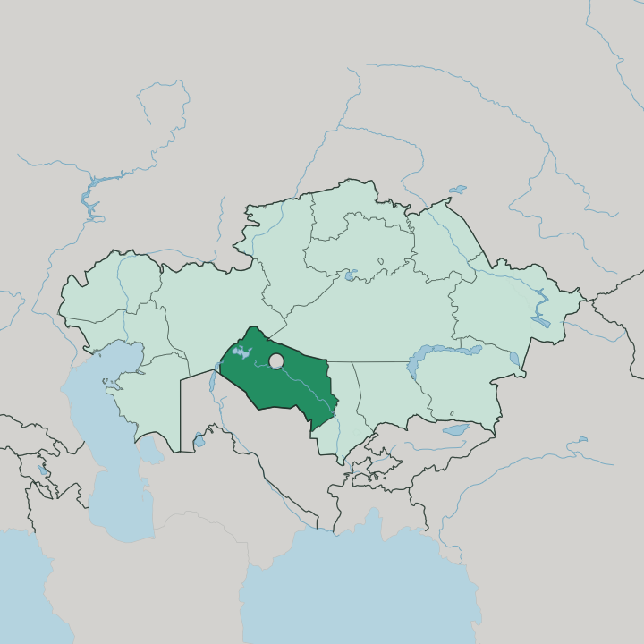
Towns & cities in Qyzylorda Oblysy
Pick a town or city — each links to where to stay.
Qyzylorda, the capital, is the sensible base. It sits on the Syr Darya and holds the region's Regional Museum, whose finds come from the Silk Road ruins at Sygnak and Sauran, and it has by far the widest choice of rooms. Baikonur, the Russian-administered town by the cosmodrome, is the place to be near a launch, though beds there are few and access is controlled.
Aral, the old Aral Sea port with trawlers marooned on sand, is the base for the shrunken shoreline. Choose Qyzylorda if you want one base for the region; choose Baikonur for a launch, or Aral for the sea that left.
About Qyzylorda Oblysy
Two things put this region on the map.
What is Qyzylorda Oblysy known for?
Space and a vanishing sea. One is Baikonur, the cosmodrome that Russia leases and from which the first satellite and the first human spaceflight were launched. The other is the Aral Sea, whose eastern half lies here and whose retreat left dry seabed and stranded fishing boats around the old port of Aral.
Between the two runs the Syr Darya, the river whose diverted water drained that sea and still feeds the rice paddies that make Qyzylorda the country's rice bowl.
Where is Qyzylorda Oblysy?
Qyzylorda Oblysy stretches across the lower Syr Darya in south-central Kazakhstan, on the flat Turan lowland east of the Aral Sea. The river is the region's spine. It enters from the south-east and runs north-west for roughly a thousand kilometres before spilling into what remains of the Aral, and almost everything that lives here clings to its banks.
Beyond that green thread, the land is desert. The Kyzylkum sands press up from the south, one of the largest deserts in the world, while the Aral Karakum and the Lesser Barsuki spread to the north. Only a narrow floodplain along the Syr Darya is farmed; the rest is semi-desert and open sand where little grows.
The northern half of the Aral Sea sits inside the region, its retreat marked by the salt flats and beached hulls around the town of Aral. Uzbekistan lies over the south-western border. Inside Kazakhstan the region meets Aktobe to the north, Ulytau to the north-east, and Turkistan to the south-east.
The capital, Qyzylorda, stands beside the river in the region's south-eastern reach, roughly midway along its course.
What is Qyzylorda Oblysy like?
This is Kazakh country to its core, more so than almost anywhere else in the republic. The people here trace a long line of bards and storytellers who carried the old songs across the steppe. The region claims Korkyt Ata as its own, the philosopher and musician said to have lived on the banks of the Syr Darya, and it is honoured as the birthplace of the kobyz, the two-stringed bowed instrument tied to his name.
A memorial complex raised in his honour rises near Zhosaly. Rice defines the working life. Paddies flood the Syr Darya floodplain, and the local variety carries the Qyzylorda name to tables across the country.
The desert around them is dotted with the ruins of Silk Road towns. Sygnak once served as a caravan capital, and Sauran still shows its double walls to anyone who drives out to it. Older still are the buried settlements of Zhankent and Chirik-Rabat, sunk in the sands far from the river.
History here is a matter of dust and foundations. What survives above ground stands mostly in the museums of the capital.
What is the history of Qyzylorda Oblysy?
The regional capital began as a Kokand fortress, Ak-Mechet, raised on the lower Syr Darya early in the nineteenth century. Russian troops under Perovsky took it in 1853 and renamed it Fort-Perovsky. Its great moment came in 1925, when the town was renamed Qyzylorda, meaning red capital, and made the first capital of the Kazakh Soviet republic.
That capital did not last. It held the role only two years before the government moved on to Almaty, and the oblast itself was drawn up in 1938. Later the Soviet space programme planted Baikonur in its desert, and the same era's irrigation of the Syr Darya set the Aral Sea on its long retreat.
What is the climate of Qyzylorda Oblysy?
The climate is sharply continental. Summers are long, dry and fierce, with July heat pushing well past the mid-thirties over the Kyzylkum sands. Winters swing the other way into hard frost, though the snow that falls stays thin and rarely lasts long on the ground.
Rainfall barely comes. That is why the Syr Darya, not the sky, waters the rice across the floodplain.
How do you get to Qyzylorda Oblysy?
Most travellers arrive at Qyzylorda, which has the region's airport and a station on the main line that carries trains between the west of Kazakhstan and Almaty. The railway threads the whole region, following the Syr Darya through Aral and the smaller river towns, and for many it is the way in and the way around. Flights land in the capital.
Baikonur keeps its own airfield, but access to it is restricted because Russia administers the town. From Qyzylorda a road runs out to the ruins and the receded Aral shore.
Updated July 2026