Mexico
Estado de Colima, Mexico — Towns & Travel Guide


Colima is one of Mexico's smallest states, a strip of Pacific coast between two volcanoes and the port of Manzanillo.
About Estado de Colima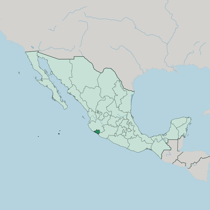


Towns & cities in Estado de Colima
Pick a town or city — each links to where to stay.
Most trips split between Manzanillo on the coast and the capital Colima with its neighbour Villa de Álvarez inland, and those are the two poles of where visitors sleep. Manzanillo is the beach base. Its resorts ring Santiago and Manzanillo bays, with the Moorish domes of Las Hadas marking the smarter end.
Colima suits travellers who want plazas and colonial streets under the volcano rather than sand. Comala lies just up the slope. For surf and quiet, the lime-country beaches near Tecomán stretch south toward the Armería river-mouth.
About Estado de Colima
What is Estado de Colima known for?
Colima packs an outsized range into a small state, from the container cranes of Manzanillo, Mexico's busiest Pacific port, to the snow-streaked cone of Nevado de Colima inland. Two volcanoes anchor the north. The active Volcán de Colima smokes above the valley, one of the most restless peaks in the country.
Comala draws day-trippers for its white houses and red-tile roofs. Tecomán, on the coastal plain, supplies limes to much of Mexico, while divers head far offshore to the Revillagigedo Islands.
Where is Estado de Colima?
Colima sits on Mexico's central Pacific coast. It is one of the country's smallest states, wedged into western Mexico between Jalisco, which wraps around it to the northwest and north, and Michoacán along its eastern edge. The Pacific Ocean forms the whole southern and western side.
Its coastline is short. Barely a sliver of the national coast, it stretches under a hundred miles from the Jalisco line to Michoacán. Inland, the land climbs quickly toward the northern mountains, where the Colima Volcanic Complex marks the western end of the Trans-Mexican Volcanic Belt.
Snow-capped Nevado de Colima, the tallest peak in western Mexico, stands just north of the smoking, restless cone of Volcán de Colima, and most of that massif actually lies over the border in Jalisco. Rivers drain the slopes seaward. The Armería cuts north to south across the middle of the state before reaching the ocean.
Below the mountains the ground flattens into a hot coastal plain around Tecomán and the port of Manzanillo. Far out in the Pacific, hundreds of miles from the mainland, four volcanic specks called the Revillagigedo Islands also belong to Colima, a marine wilderness better known to divers than to map-readers.
What is Estado de Colima like?
Colima's culture runs old and rooted. Long before the Spanish arrived, the shaft-tomb peoples of this coast buried their dead with small burnished-red ceramics, and the plump hairless dogs they modelled have become the emblem of the whole state. These Colima dogs, likenesses of the Xoloitzcuintli, fill museum cases across Mexico.
Archaeologists still open shaft tombs on the valley floor, and the finest figures sit in the capital's museums. The written word matters here too. The village of Comala, all white walls and red-tile roofs at the foot of the volcano, lends its name to the ghost-town setting of Juan Rulfo's novel Pedro Páramo.
Food leans local and unshowy across the state. Cooks turn out sopitos and pork tatemado, and Comala is known for long afternoons of coffee, botana snacks and the chilled chia drink called bate. Ponche flows at the fiestas.
String bands and regional mariachi play through the calendar of village saints' days. On the coast, Manzanillo keeps the harder edge of a working cargo port, a different world from the coffee villages upslope. Craft survives in the mountain pueblos.
Spanish is the everyday language, and daily rhythms still bend around the coffee harvest and the moods of the volcano.
What is the history of Estado de Colima?
Spanish forces under Gonzalo de Sandoval founded a town they called Colima in the year 1523, moving it four years later to the sheltered valley where the capital still stands. It was one of the earliest. Among the first Spanish settlements in western New Spain, Colima held one of the oldest town governments in the country.
For centuries it was a minor district tied to Guadalajara and the wider region of Jalisco. That changed in the mid-nineteenth century, when the Liberals came out on top and Colima was made a state in its own right in 1856.
What is the climate of Estado de Colima?
Colima is hot and tropical. The coast around Manzanillo stays warm and humid through the year, with a wet season from roughly June into October that brings downpours and the odd Pacific hurricane. The winter months are dry and sunny.
Heat eases with height, and the upper slopes of Nevado de Colima hold snow above the warm valleys. Down at the ports and the lime fields the weather stays reliably warm.
How do you get to Estado de Colima?
Most visitors reach Colima by air, flying into the international airport behind the beaches at Manzanillo, which links the coast with Mexico City and a handful of cities across the border. A smaller airport serves the capital. Cruise ships also tie up at Manzanillo, whose harbour doubles as Mexico's busiest Pacific container port.
Overland, a toll highway and a rail line drop down from Guadalajara through Jalisco to the sea. The state is small. After landing, the volcanoes, the capital and the coast all sit within a short drive of one another.
Good for
Updated July 2026