Mexico
Estado de Chiapas, Mexico — Towns & Travel Guide


Chiapas is Mexico's southernmost state, a land of Maya highlands, the Grijalva's Sumidero Canyon, and jungle ruins on the Guatemalan border.
About Estado de Chiapas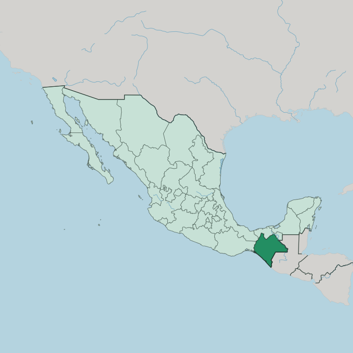


Towns & cities in Estado de Chiapas
Pick a town or city — each links to where to stay.
San Cristóbal de las Casas is the base most travellers choose, a highland colonial town of cobbled streets set among the Tzotzil villages. It holds the widest range of rooms in the state. Palenque suits those who want to wake near the ruins, with jungle lodges strung along the road to the Maya site and howler monkeys overhead.
For the Sumidero Canyon, the riverside town of Chiapa de Corzo beats the state capital of Tuxtla Gutiérrez. Down on the Pacific plain, Tapachula anchors the coffee country of the Soconusco. Pick San Cristóbal first.
About Estado de Chiapas
What is Estado de Chiapas known for?
Chiapas is Mexico's deep south, pressed against Guatemala. Its name travels on two things above all: the Maya. Ancient stone cities like Palenque rise from the Lacandon rainforest, while living Tzotzil and Tzeltal communities fill the highland markets around San Cristóbal de las Casas with wool, incense, and copal smoke.
The Grijalva River has cut the sheer Sumidero Canyon just below Tuxtla Gutiérrez. Coffee grows on the Pacific-facing slopes of the Soconusco. It is Mexico at its most indigenous.
Where is Estado de Chiapas?
Chiapas is the southernmost state in Mexico. It fills the country's far south-eastern corner, pressed against Central America, where Guatemala runs the whole eastern and south-eastern border through jungle and high mountain. Oaxaca lies to the west, Veracruz to the north-west, Tabasco to the north. To the south-west, the land drops to the Pacific Ocean.
Between mountains and sea runs the Soconusco, a hot coastal plain of coffee and banana. Behind that coast rises the Sierra Madre de Chiapas, a chain of peaks topping out at the Tacaná volcano on the Guatemalan line. Inland, the Grijalva River threads the Central Depression, then knifes through the walls of the Sumidero Canyon just past Tuxtla Gutiérrez.
Higher still lie Los Altos, the cool limestone highlands around San Cristóbal de las Casas. These highlands hold the densest cluster of Maya villages, among them Zinacantán and San Juan Chamula. To the north-east the ground falls into the Lacandon rainforest, drained toward the Gulf by the Usumacinta River along the frontier with Guatemala.
Waterfalls such as Agua Azul spill over the limestone shelves between. Little of Chiapas is flat.
What is Estado de Chiapas like?
More indigenous Maya people live in Chiapas than in any other Mexican state. Their languages are living tongues, not museum pieces. Tzotzil and Tzeltal fill the highland markets, Ch'ol the northern lowlands, Tojolabal the valleys near Comitán, each with its own dress woven on backstrap looms.
In San Juan Chamula, a village church has pine needles for a floor and Coca-Cola and copal for the saints, a blend of Catholic and older Maya rite the community guards fiercely. Photography inside is forbidden. Spanish is the common tongue over all of it.
San Cristóbal de las Casas is the state's cultural capital, its cafés, galleries, and weaving co-operatives pulling artists and travellers up into the cool highlands. Amber from Simojovel appears on market stalls. In Chiapa de Corzo, the January festival of the Parachicos floods the streets with lacquered masks and blond wigs, a Maya-Spanish rite listed by UNESCO.
Marimba, the state's signature sound, carries across the squares of Tuxtla Gutiérrez. The 1994 Zapatista uprising left murals and autonomous villages scattered across Los Altos. Coffee from the Soconusco is the everyday drink.
What is the history of Estado de Chiapas?
Chiapas came late to Mexico. Its Maya cities flourished centuries before the Spanish arrived, and Palenque had risen and fallen in the rainforest long before Diego de Mazariegos founded Ciudad Real, later San Cristóbal de las Casas, in 1528. Through the whole colonial era, Chiapas was governed not from Mexico City but as part of the Captaincy General of Guatemala.
Only in 1824, by a public vote, did it choose to join the new Mexican republic rather than Central America. The break was never total.
What is the climate of Estado de Chiapas?
Altitude sets the weather in Chiapas, not season alone. The Soconusco coast and the Lacandon lowlands stay hot and humid year-round, while San Cristóbal de las Casas, set high in Los Altos, is cool enough for wool and evening fires even when the coast swelters. Rain falls hardest from May to October, and the northern slopes near Palenque are among the wettest ground in Mexico.
Mornings there open to mist over the ruins. Bring layers for the highlands.
How do you get to Estado de Chiapas?
Ángel Albino Corzo International Airport, outside Tuxtla Gutiérrez, is the main way in. From there it is about an hour by road up to San Cristóbal de las Casas, where most trips begin. Smaller airports serve Tapachula on the Pacific and Palenque in the north.
Overland, long-distance buses grind in from Oaxaca and Mexico City over the Sierra Madre, and travellers cross by land from Guatemala at the Soconusco border. Roads here are slow and steep.
Good for
Updated July 2026