Nigeria
Adamawa State, Nigeria — Towns & Travel Guide


Adamawa State is a highland region of north-eastern Nigeria, drained by the Benue River and framed by mountains along the Cameroon border.
About Adamawa State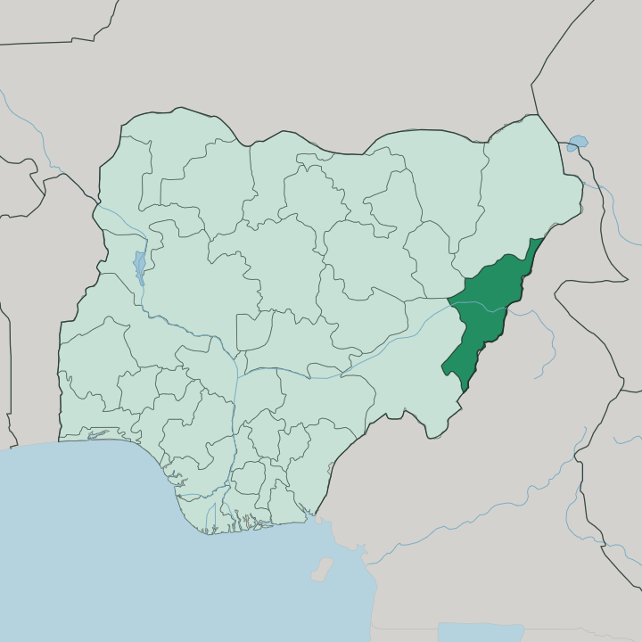
Towns & cities in Adamawa State
Pick a town or city — each links to where to stay.
Yola is the obvious base. The capital splits into Yola North, the administrative and commercial side around Jimeta on the Benue River, and Yola South, the older town that holds the Lamido's palace. Mubi, up near the Mandara Mountains, is the trading centre of the north and the nearest town of size to Sukur.
Choose Yola when you want the state's flights, offices, and river; choose Mubi if the mountain country and the Cameroon-border markets are what draw you east.
About Adamawa State
What is Adamawa State known for?
Adamawa carries the name of the old Adamawa Emirate, the Fulani state that Modibbo Adama founded and ruled from Yola. Its landscape is the second draw. The Mandara Mountains rise along the Cameroon border in the north, and it was on a ridge there, at Sukur, that Nigeria won its first UNESCO World Heritage listing for a terraced stone settlement still farmed by hand.
The Benue River cuts across the middle of the state, past Yola, the capital and traditional seat of the Lamido of Adamawa.
Where is Adamawa State?
Adamawa fills a corner of north-eastern Nigeria, its eastern edge tracing the international border with Cameroon. It is high country. Much of the state is plateau, savanna, and mountain rather than lowland, and three ranges give it its shape: the Mandara Mountains in the north, the Atlantika range along the border, and the Shebshi Mountains to the south, where the land reaches some of the highest ground in the whole country.
Water runs the other way. The Benue River enters from the east and drains the state westward, gathering the Gongola River and other tributaries as it goes, and Yola sits on its bank near the middle of the state. The interior around Yola is a broad plain, but the horizons are rarely flat.
Ridges and isolated hills break the savanna in every direction. To the north the ground climbs into the Mandara Mountains along the frontier, and it was on one of those ridges, at Sukur, that a terraced hilltop settlement earned Nigeria its first World Heritage listing. Borno lies to the north-west and Taraba to the south-west, but it is the mountains and the Benue that fix Adamawa in place, not the state lines.
What is Adamawa State like?
Few Nigerian states hold as many peoples as this one. Alongside the Fulani who founded the emirate, the hills and river valleys shelter Bwatiye, Chamba, Higgi, Margi, Kilba, and dozens more, so that Adamawa counts among the most ethnically varied states in the federation, with scores of distinct languages spoken in its towns and mountain villages. Fulfulde does the work of a common tongue.
It is the language of the old Fulani rulers, whose emir carries the title Lamido, and travellers hear it in the markets of Yola and Mubi alongside Hausa and English. The emirate still frames public life. The Lamido of Adamawa keeps his palace in Yola South, and the ceremonial durbar, a mounted procession of riders in robes, marks the great Islamic festivals there.
In the northern mountains the older cultures endure differently. At Sukur the dry-stone architecture, terraced fields, and iron-smelting tradition run back centuries, and the settlement is farmed and lived in still, not preserved behind glass. That mix, a Muslim emirate on the plain and ancient hill communities above it, is the texture of Adamawa.
What is the history of Adamawa State?
The name comes from a man. Modibbo Adama, a Fulani scholar, carried the flag of Usman dan Fodio's jihad into the region of Fombina in 1809 and built the emirate that took his name, moving its capital several times before fixing it at Yola in 1841. At its height the Adamawa Emirate was the largest in the Sokoto Caliphate, spilling far east over what is now northern Cameroon.
Colonial partition split it in 1901, leaving the Yola part in British Nigeria. Adamawa State itself is younger, cut from the former Gongola State in 1991.
What is the climate of Adamawa State?
Adamawa runs to a tropical savanna rhythm of one wet season and one long dry one. Rain falls from about April to October, heaviest in the middle months, greening the Benue valley and the slopes below the Mandara Mountains. Then the taps close.
From November the harmattan blows down out of the north-east, dry and dusty, hazing the horizons and dropping the nights cool before the heat builds toward the next rains. The higher ground in the south and along the Cameroon border stays milder than the plain around Yola.
How do you get to Adamawa State?
Most visitors fly into Yola. The airport sits at Jimeta on the northern side of the capital and takes domestic flights from Abuja and Lagos, a hop of not much over an hour from the federal capital. By road it is a long haul instead, the better part of a day's drive east from Abuja across the middle of the country.
Once in the state, roads fan out from Yola up the Benue valley to Numan and north toward Mubi and the Mandara Mountains near the Cameroon border.
Good for
Updated July 2026