Thailand
Changwat Chaiyaphum, Thailand — Towns & Travel Guide


Changwat Chaiyaphum, a province on the western edge of Isan, holds the source of the Chi River and Thailand's wild Siam tulip fields.
About Changwat Chaiyaphum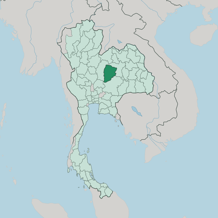


Towns & cities in Changwat Chaiyaphum
Pick a town or city — each links to where to stay.
Most trips base in Mueang Chaiyaphum, the provincial capital, where the hotels, night market, and the Chao Pho Phraya Lae shrine sit within a short ride of one another. The parks pull you outward. South toward Thep Sathit lie Pa Hin Ngam and Sai Thong, the Siam tulip country, best reached with your own wheels.
North, the road climbs to Tat Ton and the reservoir behind Chulabhorn Dam. Pick the town for comfort and connections; pick the park edges when the Krachiao is in bloom.
About Changwat Chaiyaphum
Two things put Changwat Chaiyaphum on the map.
What is Changwat Chaiyaphum known for?
Each rainy season, wild Siam tulips carpet the plateau at Pa Hin Ngam and Sai Thong national parks, a pink bloom that draws Thai visitors north from Bangkok. The province also guards the source of the Chi River and a string of waterfalls, chief among them Tat Ton. Ban Khwao weaves mudmee silk.
In the provincial town, the shrine of Chao Pho Phraya Lae honours the founder who defended the settlement against the armies of Vientiane.
Where is Changwat Chaiyaphum?
Changwat Chaiyaphum sits on the western rim of the Khorat Plateau, the great tableland that fills northeastern Thailand. The Phetchabun Mountains cut through it. West of that spine the land breaks into forested ridges and waterfalls, while the east settles into the dry, gently rolling farmland that defines the wider Isan.
The Chi River gathers in these western hills, near Phu Laen Kha, then curves east across the plateau to join the Mun River and, in the end, the Mekong. Rice, cassava, and sugar cane cover the lowlands between the ranges. Provinces ring it on every side. Khon Kaen lies to the north and Nakhon Ratchasima to the south, both plateau neighbours; Lopburi reaches up from the south-west and Phetchabun walls off the west.
Roughly a third of the province stays under forest. That green belt holds four national parks, Tat Ton, Sai Thong, Pa Hin Ngam, and Phu Laen Kha, along with the Phu Khiao Wildlife Sanctuary and the reservoir impounded behind Chulabhorn Dam in the far north. Elevation, not a coastline, sets the province apart.
The high ground is cool. Water and mountains, not the sea, shape how it is settled.
What is Changwat Chaiyaphum like?
Chaiyaphum reads as Isan with a central-Thai accent. Its founders were Lao, a group led by Nai Lae who crossed the Mekong and settled the plain, and the everyday language here is the Lao-rooted Isan tongue rather than the Bangkok standard. Sticky rice, grilled chicken, and fiery som tam anchor the table, as they do across the northeast.
The rhythm is rural and slow. Foreign faces stay rare, and the province keeps the unhurried feel of farm country that trades with the parks and the towns nearby. Craft carries the province's name furthest.
In the village of Ban Khwao, looms turn out mudmee silk, its patterns tie-dyed into the thread before weaving, and the cloth ranks among the finest in the country. Faith and memory shape the calendar too. Each cool season the town honours Chao Pho Phraya Lae, the founding chief later titled Phraya Phakdi Chumphon, with a fair that fills the streets for days.
Older still is Prang Ku, a laterite Khmer sanctuary on the town's edge, once a wayside chapel of the empire that ruled from Angkor. Devotion, silk, and the tulip fields give the year its shape.
What is the history of Changwat Chaiyaphum?
The town of Ban Luang, the seed of modern Chaiyaphum, was laid out in 1817 by Lao migrants under a leader named Lae. It answered to Nakhon Ratchasima and, through it, to the court at Bangkok. That bond was tested in 1826, when Chao Anouvong of Vientiane rose against Siam; Lae stayed loyal to Bangkok and died in the fighting, and the province venerates him still as Chao Pho Phraya Lae.
The Khmer came earlier. Their laterite sanctuary, Prang Ku, still stands at the town's edge, and the name Chaiyaphum keeps its old Sanskrit sense, the land of victory.
What is the climate of Changwat Chaiyaphum?
Chaiyaphum runs on three seasons, not four. The hot months from around March bake the plateau hard, and the heat sits heaviest on the open farmland east of the mountains. Then the southwest monsoon arrives.
Its rains green the Phetchabun highlands from May onward and set off the Siam tulip bloom in the parks. Cool, dry weather follows toward the year's end, when nights on the upland ridges turn genuinely cold. The Chi River runs high in the wet, low in the dry.
How do you get to Changwat Chaiyaphum?
Roads do the work here. Chaiyaphum lies roughly 340 kilometres northeast of Bangkok, reached by the Mittraphap highway and then the spur that climbs to the provincial town; long-distance coaches run the same route from the capital's Mo Chit terminal. The province has no airport of its own.
The nearest runways sit at Nakhon Ratchasima and Khon Kaen, each within a couple of hours by road. No railway crosses it either, the closest stations lying at Bua Yai to the south and Khon Kaen to the north. For the parks, a hired car earns its keep.
Good for
Updated July 2026