Thailand
Changwat Kalasin, Thailand — Towns & Travel Guide


Kalasin is a province of upper Isan in northeastern Thailand, dinosaur country of fossil beds at Phu Kum Khao and Phu Thai silk villages.
About Changwat Kalasin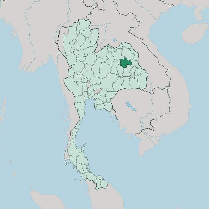


Towns & cities in Changwat Kalasin
Pick a town or city — each links to where to stay.
Mueang Kalasin is the natural base, the only town with a full spread of hotels, gathered beside the Pao River and the lake park of Kaeng Don Klang. The sights lie outward. North of the capital, Sahatsakhan holds the Phu Kum Khao dinosaur dig and the Sirindhorn Museum built above it.
East, the hills rise. Kham Muang and Kuchinarai are Phu Thai country, where looms at Ban Phon weave Phrae Wa silk and the road climbs toward Phu Phan National Park. Choose the town for comfort; choose the eastern districts for silk and forest.
About Changwat Kalasin
What is Changwat Kalasin known for?
Kalasin sells itself as the land of dinosaurs, and the claim is earned. At Phu Kum Khao in Sahatsakhan the ground gave up Thailand's most complete bonebed of sauropods, and the Sirindhorn Museum was built over the dig to show the skeletons where they lay. The other signature is cloth.
Phu Thai women in Ban Phon weave Phrae Wa silk, the tight brocade that palace patronage made the queen of Thai fabrics. Between the two spreads the Lam Pao reservoir, the great sheet of irrigation water that anchors the northern districts.
Where is Changwat Kalasin?
Kalasin lies in upper Isan, on the northern reach of the Khorat Plateau in northeastern Thailand, roughly 520 kilometres from Bangkok. A ring of six provinces borders Kalasin. Udon Thani and Sakon Nakhon border it to the north, with the wooded Phu Phan range walling off Sakon Nakhon along the northern rim, where the ridgeline is kept as Phu Phan National Park. Mukdahan lies to the east and Roi Et to the south.
Maha Sarakham closes the south-western corner, and Khon Kaen the west. Most of the land is farm country. Sticky rice, cassava, and sugar cane cover a gently rolling plain a few hundred metres above the sea, tilting south toward the rivers.
Water gives the province its shape. The Lam Pao gathers in the Phu Phan hills and runs south through the heart of Kalasin, where a dam completed in 1968 holds it back as the broad Lam Pao reservoir, a sheet of irrigation water that all but splits the north in two. Below it the stream drains on to the Chi River, the long river that traces the province's southern edge before carrying its water east toward the Mun and the Mekong.
The plateau has no coast and no great height. Elevation and river, not the sea, decide how Kalasin is settled and farmed.
What is Changwat Kalasin like?
Kalasin is Isan through and through, Lao-speaking and rice-farming, but it carries a second identity that sets it apart. Much of the eastern province is Phu Thai, a Tai people who crossed the Mekong generations ago and kept their own dialect, dress, and rites. Their craft is the province's pride.
In the village of Ban Phon the Phu Thai weave Phrae Wa silk, a dense supplementary-weft brocade in red, green, and violet that royal patronage lifted to the front rank of Thai textiles. The everyday tongue is the Lao-rooted Isan dialect, not the Bangkok standard, and the table is pure northeast: sticky rice eaten by hand, grilled chicken, and som tam pounded fierce with chilli and fermented fish. Its other face is prehistoric.
The province has made the dinosaur its emblem, since the bonebeds at Phu Kum Khao gave up some of the finest sauropod skeletons in the region, and cartoon dinosaurs stand at its roundabouts and gates. Deep memory runs older still. At Mueang Fa Daet, a moated Dvaravati town in Kamalasai, carved boundary stones and an Old Mon inscription record a Buddhist settlement of the eighth century, long before any Lao or Phu Thai arrived.
The calendar keeps all of it alive. Cool-season fairs honour the Phrae Wa weavers and the Phu Thai dances, and merit-making at the wats marks the turning of the farming year.
What is the history of Changwat Kalasin?
The town began in 1793. A Lao-Phu Thai leader, Thao Somphamit, led his followers across the Mekong and settled a bend of the Pao River at a spot called Ban Kaeng Samrong. King Rama I raised the settlement to a walled town, renamed it Kalasin, the black water, and appointed its founder as Phraya Chaisunthon, its first governor.
The mueang answered to Bangkok thereafter. Kalasin lost its rank in 1932, folded into Maha Sarakham through the lean depression years, and won back its standing as a province in 1947.
What is the climate of Changwat Kalasin?
Kalasin runs on three seasons, not four. The hot months from March scorch the open plateau, and the rice paddies crack dry before the rains. Then the southwest monsoon breaks over the Phu Phan hills.
Rain falls from May into October, filling the Lam Pao reservoir and the Chi so the fields can be planted. The cool, dry season from November brings the traveller's window, clear days and nights that turn genuinely cold on the higher ground. Heat, not frost, is the province's hard season.
How do you get to Changwat Kalasin?
Kalasin has no airport. Most visitors fly into Khon Kaen, the nearest runway, an hour or so west by road, with Roi Et and Udon Thani as fallbacks on the other sides. No railway crosses the province either, so drivers come up from Bangkok, roughly 520 kilometres south-west, on the Mittraphap highway and the plateau roads that branch off it.
Long-distance coaches run the same haul from the capital's Mo Chit terminal. Inside the province a car pays for itself, not least on the Thesuda Bridge, the long causeway that vaults the Lam Pao reservoir.
Updated July 2026