Thailand
Changwat Satun, Thailand — Towns & Travel Guide


Satun is a Muslim-majority province on Thailand's Andaman Sea coast, holding the Tarutao islands and the country's first UNESCO fossil geopark.
About Changwat Satun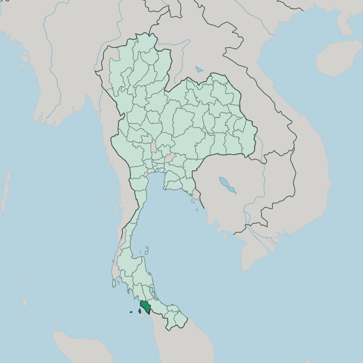


Towns & cities in Changwat Satun
Pick a town or city — each links to where to stay.
Most visitors split their nights between island and mainland. Ko Lipe is the resort base, a small island fringed with coral and reached only by boat. The town of Satun handles the everyday business of the province, close to the Tammalang Pier ferry over to Langkawi.
Boats for the national parks leave from Pak Bara, up the coast in La-ngu district. It divides by water. Choose Ko Lipe for reef diving and quiet sand; choose the mainland for its mosques, its night markets and an easy ferry hop across the Malaysian border to Langkawi.
About Changwat Satun
Two things put Satun on the map: its islands and its rocks.
What is Changwat Satun known for?
Boats leave the mainland for Tarutao National Park, a scatter of 51 islands where old prison ruins share the shore with monitor lizards and empty sand. Ko Lipe anchors the tourist side, ringed by coral in the far south of the Andaman Sea. Inland, the province forms Thailand's first UNESCO Global Geopark, ground built from 500-million-year-old Palaeozoic rock and some of the oldest trilobite fossils on the Malay Peninsula.
The mood is unhurried. Muslim fishing towns and rubber country fill the space between the piers and the peaks.
Where is Changwat Satun?
Satun sits at the south-western corner of Thailand, on the Malay Peninsula, where the land runs down to the Andaman Sea. Its whole western edge is coast and island. The province faces open water to the west, and its southern boundary is an international one: beyond the ridges lies Perlis, the smallest state of Malaysia.
Three Thai provinces close off the rest. Trang lies to the north, Phatthalung to the north-east across the hills, and Songkhla to the east over the Nakhon Si Thammarat mountain range. That range divides Satun from the Gulf coast, and a second chain, the Nakawan Range, carries the frontier with Malaysia.
Forest still covers close to half the province, climbing from mangrove and rubber into steep limestone. Offshore, the map breaks into pieces. Nearly a hundred islands belong to Satun, most of them empty.
The largest is Ko Tarutao, a long jungled island near the mainland; further out sit Ko Adang, Ko Rawi and the small tourist island of Ko Lipe. The provincial town of Satun stands a little inland on a tidal river, roughly 973 km south of Bangkok and close enough to the border that the call to prayer carries across the paddies. It is a corner of the country that looks more toward the sea than toward the capital.
What is Changwat Satun like?
Satun feels closer to the Malay world than to central Thailand. Most of the province is Muslim, and most of those families are of Malay descent, though the everyday language on the street has shifted to Southern Thai rather than Malay. Mosques mark the villages instead of temple spires.
The food follows suit, leaning on the curries, roti and grilled fish of the peninsula rather than the sweet-sour flavours of the north. Buddhist and Muslim neighbours have long shared this coast without the tension that has troubled the provinces to the east. That is the local point of pride.
Two older peoples still hold their ground here. The Urak Lawoi, sea nomads of the Andaman, keep a village on Ko Lipe and have fished these reefs for generations. In the forested hills toward the Malaysian border live small bands of Maniq, one of the last hunter-gatherer groups on the Malay Peninsula.
Rubber tapping, coastal fishing and island tourism set the working rhythm of the province. The old Kuden Mansion in Satun town, a Sino-Malay building of arched windows and shuttered verandas, now holds the provincial museum and tells that layered story. Faith, sea and forest run through all of it.
What is the history of Changwat Satun?
Satun began as a Malay outpost of Kedah, the sultanate that once ran both shores of this stretch of the peninsula. Its name is a Thai rendering of Setul, the Malay word for a local fruit tree. For a time it governed itself as the small state of Setul Mambang Segara.
Treaty, not war, drew the line. Under the Anglo-Siamese Treaty of 1909, Britain kept Kedah and Perlis while Siam retained Satun, where Thai-speakers outnumbered Malay. It has answered to Bangkok ever since.
What is the climate of Changwat Satun?
The heat here barely moves; only the rain does. Satun runs hot and humid all year, with the seasons set by the monsoon rather than by temperature. The south-west monsoon drives in off the Andaman Sea from about May to October, and the wet months can close the outer islands when the swell picks up.
Drier, calmer weather returns from November through April, which is when the boats to Tarutao and Ko Lipe run most reliably. Rain, not frost, marks the calendar.
How do you get to Changwat Satun?
Satun has no airport of its own. Most travellers fly into Hat Yai, over in Songkhla, then ride a couple of hours west by minivan to the coast. Ferries do much of the rest.
From Tammalang Pier, boats cross the strait to Langkawi in Malaysia, and in the dry season fast boats run straight out to Ko Lipe. For Tarutao and the other national-park islands, the jumping-off point is the pier at Pak Bara. Overland, a quiet border post links the province to Perlis through the hills.
Good for
Updated July 2026