Thailand
Changwat Sukhothai, Thailand — Towns & Travel Guide


The province in Thailand's lower north where the Sukhothai Kingdom rose in the 13th century, its first capital now a ruined park by the Yom River.
About Changwat Sukhothai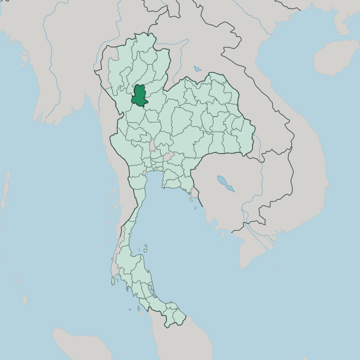


Towns & cities in Changwat Sukhothai
Pick a town or city — each links to where to stay.
Two Sukhothais split the choice. New Sukhothai, the working town on the Yom River, holds most of the guesthouses, night-market food, and the buses and flights out, and it makes the easy day-trip base for the ruins twelve kilometres west. Old Sukhothai, the walled Mueang Kao beside the Historical Park, lets you cycle through the chedis at opening before the coaches arrive.
For the quieter kilns and forest temples, base further north at Si Satchanalai. Pick the town for convenience, the old city for the dawn light.
About Changwat Sukhothai
What is Changwat Sukhothai known for?
The province is known for one thing above all: the birthplace of the Thai state. Its old capital survives as Sukhothai Historical Park, a moated field of brick chedis, seated Buddhas, and lotus-bud spires left by the 13th-century kingdom. Ceramics carried its name abroad.
The kilns of Si Satchanalai and Sawankhalok fired the celadon and painted stoneware that Thai traders shipped across maritime Southeast Asia. Loi Krathong, the festival of floating lights, is held to have taken shape here on the old city's ponds.
Where is Changwat Sukhothai?
Changwat Sukhothai lies in the lower north of Thailand, inland and landlocked, well up the central plain from Bangkok. The Yom River is its spine. That river enters from Phrae in the north and runs the length of the province before continuing south toward its meeting with the Nan River, and the flat paddy country along its banks holds most of the towns and farms.
West of the valley the land climbs. The Khao Luang range rises in Ramkhamhaeng National Park, wooded ridges that mark the province's higher, emptier flank. Six provinces hem Sukhothai in, Phrae to the north and Tak and Lampang shutting the western hills.
Phrae stands to the north, Uttaradit and Phitsanulok along the eastern side, Kamphaeng Phet to the south, and Tak and Lampang closing the western hills. The old royal cities were placed with this geography in mind. Sukhothai itself stands on the plain near the Yom, while Si Satchanalai guards the river valley upstream where it narrows between the hills.
Between the western mountains and the river lies the belt of level ground that fed the kingdom. It is a province of two halves, the worked floodplain and the forest ridge above it.
What is Changwat Sukhothai like?
Thais treat this province as the source of their culture. The Sukhothai Kingdom set the templates. Its sculptors gave Thai art the walking Buddha, a striding bronze figure with flowing robes found almost nowhere else, and the lotus-bud stupa that crowns the ruins to this day.
King Ram Khamhaeng is credited with the first Thai alphabet, cut into a stone stele that later kings and scholars read as the founding text of the written language. That script is the ancestor of the letters Thailand still uses. Religion was set here too, with Theravada Buddhism taking hold as the faith of the court and the country.
Craft ran alongside art. The potters of Si Satchanalai turned out the green-glazed celadon and painted wares, the Sangkhalok ceramics, that reached ports across the region. Even the calendar turns on Sukhothai.
Loi Krathong, when small rafts of banana leaf and candlelight are set adrift, is traced by tradition to a lady of this court, and the province stages it among the floodlit ruins each year. The Thai language, Theravada temples, and the festival of lights all point back to the same plain. What began at Sukhothai spread to become the shared culture of the nation.
What is the history of Changwat Sukhothai?
The kingdom began in 1238. Tai chiefs led by Si Inthrathit threw off Khmer overlordship and founded a capital on the Yom plain, the first enduring Thai state. Under Ram Khamhaeng, who reigned from 1279 to 1298, its reach stretched far down the peninsula and its court gave Thailand its alphabet.
The golden age was brief. Power drained east to the rising Ayutthaya Kingdom, which absorbed Sukhothai in 1438, and the old cities were left to the forest. Centuries later the ruins were cleared and made a province again.
What is the climate of Changwat Sukhothai?
Sukhothai runs hot. The province has a tropical wet-and-dry climate with three clear seasons, and the calendar is ruled by the monsoon rather than by temperature. From roughly February the heat builds, peaking in a fierce, dusty April before the rains break.
The wet monsoon then runs from about May into October, when the Yom River swells and the paddy country turns green. Cooler, drier air settles from November to January, the kindest stretch for walking the ruins. That short cool season is when most travellers come.
How do you get to Changwat Sukhothai?
Most travellers reach Sukhothai by air. Bangkok Airways runs the quickest link, a short hop from Bangkok to the airport that the airline built and owns north of the town, a garden strip more like a resort than a terminal. The overland alternative goes through Phitsanulok, the nearest big rail and air hub, from which minivans and buses cover the last stretch west to Sukhothai in about an hour.
Direct coaches also grind up from Bangkok's northern terminal in seven to eight hours. Whichever way you arrive, New Sukhothai is the base, and songthaews shuttle the twelve kilometres out to the ruins.
Updated July 2026