Thailand
Changwat Uttaradit, Thailand — Towns & Travel Guide


Uttaradit is a province of Thailand's lower north, strung along the Nan River from the central plain east to the Laos border.
About Changwat Uttaradit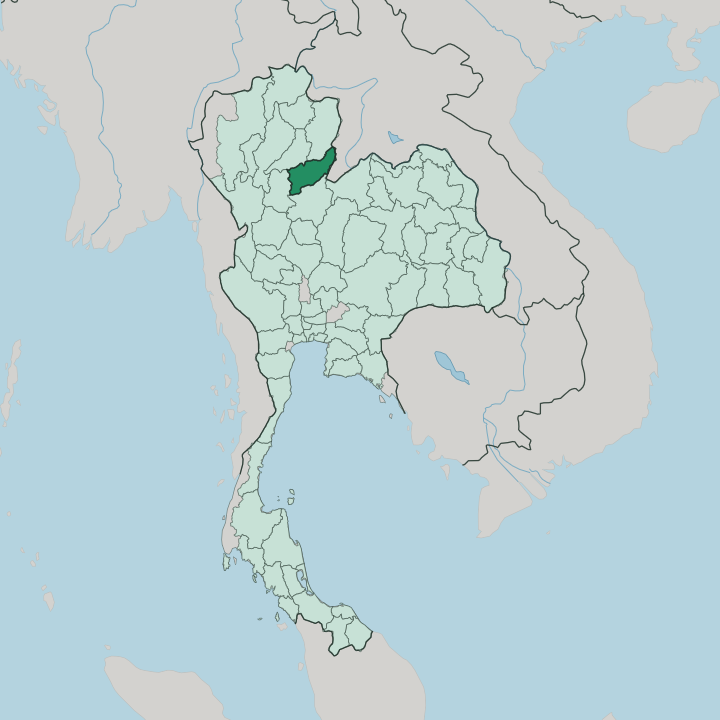


Towns & cities in Changwat Uttaradit
Pick a town or city — each links to where to stay.
The city of Uttaradit is the obvious base. It sits on the Nan River beside the Northern Line railway, holding the province's hotels, markets, and the through trains north and south. Laplae lies a short ride west, an orchard town of durian and langsat with its old gate and folk museum.
For water and forest, go inland. Tha Pla opens onto the Sirikit Dam lake, while Nam Pat is the roadhead for the Phu Soi Dao waterfall on the Laos border. Pick the city for trains and food; pick the hills for the reservoir and the trek.
About Changwat Uttaradit
Uttaradit answers to a broken sword.
What is Changwat Uttaradit known for?
The province raised Phraya Phichai, the general who fought on for King Taksin after his blade snapped defending the town against a Burmese column, and his two-sworded statue still stands before the provincial hall. Beyond that memory it is orchard and reservoir country. Laplae district grows the odorless Long Laplae and Lin Laplae durians and baskets of langsat, while the Nan River backs up behind the Sirikit Dam into a lake that reaches deep into the hills.
Where is Changwat Uttaradit?
Uttaradit sits inland in the lower north of Thailand, landlocked and well up the plain from Bangkok. The Nan River is its axis. That river comes down from Nan in the north and threads the province from top to bottom before running on toward Phitsanulok and the wider central plain, and the flat paddy land along its banks carries most of the towns and orchards.
The province leans east against Laos. There the Sainyabuli hills mark the frontier, and the land climbs steeply away from the valley floor. Phrae and Nan close the north, Sukhothai and Phitsanulok the south, so only the eastern edge looks abroad.
High ground frames both flanks. The Phi Pan Nam Range breaks up the northwest, while the eastern border rises into the higher country of Phu Soi Dao, where a five-tier waterfall drops through the forest and the ridge tops out over two thousand metres near the Laos frontier. Between them the Nan River is dammed.
The Sirikit Dam holds it back into a long reservoir that fingers deep among the hills of Tha Pla, drowning the old river valleys. Forest still covers more than half the land. In the Ton Sak Yai park stands a teak claimed as the largest in the world, and the orchard slopes of Laplae climb west toward the same wooded ridges.
It is a province of one river and the mountains that feed it.
What is Changwat Uttaradit like?
The province wears its hero on its sleeve. Phraya Phichai, the broken-sword general, is the face of Uttaradit, honoured each year on the seventh of January with rites at his statue before the provincial hall. His loyalty to King Taksin is the story children learn first here.
But the deeper identity is agricultural, and it ripens in fruit. Laplae is famous across Thailand for its durian, and the district holds a durian festival as the first harvest comes in, matched by a langsat and longkong festival at the end of the growing year. Both draw buyers from far beyond the province.
Older layers run under the orchards. Uttaradit means the port of the north, and the province grew as a landing on the Nan River where goods moved between Laos and the Thai heartland. Teak was the trade that built it, and teak is still the provincial tree.
Faith left its own marks. The mondop of Wat Phra Thaen Sila At in Laplae, a shrine raised over an ancient stone slab, is old enough to sit at the centre of the provincial seal. Laplae guards a legend too, of a hidden town of women where no one was permitted to lie, its name meaning concealed from sight.
Thai is the common tongue, in a northern accent. The talk here still carries the lilt of the upland north.
What is the history of Changwat Uttaradit?
The land belonged to Sukhothai first. Small river towns here answered to the 13th-century Sukhothai Kingdom before Ayutthaya rose to the south. Its sharpest moment came in 1773, when the lord of Phichai broke a Burmese assault, fought on after his sword shattered, and earned the name that the province still salutes.
The modern province is younger. The river port of Bang Pho Tha It, once a landing under Phichai on the Nan, was raised to a mueang in 1887 and later took the crown-granted name Uttaradit, the port of the north.
What is the climate of Changwat Uttaradit?
Uttaradit runs hot and dry by turns. The province has a tropical wet-and-dry climate, and the monsoon rules the calendar more than the thermometer does. Heat builds through a fierce, dusty April, the hardest month, before the rains break.
From May into October the southwest monsoon soaks the hills and swells the Nan River, greening the durian and langsat orchards of Laplae. Then the air turns cool and dry from November. That short cool spell is the kindest time to travel.
How do you get to Changwat Uttaradit?
The train is the natural way in. Uttaradit sits on the Northern Line about midway between Bangkok and Chiang Mai, and the sleepers and day expresses all call at its station. The province has no working airport of its own.
Fliers land instead at Sukhothai or Phitsanulok to the south, or at Phrae to the north, then finish by road. Buses grind up the north-south highway through the Nan valley as well. From the city, songthaews and hired trucks fan out to Laplae, the Sirikit Dam, and the trailheads near Phu Soi Dao.
Good for
Updated July 2026