Thailand
Changwat Tak, Thailand — Towns & Travel Guide


Tak is a mountainous province on Thailand's western border with Myanmar, its forests split by the Ping River and the great Bhumibol Dam.
About Changwat Tak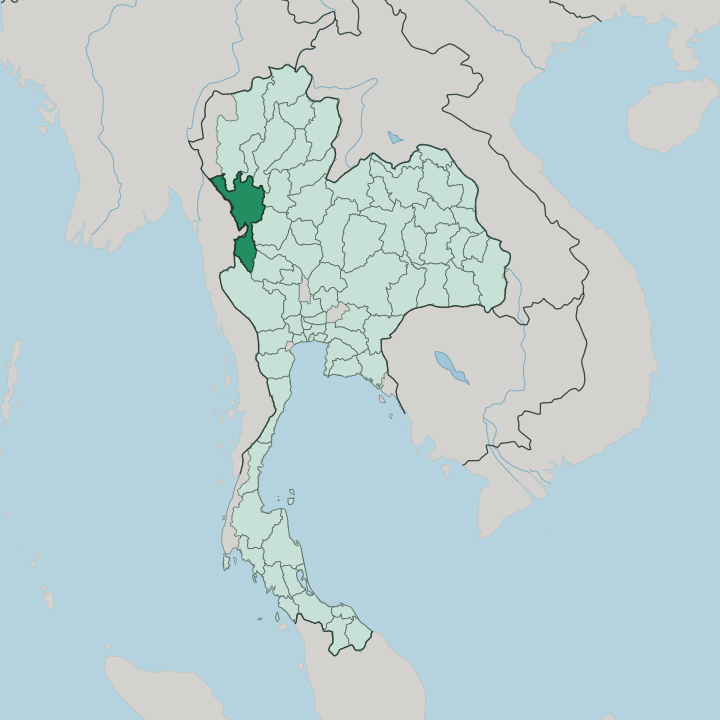


Towns & cities in Changwat Tak
Pick a town or city — each links to where to stay.
Mae Sot is the natural base. This is the border town where most trips begin, an ethnically Burmese market on the Thai bank of the Moei River, and the launch point for the roads west. For waterfalls and jungle rafting, base yourself in Umphang, a hard day's drive south on a switchback mountain road.
Tak city, the quiet provincial capital, sits on the Ping River between the two. Guesthouses also gather near the Bhumibol Dam in the north. Pick Mae Sot for the crossing and its markets; choose Umphang when the forest is the whole point.
About Changwat Tak
Forest and frontier define Tak.
What is Changwat Tak known for?
Thi Lo Su, the largest waterfall in Thailand, tumbles in tiers through the Umphang Wildlife Sanctuary, deep in the roadless south where rafting trips run when the rains close the road. The Bhumibol Dam holds back the Ping River in the north. Mae Sot, the trading town on the Moei River, handles most of the overland traffic crossing between the two countries.
King Taksin took his name from the town he governed, ruling here before he founded the kingdom of Thonburi.
Where is Changwat Tak?
Tak stretches along Thailand's western border with Myanmar, a long and mountainous province in the country's west. The Dawna Range and the Tenasserim Hills fold together down its western edge, and the Moei River marks much of the boundary with Kayin State on the Burmese side. Inside Thailand it touches nine other provinces. Chiang Mai and Lamphun lie to the north, Sukhothai and Kamphaeng Phet across the flatter eastern side, and Kanchanaburi far to the south.
Bangkok sits well to the south-east, several hours away by road. The Ping River is the spine of the province. It flows down out of the northern hills toward the plains, feeding the Chao Phraya far downstream, and the Bhumibol Dam pools it into a long reservoir behind Thailand's highest dam wall.
Forest covers most of the land. Roughly three-quarters of Tak is wooded, thickest in the southern wilds around the Umphang Wildlife Sanctuary, where the Thi Lo Su waterfall spills off a limestone escarpment. Those southern sanctuaries join the vast Western Forest Complex that runs down toward Kanchanaburi.
Away from the Ping valley and the two main roads, much of the province is steep, remote, and thinly settled.
What is Changwat Tak like?
Tak feels like a border province, because it is one. Along the Moei River, Thai gives way to Burmese and to the Karen tongue of the hills, and Mae Sot's markets trade in jade, teak, and goods carried over from Myanmar. Roughly a quarter of the province belongs to the hill peoples, Karen above all, with Hmong, Lahu, and Lisu communities scattered through the ranges.
Decades of conflict across the border have left large Karen refugee settlements in the western districts, Mae La the biggest among them. The result is a cultural mix unlike the Thai heartland to the east. The lowland Thai side keeps its own traditions.
Tak is famous for Loi Krathong Sai, a version of the lantern festival in which thousands of small coconut-shell lamps are strung into long chains and floated down the Ping River after dark. The province guards the memory of King Taksin, who governed the old town before he drove out the Burmese and founded a new kingdom at Thonburi. Shrines to him stand in Tak city.
Life here runs slower than in the tourist north, closer to the forest and the river than to any city.
What is the history of Changwat Tak?
Tak is old. A settlement stood at Ban Tak long before Sukhothai, on a caravan route between the Chao Phraya plains and the Burmese lands beyond the hills. Under the Sukhothai Kingdom and then Ayutthaya, the town guarded the western passes against repeated Burmese invasions.
Its most famous son took his name from it: Sin, governor of Tak, became King Taksin when he expelled the Burmese and refounded the Siamese state at Thonburi after the fall of Ayutthaya. The provincial seal still shows King Naresuan on his war elephant, a memory of those border wars.
What is the climate of Changwat Tak?
Tak runs on three seasons. The cool, dry months from November to February are the time to come, when the air over the hills turns crisp and the Umphang forests are open to trekkers. Hot season follows, building through March and April until the first storms break.
Then the southwest monsoon soaks the province from May into October, swelling the Thi Lo Su waterfall and washing out the mountain road to Umphang, so the far south can be reached only by raft and on foot. The uplands always stay cooler than the Ping valley floor.
How do you get to Changwat Tak?
Most people reach Tak by road from Bangkok, a drive of several hours north through Nakhon Sawan. Buses run from the capital's northern terminal to Tak city and on to Mae Sot. The quickest way is to fly.
A small airport at Mae Sot takes flights from Bangkok, cutting out the long haul overland. From Mae Sot the Asian Highway crosses the Moei River on the Thai-Myanmar Friendship Bridge into Myawaddy, the main land route between Thailand and Myanmar, while a steep, twisting road climbs south to Umphang.
Good for
Updated July 2026