Thailand
Changwat Uthai Thani, Thailand — Towns & Travel Guide


Uthai Thani is a quiet river province in Thailand's lower north, where the Sakae Krang threads a small riverside town below forested western hills.
About Changwat Uthai Thani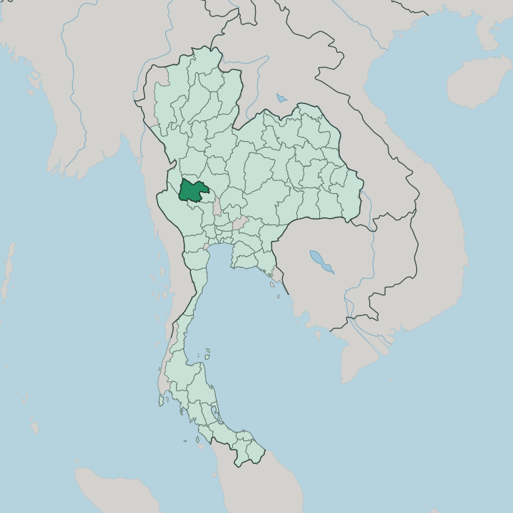


Towns & cities in Changwat Uthai Thani
Pick a town or city — each links to where to stay.
Most visitors base themselves in the provincial town, a compact grid of shophouses along the Sakae Krang. Past the provincial town, rooms grow sparse quickly. West of the plains, a scattering of resorts and homestays edges the forest districts of Lan Sak and Ban Rai, handy for Huai Kha Khaeng and the sinkhole valley of Hup Pa Tat.
Pick the riverside town for markets and temples; choose the hills when the forest is the point. Nothing here lies far apart.
About Changwat Uthai Thani
Two things define this province.
What is Changwat Uthai Thani known for?
The Sakae Krang River runs through the provincial town, lined with wooden houses and floating rafts where families raise giant gourami in submerged baskets. West of the plains, the Huai Kha Khaeng Wildlife Sanctuary protects tigers, wild elephants and one of mainland Southeast Asia's largest tracts of undisturbed forest, inscribed by UNESCO in 1991. Above the town rises Khao Sakae Krang, a limestone hill crowned by Wat Sangkat Rattana Khiri, reached by a staircase of 449 steps.
The whole place moves at the river's pace.
Where is Changwat Uthai Thani?
Uthai Thani sits in Thailand's lower north, on the western rim of the great Chao Phraya plains. Uthai Thani leans from east to west. Its eastern districts are flat, wet rice country, part of the broad valley the Chao Phraya has flooded and farmed for centuries, while the west climbs into forested limestone hills that shoulder up against the border ranges with Myanmar.
Nearly half the province is still forest. The Sakae Krang River drains that upland, running for some 225 kilometres before it slips into the Chao Phraya close to the provincial town, past the mirrored halls of Wat Tha Sung. Most of that river's length lies inside Uthai Thani.
Neighbours ring it on five sides. Nakhon Sawan lies to the north and east, Chai Nat to the east, Suphan Buri to the south, and Kanchanaburi and Tak close off the wild western flank. It is the Tak border, deep in the hills, that carries the Huai Kha Khaeng forest. Bangkok is about 200 kilometres away, yet the province sits off the main road north to Chiang Mai, which is part of why it stays quiet.
Few travellers pass through by accident.
What is Changwat Uthai Thani like?
Life here bends toward the river and the temple. Theravada Buddhism sets the rhythm, and the province's grandest moment comes the morning after Ok Phansa, the close of Buddhist Lent. Then, at Wat Sangkat Rattana Khiri, hundreds of saffron-robed monks file down the 449 steps of Khao Sakae Krang to receive alms from crowds waiting below, a re-enactment of the Buddha's descent from the heavens that gives the Tak Bat Devo festival its name.
Across the town, Wat Tha Sung answers with a very different spectacle: a hall sheathed entirely in mirrored glass. Faith is worn plainly. It shapes the calendar more than any market does.
Away from the shrines, the Sakae Krang River itself is a workplace. Families tether floating bamboo rafts to the banks and raise giant gourami in cages slung beneath their houses, and along the shallows they cultivate pandanus, whose fragrant leaves flavour and colour Thai sweets. In the western hills, Karen communities farm and keep older ways around Ban Rai.
The province also guards a royal thread: it remembers itself as the home district of the father of Rama I, founder of the Chakri line, and a hilltop pavilion honours him. Pomelo orchards ripen on the plains. None of it hurries.
What is the history of Changwat Uthai Thani?
Uthai Thani's story begins before the Thai. Mon and Lawa peoples worked this land first, and a Sukhothai-era town called Muang U Thai stood nearby until shifting river courses drained it and forced a move. The settlement that replaced it grew into the modern town.
Its proudest claim is dynastic: this was the home district of Thongdee, father of Rama I, whose line still reigns. King Chulalongkorn folded the area into Monthon Nakhon Sawan in 1892, and Uthai Thani took its place as a province of its own in 1898.
What is the climate of Changwat Uthai Thani?
Uthai Thani runs to three seasons, not four. The heat builds through March and April until the southwest monsoon breaks in around May, feeding the rains that swell the Sakae Krang and green the western forests until October. Then the skies clear.
A cool, dry spell settles from November into February, the easiest months to climb Khao Sakae Krang or walk the Huai Kha Khaeng trails. The forested hills of the west catch noticeably more rain than the dry plains along the Chao Phraya to the east.
How do you get to Changwat Uthai Thani?
Uthai Thani has neither an airport nor a railway of its own. Most people arrive by road from Bangkok, roughly 200 kilometres to the south, a bus ride of about four hours from the Northern Terminal at Mo Chit. Trains stop short.
The nearest railhead sits across the river in Nakhon Sawan, from where a short hop by road finishes the trip. Once in the provincial town, songthaews and tuk-tuks cover the rest. Come by land or not at all.
Updated July 2026