Vietnam
Dak Lak, Vietnam — Towns & Travel Guide


Đắk Lắk is Vietnam's coffee heartland, a basalt plateau in the Central Highlands where the Srepok River drains west into the Mekong.
About Dak Lak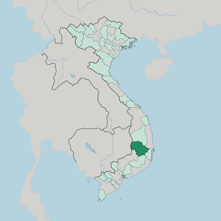


Towns & cities in Dak Lak
Pick a town or city — each links to where to stay.
Most travellers base themselves in Buôn Ma Thuột, the largest city and the only one of any real size on the plateau. Coffee runs the social calendar. For water and quiet, Lắk Lake sits an hour south, ringed by M'Nông villages and stilted longhouses where boats and elephants once did the work of roads.
West toward the Cambodian border, Buôn Đôn keeps its elephant-catching settlements beside Yok Don National Park. Stay in Buôn Ma Thuột if you want cafés and connections; take the lake or the forest for the villages.
About Dak Lak
Coffee defines Đắk Lắk.
What is Dak Lak known for?
The red basalt soil around Buôn Ma Thuột grows more robusta than anywhere else in Vietnam, and the beans carry the province's name to roasters across the world. Beyond the plantations lies older ground. The Central Highlands gong music practised by the Ê Đê and other peoples here is listed by UNESCO as a Masterpiece of the Oral and Intangible Heritage of Humanity, played on tuned bronze at weddings, funerals, and harvest rites.
Wild elephants still roam the dry forests of Yok Don National Park.
Where is Dak Lak?
Đắk Lắk spreads across a broad basalt plateau in the Central Highlands, the tableland that climbs inland from the coast near Nha Trang. The land here is red earth and rolling upland, weathered from old volcanic rock, and it climbs to around half a kilometre above the lowlands. That height is what makes the coffee, and the weather.
Two rivers born on the plateau, the Krông Ana and the Krông Nô, join below Buôn Ma Thuột to form the Srepok River. Unlike almost every other river in the country, the Srepok runs the wrong way. It flows west and away from the sea, crossing into Cambodia to feed the Mekong rather than the coast.
Along that westward course it drops over a string of three waterfalls, of which Dray Nur is the widest. The plateau also holds still water. Lắk Lake, the largest natural lake on the plateau and the second-largest in Vietnam, lies south of Buôn Ma Thuột among the M'Nông hamlets.
To the north and west the plateau gives way to Yok Don National Park, the country's largest protected area, a rare stretch of open dry-forest where wild elephants still range toward the Cambodian frontier. Lâm Đồng adjoins Đắk Lắk on the south, Gia Lai on the north, and Cambodia's Mondulkiri shares the western edge. It stays high and red, tilted west to the Mekong, yet the province runs east to the sea.
What is Dak Lak like?
Two worlds share the plateau. The lowland Kinh built the coffee estates and the towns, while the older highland peoples, the Ê Đê and the M'Nông chief among them, hold the villages and much of the land's memory. Ê Đê society runs through the mother's line. Families live in long wooden houses raised on stilts, extended a bay at a time as daughters marry, and a household's wealth is counted in gongs and jars.
The bronze gongs are not decoration. Tuned sets are played in overlapping rhythms to mark a birth, a burial, or the close of harvest, and the music is meant to be heard by the spirits as much as by the guests. Rice wine drunk through long reeds from a shared jar seals the same occasions.
The elephant runs through all of it. At Buôn Đôn, M'Nông and Lao mahouts once tracked and tamed wild herds, and a captured tusker made a family rich. That trade is gone, and the working elephants are old, but the animal still stands at the centre of local legend and festival.
Coffee, though, is the everyday ritual. Strong robusta, dripped slow through a metal filter over ice and condensed milk, is how mornings begin in Buôn Ma Thuột and how deals are done.
What is the history of Dak Lak?
For most of its past, the plateau answered to no lowland court. Highland peoples governed their own villages, and the elephant-trading settlement of Buôn Đôn was the seat that mattered. France changed that.
Colonial officials made Buôn Ma Thuột the capital of a new Đắk Lắk province in 1904 and planted the first coffee estates on the basalt. War left its deepest mark in 1975: the assault on Buôn Ma Thuột opened the Central Highlands campaign that broke the southern front and ended the war weeks later.
What is the climate of Dak Lak?
Đắk Lắk keeps two seasons, not four. The wet monsoon runs roughly from May to October, when afternoon downpours swell the Srepok River and send the waterfalls into full spate. Dry months follow.
From November the rain shuts off, the red roads turn to dust, and the coffee harvest comes in under clear skies. Height tempers the heat that bakes the coast: nights on the plateau run cool, and Buôn Ma Thuột rarely swelters the way the lowlands do.
How do you get to Dak Lak?
No railway climbs onto the plateau. Buôn Ma Thuột Airport handles the traffic, with domestic flights linking the city to Hồ Chí Minh City and Hà Nội. Drivers climb instead.
The main road bends up from the coast near Nha Trang, trading sea-level heat for red-dirt uplands over a few hours of switchbacks, and long-distance buses run the same route through the night. East of the highlands the province reaches the sea, where the North-South railway and Tuy Hòa Airport give a coastal way in. From Buôn Ma Thuột, smaller roads fan out to Lắk Lake, Buôn Đôn, and the border.
Good for
Updated July 2026