Vietnam
Tỉnh Thanh Hóa, Vietnam — Towns & Travel Guide


Thanh Hóa is the northernmost province of Vietnam's north-central coast, where the Mã River spills past Sầm Sơn into the Gulf of Tonkin.
About Tỉnh Thanh Hóa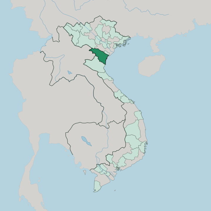


Towns & cities in Tỉnh Thanh Hóa
Pick a town or city — each links to where to stay.
The province splits into coast, mountains and the historic plain between. Sầm Sơn is the obvious beach base, a resort town sixteen kilometres east of the main city where the Mã River empties into the sea. Trekkers go west.
Pù Luông is the draw there, where Thái and Mường households rent out stilt-house rooms above the rice terraces. The city of Thanh Hóa is the transport pivot, on the North-South Railway. Choose the coast for sand, the northwest for trekking, and the quiet limestone country around the Citadel of the Hồ Dynasty when ruins and rice fields are what you want.
About Tỉnh Thanh Hóa
Few Vietnamese provinces carry as much dynastic weight.
What is Tỉnh Thanh Hóa known for?
Thanh Hóa was the seat of the Hồ dynasty, whose stone Citadel of the Hồ Dynasty still stands, and the home ground of Lê Lợi, who launched the Lam Sơn uprising against Ming occupation. Its bronze past runs older still: the Đông Sơn drums that name an entire Bronze Age culture were unearthed on the banks of the Mã River. Beaches draw the crowds too.
Sầm Sơn fills every summer, while trekkers head inland to the terraced valleys of Pù Luông.
Where is Tỉnh Thanh Hóa?
Thanh Hóa anchors the northern end of Vietnam's north-central coast, the point where the Red River lowlands to the north give way to the narrow middle of the country. It reaches wide, from the western hills to the open sea. Ninh Bình and Sơn La border it to the north, Nghệ An lies to the south, and the Gulf of Tonkin fills the entire eastern shore.
Its western wall is different. A mountain frontier of more than 192 kilometres runs against Laos, and those ranges belong to the Annamite Range that divides Vietnam from its neighbours. Hills and mountains cover roughly three-quarters of the province, climbing to average heights of six or seven hundred metres in the west before the land drops toward the sea.
Rivers did the rest of the work. The Mã River gathers nearly every stream in the province, loops out into Laos and back, takes in the Chu, and spreads the wide alluvial plain that ranks as the third-largest river delta in Vietnam. That plain holds most of the towns, the rice and the people.
Near the coast the Mã breaks into broad estuaries around Sầm Sơn and reaches the Gulf of Tonkin along a shoreline of about 102 kilometres. Farther inland the karst hills of Pù Luông Nature Reserve rise in the northwest, wrapped in the largest limestone forest in the north of the country.
What is Tỉnh Thanh Hóa like?
Thanh Hóa thinks of itself as a cradle of kings, and the pride shows. This is the province that gave Vietnam the Hồ and the Later Lê dynasties, and that memory colours its festivals and its temples. Every autumn the Lam Kinh Festival fills the wooded shrine complex in Thọ Xuân, honouring Lê Lợi with palanquin processions, incense and folk dance.
The population is mostly Kinh, the Vietnamese majority, settled across the lowland plain. The hills are another matter. Mường and Thái communities hold the western districts, with smaller numbers of Thổ, Dao and H'Mông, and their stilt houses, weaving and lunar-new-year rituals give the uplands a distinct texture.
Vietnamese is the common language throughout. Food is a point of local pride. Thanh Hóa is known across the country for nem chua, a tart fermented pork roll bound in guava leaves and eaten cold with garlic and chilli.
The deep past sits close to the surface here too. It was on the banks of the Mã River, at Đông Sơn village, that the bronze drums of the Đông Sơn culture first came to light, and the province still treats that Bronze Age name as its own.
What is the history of Tỉnh Thanh Hóa?
Thanh Hóa's recorded past is a story of dynasties born on the Mã River. In 1400 Hồ Quý Ly seized the throne, founded the Hồ dynasty, and moved the capital of Đại Ngu to a great stone fortress here, the Citadel of the Hồ Dynasty that UNESCO later listed as a World Heritage site. The Ming soon overran the country.
Resistance gathered in the hills of Lam Sơn, where Lê Lợi began his uprising in 1418 and, after ten hard years, drove the Ming out and founded the Later Lê dynasty. The province took its modern shape under the Nguyễn reforms of 1831.
What is the climate of Tỉnh Thanh Hóa?
Thanh Hóa runs on a tropical monsoon rhythm, split between a wet half and a dry half. Summers, from May into August, turn hot and sticky, with the thermometer often climbing past thirty degrees and the heaviest rain arriving between July and November. Then the storms come.
Typhoons spinning in off the Gulf of Tonkin can swing hard into the coast in the early autumn, flooding the Mã River plain. Winters are cooler and drier, settling into the middle teens once the northern air pushes down. Spring is the soft season, cool and damp before the heat returns.
How do you get to Tỉnh Thanh Hóa?
Most travellers reach Thanh Hóa overland from Hanoi, about 150 kilometres to the north. The Reunification Railway and National Route 1A both run the length of the province, stopping in the main city on the Mã River, so trains and buses from Hanoi or from Nghệ An to the south are the usual way in. There is a quicker option.
Thọ Xuân Airport, west of the main city, links the province to Ho Chi Minh City and other domestic hubs by air. From the city, roads fan out east to Sầm Sơn and the coast and northwest toward Pù Luông and the Laos border.
Good for
Updated July 2026