Vietnam
An Giang, Vietnam — Towns & Travel Guide


An Giang is the western edge of Vietnam's Mekong Delta, where the Seven Mountains rise from rice plains between the Tiền and Hậu rivers.
About An Giang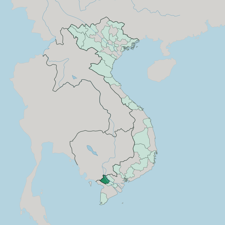


Towns & cities in An Giang
Pick a town or city — each links to where to stay.
Two towns hold nearly all the province's beds. Long Xuyên, the largest city, spreads along the Hậu River and works as a base for the floating market and the Óc Eo plain to its south. Châu Đốc sits upriver near the Cambodian border, at the foot of Sam Mountain and its Bà Chúa Xứ temple, and it is where river boats leave for Phnom Penh.
Choose Châu Đốc for pilgrimage, the Seven Mountains, and the Trà Sư melaleuca forest nearby. Pick Long Xuyên for the delta itself. Homestays sit in the Cham villages across the water.
About An Giang
What is An Giang known for?
An Giang breaks the delta's flatness. Across the western Mekong Delta its plains stay flat, yet the Seven Mountains rise abruptly near the Cambodian border, the only real hills in the region. Châu Đốc draws pilgrims to the Bà Chúa Xứ temple below Sam Mountain, among the busiest shrines in southern Vietnam.
Rice paddies, floating catfish farms, and pungent fish-sauce markets line the Tiền and Hậu rivers. Long Xuyên anchors it all. Kinh, Khmer, Cham, and Hoa families have worked this borderland together for generations.
Where is An Giang?
An Giang lies in the western Mekong Delta, in the southwest of Vietnam, where the great river braids toward the sea. It fills the land between the delta's two main channels. The Tiền River runs along its northeast, the Hậu River, the Bassac, cuts through its heart, and canals thread the flat ground in between.
To the northwest the province meets Cambodia along a border traced for much of its length by the Vĩnh Tế Canal. Đồng Tháp lies to the east and Cần Thơ to the southeast. Most of An Giang is floodplain, barely above the water. Then the ground rises.
In the southwest, around Tri Tôn and Tịnh Biên, the Seven Mountains break from the plain, the only real relief in the whole Mekong Delta. Sam Mountain stands apart near Châu Đốc, close to the Cambodian line. Between the hills and the rivers spread rice fields, orchards, and the flooded Trà Sư melaleuca forest.
South of Long Xuyên, on the Thoại Sơn plain, lie the brick ruins of Óc Eo, an ancient port worn down into the paddies. Long Xuyên sits on the Hậu River; Châu Đốc guards the upstream border. Across An Giang, the water sets the shape of the land.
What is An Giang like?
Few provinces in Vietnam are as mixed as An Giang. Kinh farmers share the delta with Khmer, Cham, and Hoa neighbours. Cham Muslim villages line the Hậu River near Châu Đốc, their stilt houses, silk looms, and small mosques facing the water.
In the Seven Mountains around Tri Tôn, Khmer communities keep Theravada pagodas whose spires rise over the rice, and the Bảy Núi ox races run there each harvest. It is a rare corner of the delta where minarets and pagoda roofs stand within sight of the same fields. Hòa Hảo was born on this soil.
A reformed Buddhist religion founded in the riverside village of Hòa Hảo, it still draws most of its followers from An Giang and the towns along the Hậu River. Pilgrims climb Sam Mountain to the Bà Chúa Xứ temple, whose spring festival is honoured as a national heritage. The kitchens are just as distinct.
Châu Đốc is known across Vietnam for mắm, its pungent fermented fish, while Khmer villages boil dark palm sugar from thốt nốt trees. Out on the water, families raise tra catfish in cages beneath their floating houses. Markets float.
Everything here bends toward the river.
What is the history of An Giang?
An Giang's story starts at Óc Eo. On the Thoại Sơn plain stood a port of the Funan kingdom, trading with Rome, India, and China in the first centuries of the common era. The delta was later frontier land, claimed by Vietnam only in the eighteenth century as settlers pushed south.
Under the Nguyễn emperors labourers dug the Vĩnh Tế Canal along the Cambodian border, and the province of An Giang took its modern shape in 1832. Hòa Hảo Buddhism began here in 1939.
What is the climate of An Giang?
An Giang runs hot all year. Its climate is tropical monsoon, split into two seasons rather than four. The dry months, roughly December to April, leave the Hậu River low and the Seven Mountains hazy.
Then the rains arrive. From around May the southwest monsoon soaks the delta, and by late summer the Mekong swells and spills across the fields in the flood the locals call mùa nước nổi, the season of floating water. Boats replace bicycles on some lanes.
The water sinks again by winter, leaving fresh silt on the rice.
How do you get to An Giang?
An Giang runs without an airport of its own. Most travellers reach it by road from Hồ Chí Minh City, a drive of several hours southwest into the delta, or fly first into Cần Thơ to the southeast and continue overland. The province rewards arrival by water too.
Speedboats run up the Hậu River between Châu Đốc and Phnom Penh, one of the oldest border crossings into Cambodia. From Long Xuyên and Châu Đốc, buses and ferries fan out across the rest of the delta. The delta keeps its river habits.
Good for
Updated July 2026